CHEOPS ATLAS
¦ GLACIATION — UNIVERSUMS HISTORIA — Nov2019 | a![]() production 2020I1 | LastUpdated:
2025-01-13 · Universums Historia ¦ HumanRight — a knowledge domain
production 2020I1 | LastUpdated:
2025-01-13 · Universums Historia ¦ HumanRight — a knowledge domain
innehåll
content denna sida · webbSÖK äMNESORD på denna sida Ctrl+F · sök ämnesord överallt i index SAKREGISTER · förteckning alla webbsidor
all websites
NatCH ¦ CheopsATLAS-Begin ¦ CheopsATLAS-Pyramids ¦ CheopsATLAS-TNED ¦ CheopsAT ¦ Appendix
ADDITION 10Jan2024: Resolution 217 ¦ CALTEP
¦ Course19th
¦ MENU ¦ PetriePlate9issues
RECOMMENDATION: DO NOT USE MICROSOFT AND GOOGLE WEB
READERS HERE — THESE HAVE from 2015+ SMALL TEXT DIMMING FEATURES, DEROGATING —
COPYRIGHT INFRINGEMENT — THE ORIGINAL TEXT.
USE SAFARI OR FIREFOX, OR OTHERS IF POSSIBLE: CLEAR,
SHARP, EXACT. Enjoy,
|
|
Cheops
Atlas Portal THOUSANDS
OF YEARS BACK FROM HERE some established sources claim, in some parts, a
no-easy- explainable
glaciation history — only over the northern Earth part. THAT promotes a
further GeoATLANTIS investigation.
We will try to illuminate those specific glaciation aspects in this CheopsATLAS
appendage. |

— Calling ATLANTIS .. ello ..
ello .. 222 ..
333 .. ¦ ATLANTIS ¦ GTursprunget2019 ¦ AtlantisAPPENDIX ¦
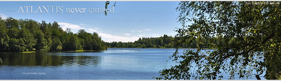
— Roger .. Roger .. Mayday .. Mayday .. A GEOATLANTIS might EXPLAIN some GLACIATION VARIATIONS — GeoATLANTIS NORTHERN HEMISPHERE
GLACIATION VARIATIONS
By natural reasons — the rJCIRCLE complex — the
glaciation aspects mentioned
here have no representation in established quarters: the subject deals with
»unknown territory».
With
an appropriate geophysical land history, a POSSIBLE Geo Atlantis alternative
seems plausible. But our most prominent critical question still is:
— Is
such a geophysical history at all possible? Expert’s Answer not yet found.
This
is: A continuation from Sw.orig.
CR2017 — with some broader examination
of The GeoAtlantis alternative (14Dec2019).
• Background.
• CHEOPS PYRAMID
EXPOSES A CONTRACTED CONSTRUCT: a provable precision building plan:
— From where?
RESULT:
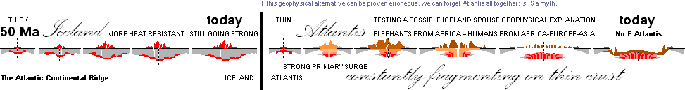
— The urge to find a possible explanation has focused on
a possible geographical early but (until a final collapse some perhaps 50 000 –
15 000 years ago) constantly continental drift fragmenting Atlantic land bridge
between America and Africa-Europe.
In rough figures: Todays distance
between America [Florida] and Africa-Europe shows on a world map roughly 0.12 M
· 50 T6 = 6 thousand
kilometers. That makes a mean yearly average separation of the same 0.12 meters
or 4.72441 inches per each year during the past 50 million years. That is
[well] enough to crack, break and breach a thin fragile land mass —
periodically — having established earlier through a primary volcanic eruption
[periodically renewed through further volcanism] — as Iceland did but surviving
on a more heat tolerant [ceramic] rocky ground: still going strong. The more
southernly parts — ATLANTIS — »did not survive». The
possibility, if geophysically relevant, is the more interesting as the crucial
period involves the first appearing humans on a full developed biological scale
[fully rounded skulls, elastic and resilient Walk: The Woman as we know Her [The
Nature Form no born man can resist]: The Pearl of our Universe].
— Reports claiming enigmatic glaciation events over the
past amount of some thousand years only over the northern hemisphere has
exaggerated the urge of testing, as these reports obviously promote a possible
early Geo Atlantic land region: during a geological period, opening and closing
the North Atlantic Current with following consequences.
— We will study some quotes on these reports in this
presentation — eventually trying to exclude weak associations.
ATLANTIS
CHEOPS — or a Cheops ATLAS seems about to be revealed in its entirety
IF
the following geological parts do have a solid physical ground.
A
continuing with further examination of the GeoAtlantis alternative (14Dec2019)
GEOLOGICAL
GLACIATION VARIATION DATA [GGVD]
SUPPORTS AND FAVORS THE GEO ATLANTIS ALTERNATIVE
GEOLOGICAL GLACIATION DATA PROMOTE AND
SUPPORT THE GEO ATLANTIS ALTERNATIVE [GGVD]
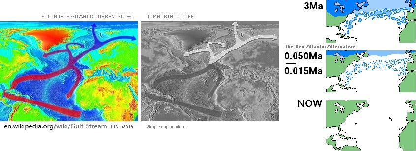
DEEPENED ARGUMENTATION — North Atlantic Current washes away ev. Atlantic
artifacts by time
Established
sources point out that MANY glaciation periods have occurred during the Earth’s
surface geological history.
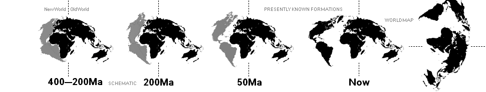
We
only have to focus on the part in concern of the introduction
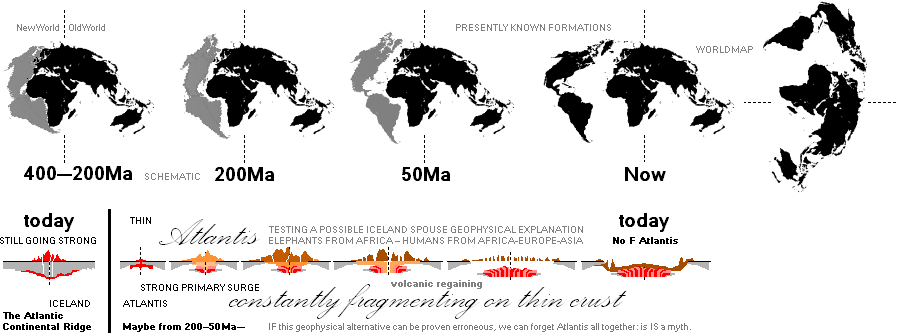
(400–200–50
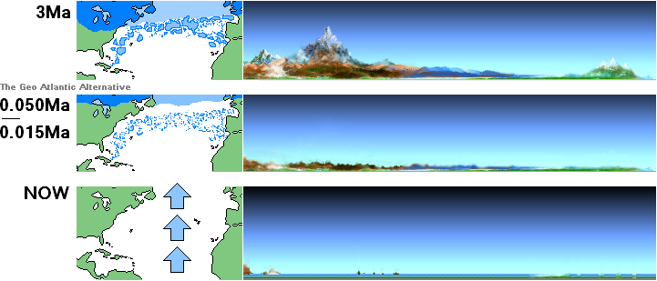
Ma) of the the so called continental drift, schematically illustrated below.
—
Roughly 200 Ma America Africa-Europe begins to separate. That introduces us to
the actual Geo ATLANTIS alternative (Sw. Geo
ATLANTIS alternativet), how it
started in any possible true geological scenario.
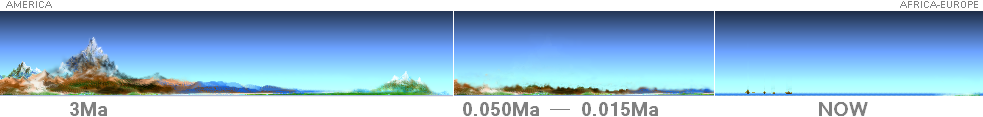
More
closely there is a (known, in parts) 3 Ma reference specifying the beginning of
the latest (great) glaciation period (conv., the Quaternary Glaciation). Its
possible extension can be used here as an illustrating base, as its geology is
claimed to be well documented.
See in explicit the MaMap.
A corresponding
GIF-animated WorldMap evolving sequence
— Ma, abbreviated from Million years
ago
— fairly similar to the below, left
part America-AfricaEurope only — is found @Internet on the website
https://gifer.com/en/7NOj
The illustrated parts summarizes the
introduction to the continuing and testing investigation of the Geo
ATLANTIS alternative: Its eventual connection to our
physical reality. See further quotations in GGVD and IcyNORTH.
IF
THE Geo
ATLANTIS alternative has a
real geophysical foundation
— a
thin volcanic rebuilding-fragmenting America-Africa-Europe continental forcing
barrier form — it ought to expose a significant influence on the streaming of
oceanic water between equator and north pole.
—
What the established sources sensationally say:
No south pole. Only north.
The
affected part is only over the north part.
—
It fits our Geo Alternative as the hand in the glove.
What
has been reported (-Dec2019):
—
Only exclusively (unique, some mysterious and strange, hard to explain
oceanic) glacial variations appear over the north hemisphere — earliest from the beginning of the America-
Africa-Europe continental drift (400-200 Ma). See further quotes in GGVD.
Known
test period from 3Ma
We
have — through already well established sources — one reference at ca 3Ma (Ma,
Million years ago),
Sw.
” Istiden började för omkring tre miljoner år sedan, men glaciärerna har bara
avancerat då och då och de har aldrig nått längre än till tempererade
breddgrader.”, CG1984s28.
Eng.
The ice-age began about three million years ago, but the
glaciers have only advanced now and then and have never reached further than
temperated zones.
Same
type of specification exists on Wikipeida (Quaternary
glaciation, 10Dec2019) dated beginning 2.58 Ma, part of illustration
below.
Ma, Million years ago — Agif
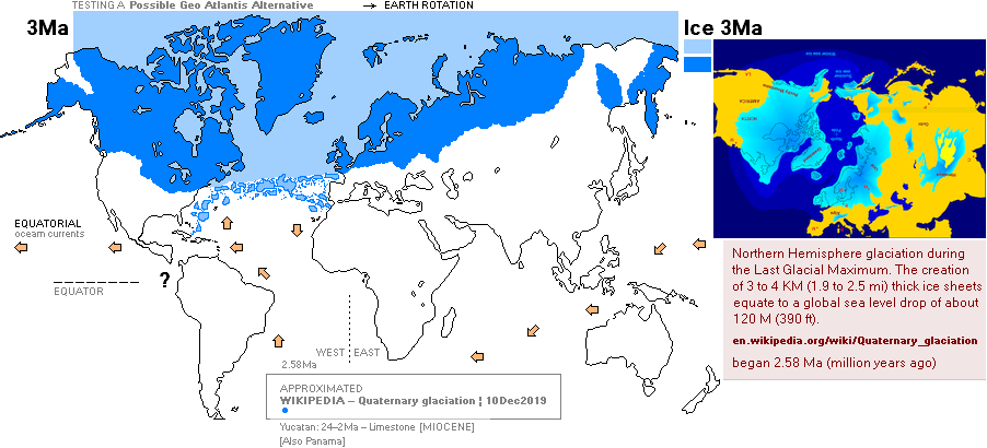
The World Map above illustrates a
corresponding — possible — picture of a Geo Atlantis Alternative. The known
period around 3 Ma is marked with blue for its (Wikipedia, Quaternary
glaciation) ice cover. See further described and illustrated in GGVD with quotes.
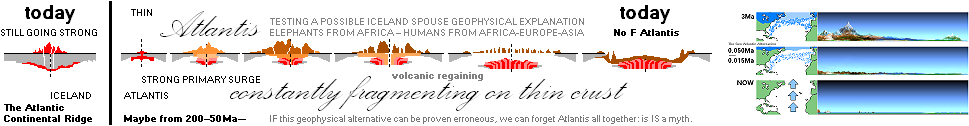
— The testing form suggests a
corresponding geologically — possible — evolving scenario in the land formation
phase history.
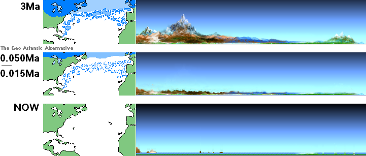
Geo Atlantis Alternative’s suggested
conditions, its formation on a specifically thin Earth crust (200—50Ma) —
contrary to its spouse Iceland who survived the continental drift on a more
heat resisting rocky ground with less dramatic drift — has extraordinary
qualities in explaining the otherwise mysterious fast and vast northern
hemisphere variations in glaciation: early seismic fragmentation on an early
Atlantic fragile land form fed by a powerful continental drift, partly
rebuilding new land through continuing volcanism. Today this volcanic activity has slowed down, now mostly active
at sea bottoms several kilometers deep under the ocean surface.
See citation in GGVD.
When the land formation finally
ceases, and the North Atlantic Current establishes its streaming route, (0,015—0,011 Ma), all previous
fragments and traces of that land at the bottom of the the Atlantic ocean is
rinsed away by the ticking seconds of time. Not a The F Word single trace of
any Atlantis.
— But: is that scenario really geologically
possible? No certain answer to that question is known here.
AtlantisCHEOPS ¦ AgifRef ¦ MaKartan
— The
enigmatic fast changes in glaciation periods only over the northern hemisphere,
nothing over the southern parts.
IcyNORTH
” The
abrupt climate changes that occurred during the last glaciation and
deglaciation
are mind boggling both in terms of rapidity and
magnitude.”, Seager2007a.
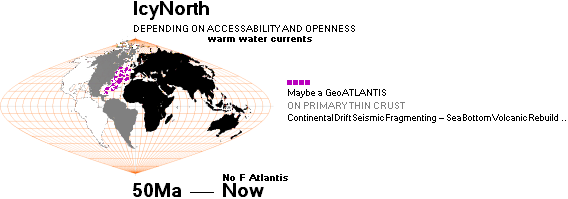
This GeoATLANTIS TEST encourages the
enigmatically stated fast and strong variations inside the latest known
glaciation periods.
Evolving
scene:
Ma, Million years ago
If,
during some geological period, a geological DOOR once existed between America
and Africa-Europe
—
seismically partly fragmenting from continental separation, partly rebuilding
through volcanic activity
— it
could explain the reported strange (enigmatic, mysterious)
glaciation fast and vast changes in the nearest past.
Several
describing articles (@INTERNET) are available explaining how the North Atlantic
Current
(Wikipedia
@INTERNET and others: North Atlantic Current)
is
affecting the north pole’s ice growth or decline. Citations with references
below.
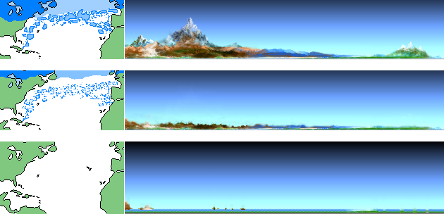
SURFACE AREA CORRECT MAP PROJECTION OF EARTH GLOBE.
Antarctic (South pole) not included. Sequences
schematically only in left map part, its continental drift
America-Africa-Europe earliest 400 Ma, Million years ago.
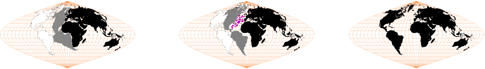
If we hypothetically include a South pole Antarctic land in the
leftmost picture, we have an Earth globe divided approximately in one part 50%
land and one part 50% open and isolated ocean: equatorial oceanic current
streaming is closed, no opening exists. While water conserves/transports the
daily insolation heat better than rock around the World, a possible primary
first glaciation period could have developed over both pole hemispheres with
the early Earth land Passage Closed alternative:
— Mostly 24/7 a closed water basin on the water equatorial side:
Mostly icy on the (northern) land side. But no further information of that
scenario is known here.
— Later, with the Atlantic Continental Drift, the situation
changes — also depending on smaller land bridges (Mexico, Alaska-Siberia) being
opened or closed for water currents.
With
our GeoATLANTIS alternative still under test
(earliest
from America-Africa-Europe continental drift’s beginning [400–200 Ma, Million
years ago])
it
renders easy to see a possible random geological servo process of a
corresponding ice growth or ice decline over the north pole (whole northern
hemisphere).
See
also in FUNCTION.
Depending
on whether the passage America-Africa-Europe is maximized open or closed
—
GeoAtlantis alternative seismic geological fragmenting and volcanic redressing
during some period
— a
momentary growth or decline of ice is seen over the north pole region.
An open passage encourages warm incoming
equatorial ocean water.
A closed passage blocks the warm, and
consequently encourages a colder period.
GeoAtlantis
alternative — if at all geologically possible — gives us (climatologically) an
explaining candidate in a historical window of at least 50 Ma.
—
That is also the most recent period of the whole and complete and full
biological human body physiological development into the form of the human such
as it is known by us today: woman as The example. Can’t beat that. She takes
the breath out of us all: the human form as such. Absolute harmonic beauty on a
full universal cosmic scale.
None
of the sources (@INTERNET) exposing the glaciation enigmatic ”mind boggling”
history contain any mentioning of these here hinted Geo Atlantis aspects, as it
is known here. The general established idea seems to be that the Atlantic
continental drift simply and directly has promoted and shaped a continuous
growing oceanic opening between the two continental plate sites America and
Africa-Europe-Asia — and no mentioning of even a possibility of a connecting
geology. Not even a hint.
In summation: The partly interesting
spot in the available descriptions of the glaciation periods
(the foremost known by the ice core
samples) is the enigmatic part of the
mentioning:
— Apparently completely mysterious
onsets show: (improbable) fast changes occur in ice growth (and decline). That
is a sweet and real opportunity for a Geo Atlantic fragmenting volcanic
refreshing geology servo motor, capable of giving a (fast) opening and a (fast)
shutdown — as a door between warm and cold.
— And so, apparently as it is claimed,
only over the northern part of our globe.
NorthAtlanticGlaciationQuotes: IcyNORTH
CHALLENGES
TO OUR UNDERSTANDING OF THE GENERAL CIRCULATION: ABRUPT
CLIMATE CHANGE
Richard
Seager and David S. Battisti, Chapter 12 — April 5, 2007
http://ocp.ldeo.columbia.edu/res/div/ocp/pub/seager/Seager_Battisti_2007.pdf
:
”
12.10. Conclusions
The
abrupt climate changes that occurred during the last glaciation and
deglaciation
are mind boggling both in terms of rapidity and
magnitude.”,
:
”
That winters in the British Isles could switch between mild, wet ones very
similar to today and ones in which winter temperatures dropped to as much as
20◦ C below freezing, and do so in years
to decades, is simply astounding.”,
:
-------------------------
”
12.1. Introduction
About 14,700 years ago
(14.7 kyr BP), towards the end of the last ice age, the climate
warmed dramatically and abruptly around the North Atlantic—by as much as the
difference
between full glacial and interglacial conditions—in
no more than a decade
or two.”,
-------------------------
:
”
This is all the more remarkable because
it occurred in the presence of massive
ice sheets and continuation of the albedo forcing that presumably had been helping
maintain glacial
conditions up to that point.”,
:
”
Broecker et al. (1985) were perhaps the first to suggest that rapid warmings and coolings of climate around the
North Atlantic were caused by rapid
switchings on and off of North Atlantic Deep Water formation with “on”
states being associated with transport of warm waters into the subpolar North
Atlantic.”,
”
Despite difficulties explaining the paleoclimate record of abrupt changes with
the THC theory, no competing idea has yet been
offered.”, Seager2007a.
These
statements WOULD associate nearest to an AMAZING (possible GeoAtlantis) COINCIDENCE. The continued flow of water during (the
nearest 10 000) years (with oceanic sea floor geological sedimentation and
continued continental drift with its ocean floor volcanic activity) has
effectively wiped out and away any possible traces: No F Atlantis.
”
More recently, the greening of the Sahara
in the mid-Holocene,
when
the worlds most impressive desert essentially became a moist savanna, remains a
fascinating unexplained phenomenon. Certainly it was triggered by orbital changes that
increase
summer insolation over the northern hemisphere, but
the apparently abrupt
onset and demise of the
African Humid Period (deMenocal et al. 2000), and the
fact that
other Northern Hemisphere monsoon regions show less
impressive changes, suggest a
nonlocal coupling between deserts and monsoons on
paleoclimate time scales that is
waiting to be elucidated.”,
:
” In
summary, abrupt climate changes,
consisting of coolings followed by rapid
coolings and then abrupt warmings, punctuated the entire glacial period at Greenland,
but no such thing happened in Antarctica. At Greenland, there is enticing evidence of
nonlinearity
of the climate system with thresholds and
switches.”, Seager2007a.
Wikipedia
(14Dec2019) has the same type of North Atlantic Current consensus — with an
underlined common idea of an unbroken Atlantic passage:
WIKIPEDIA,
QUATERNARY GLACIATION
https://en.wikipedia.org/wiki/Quaternary_glaciation
:
” An
important component in the development
of long-term ice ages is the positions of the
continents.[16] These can control the circulation of the oceans and the
atmosphere, affecting how ocean currents carry
heat to high latitudes. Throughout most of geologic time, the North Pole appears to have been in a
broad, open ocean that allowed major ocean currents to move unabated. Equatorial waters flowed into the polar regions,
warming them. This produced mild, uniform climates that persisted
throughout most of geologic time.”,
:
”
But during the Cenozoic Era, the large
North American and South American continental plates drifted westward from the
Eurasian plate. This interlocked with the development of the Atlantic Ocean,
running north-south, with the North Pole in the small, nearly landlocked basin
of the Arctic Ocean.”,
:
”
The Drake passage opened 33.9 million years
ago (the Eocene-Oligocene transition), severing Antarctica from South
America. The Antarctic Circumpolar Current could then flow through it, isolating Antarctica from warm waters and triggering
the formation of its huge ice sheets.”,
:
”
The Isthmus of Panama developed at a
convergent plate margin about 2.6 million
years ago, and further separated oceanic circulation, closing the last strait, outside the polar
regions, that had connected the Pacific and Atlantic Oceans.[17]”,
:
” This increased poleward salt and heat transport,
strengthening the North Atlantic thermohaline circulation, which enough supplied moisture to arctic latitudes to create the northern glaciation.[18]”,
:
” Thick glaciers were heavy enough to reach the sea
bottom in several important areas, thus blocking the passage of ocean water
and thereby affecting ocean currents.
In addition to direct effects, this caused feedback effects as ocean currents
contribute to global heat transfer.”,
:
” Glaciation has been a rare event in Earth's history,[28]
but there is evidence of widespread glaciation during the late Paleozoic Era
(300 to 200 Ma) and the late Precambrian (i.e. the Neoproterozoic Era, 800 to
600 Ma).[29] Before the current ice age, which began 2 to 3 Ma, Earth's climate
was typically mild and uniform for long periods of time.”,
:
” The warming trend following the Last Glacial
Maximum, since about 20,000 years ago, has resulted in a sea level rise by about 130 metres. This warming trend has subsided about 6,000 years
ago, and sea level has been comparatively stable since the Neolithic.”,
:
” The present interglacial period (the Holocene) has been
fairly stable and warm, but the previous one
was interrupted by numerous cold spells lasting hundreds of years.”, WikiQuater.
WIKIPEDIA,
QUATERNARY GLACIATION
https://en.wikipedia.org/wiki/Quaternary_glaciation
:
”
Currently, Earth is in an interglacial period, which marked the beginning of the Holocene epoch. The current interglacial began between 15,000 and 10,000 years ago;
this caused the ice sheets from the last glacial period to begin to disappear.
Remnants of these last glaciers, now
occupying about 10% of the world’s land surface, still exist in Greenland,
Antarctica and some mountanious regions.”
WIKIPEDIA,
AFRICAN HUMID PERIOD
https://en.wikipedia.org/wiki/African_humid_period
:
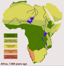
Africa — SAHARA — geologically
mapped ca 7 000 ya
”
The African humid period (AHP) is a climate period in Africa during the
Holocene during which northern Africa was wetter than today. It .. involved
changes in vegetation and dust in the Sahara that altered the African monsoon,
the disappearance of much of the Sahara desert which was replaced by grassy
vegetation, trees and lakes and the settlement of the former desert by various
animals and humans, who lived as hunter-gatherers. It has had profound effects
on present-day Africa such as the birth of the
Pharaonic civilization and the pyramids and potentially also the
development of widespread Golden Age myths.”,
CONCLUSIVE
ASSOCIATION WITHOUT FURTHER PROOF:
—
»The Pyramids Came About when Sahara was Green».
(Wikipedia
increases the odds).
See
also NatCH.
NOTE24Feb2024: UPDATED
ORIGINAL — 2017+
Additional note 245Feb2024 — the Conclusive above:
With the updated (RadioCarbonDating on the Cheops Pyramid mortar) information in CALTEP, the enigmatic and troublesome ”The Cheops Pyramid before 3000 BC” argument is not valid anymore.
(And neither is »the enigmatic emigration» of the hypothetic Atlantis population).
A sudden (everything explained) breakthrough has been exposed:
— »a seemingly full and complete consequential mathematical explanation» .
BASIC ARGUMENT as exposed from Appendix in this presentation:
— No way the level of physics and mathematics explaining (TNED) the Cheops Pyramid building and its interior was present in the early primitive human civilizations, the way these are known and interpreted in present history books.
Full explanation in Resolution
217
ALL THE PREVIOUS PRESENTATIONS IN this CHEOPS ATLAS document series complex (2017+) suffer the same consequential mathematics forced resolution:
On a necessary Earth ground Bound Hi Tech Atlantis culture — which fragmented .. leaving us in utter ignorance on explaining the history behind ..
— »the Pyramids, Cheops Pyramid and others, already
stood there at the present established literary typically testified (CameronREF)
sudden birth of the Egyptian civilization, around some 3000 BC».
— THAT was (what made the lock in) the enigmatic Quest which cannot be explained in detail:
— How, where.
— It had to be implied: unanswered.
Now (Feb2024) we are facing a new situation (the Radiocarbon dated Cheops Pyramid masonry mortar: it contains organic rests, dated farthest 2 900 BC).
— Our basic (fatal) idea that a (necessary, but never proven as such) High Tech Atlantis civilization was, had to be with no argumentation at all, Earth ground bound and based (consequential mathematics), was — until now — a fatal idea hiding the true consequential mathematical answer (now clarified from the Wikipedia article detail Radiocarbon dating on the Cheops Pyramid mortar content — not earlier noted in this production).
Namely:
— The possibility — hi tech
principally free energy — to be independent of Earth geological changes:
building airborne (huge) platforms from where a more elegant and stable
organization — during longer periods — could be managed.
Bonus: all history explained. Every atom of it. TEST IT — down to the last atom.
— Why didn’t we think of that simple and most
elegant consequential mathematics solution and explanation from the start?
— »The authors don’t like heights very much». There is always a trivial reason.
— Because there was no known argument stopping us from building on the idea of a permanent Earth ground culture — with all its enigmatic unanswered questions.
— What broke the ice?
— The Wikipedia passage (not
earlier observed) of the radiocarbon dating: the mortar used in the stone
masonry of the Cheops Pyramid. It contains rests from organic (ashes) material
— dated at most latest 2 900 BC. That kills every available suggested idea that
»the Pyramids already stood there, a long, long time ago». Then the whole
history becomes consequentially explained. All the way, all details of
the puzzle: TRY TO BREAK IT DOWN.
— The technological knowledge is the old aspect. Not the Pyramid as such.
To be corrected if faulty.
See full scenery explanation from RADIOCARBON DATING.
— No way the level of physics and mathematics
explaining the Cheops Pyramid building and its interior, as it is (2017+)
presented in this CheopsATLAS series documents, was present in the early
primitive human civilizations. The way these are known and interpreted in
present history books have absolutely no connection. No way. So,
to conclude on consequential mathematics, what we know:
Reminding the necessary technological level (TNED familiarity: EARTHrJCIRCLE mathematics and physics):
—————————————————————————————————
ASSUMING AND TAKING FOR GRANTED that the Atlantic original region DID fragment as is suggested in these Glaciation view arguing statements, the Atlan population soon realized this (on an already established confirmed TNED deduced hi tech free mc² energy ATA/CAT foundation THE GAMMA PROJECT [still Mar2024: no direct electronic-instrumental gamma proof on the table, yet. But it is only a matter of time until it comes. And when it does, the world will most certainly change, fast ..] — deduced nuclear physics, proving and explaining present academia as a Primitive — because it invented on consensus instead of deducing on knowledge: consensus is not a scientific subject, but knowledge is):
— If we are not to get shredded ourselves in time by millennia intervals by this fragile local Earth geological structure, and our technological culture as well, we have to build (huge) airborne plant platforms, having these as stationary offices high above Earth ground, and thereby independent of Earth ground geology changes over millennia.
— From there, we can organize — better — our future civilization, taking advantage of the most favorable sites at Earth ground, with stations for food and material supplements, and some stationary settlements, for those of us who so wish.
Such a perspective is readily
out of question in the present Earth world academic primitive idea of the
atomic and nuclear physics: no way. Not even close.
A NEW SCENE — the number of humans on Earth say some 10 000 BC was what we know small
———————————————————————————————————————
The Atlans BUILT and emigrated — to (HUGE) Airborne Tech (with many smaller migration ships, frequently visiting Earth ground stations: food, material and general maintenance). So: Their civilization was never (ultimately) destroyed by any at all a geological catastrophe — although the original land sites would have to meet such a fate. The Atlans gradually »vaporized» — and became smoothly and perfectly undetected integrated in time with the rest of the human very much less intellectually developed civilization sites — however on the condition of their level: no force, no violence (non Atlantic populations: comparatively slow mental evolution/awakening, and so during [many] millennia — that seems to be a necessary puzzle: fairly comparable to the present academia and its idea of such a level of knowledge: retarded, low educated: not possible at all, no way, not even close)
— The most interesting: FIND an argument to disclaim all this found and revealed.
None yet found. Still searching.
Provided the Atlans themselves did not start civil wars and hopeless disputes, such a hi tech culture would in principle last forever (until the Sun dies).
— It would need a one human family consciousness in full awareness of the situation.
And that is the problem of our time: state administrative human right recognition:
Not one word. Not a spell. Not a sound. No daily talk: Nobody talks it.
” They are endowed with reason and conscience ..”, A1 UDHR10Dec1948.
— Oh yeah .. Exemplified where? UN: Just give us one example.
Cannot handle civilization. Cannot handle life. Cannot handle communication.
Human right recognition: suspended. A prison for humanity.
World wide state persecution of violence refusers. Very high tech. MustBuyBook.
Very educated, high level IQ.
If any of these aces enter a store, the merchandise shows tendency of going out.
Retarded, is an upgrade. Disclaim.
— What happened to their hi tech energy science, and its shipments, what became of these, and (above all), why the reason to build Pyramids (around 3 000 BC) and how would all of it be rationally and logically explained in a left Explaining Script?
— See the suggested Consequential Mathematics Scenery explanation in the following appendix from RADIOCARBON DATING.
And so it is — now, finally — possible to explain the (entire ancient) history on that premise. See further in the following appendix from RADIOCARBON DATING.
Editor2024II29
IcyNORTH ¦ NorthAtlanticGlaciationQuotes ¦ Seager2007a
¦ WikiQuater
¦ InterGlac100
¦ WikiHolo
¦ WikiSahara
¦ NOTE24Feb2024
FAN: ¦ sw. fördjupad argumentering ¦ Function
NORTHERN
HEMISPHERE GLACIATION VARIATIONS
INTENSIFIED EXPLANATION
SHORT ENGLISH:
— IF the GeoAtlantis Bridge alternately on
its (here for further test) presumed
primary thin Earth crust is (seismically due
to The Continental Drift, TCD) fragmenting and partly (for some time) recovering from the ocean
bottom volcanism, then also a ”door” sometimes is open and sometimes is closed
to the North Pole — regulating the flow of warm equatorial ocean water:
RANDOM (short time) glaciation regulation
occurs, together with a ”wash-out” of previous remnants and sediments on the
actual GeoAtlantis (former) land base. [But
this scenario must be confirmed by geological experts, if valid].
With this possible scenario, the late
findings 0.011Ma (CG1984) of elephant teeth on North America’s east
coast need NOT to be the (here) earlier stated absolute MARKER of ”a latest
possible GeoAtlantis” existence (as [such]
Atlantis artifacts have not been found [at all] on the Atlantic ocean floor).
This (enhanced) alternative gives us a
better (more profitable) margin to test and relate a possibly Late GeoAtlantis
populated crew MUCH CLOSER to our own time than ”no nearer than 0.050Ma to give
»margins»”.
If this holds, we are better equipped to
relate the historical gaps between the different possible stages.
All here collected quotations from
Wikipedia on Glaciation mentions, and underlines, the (vital) role of the North
Atlantic Current (NAC) — left upper dark blue extending from the Gulf Stream.
NAC is the main Transit Route of warmer equatorial sun heated water upwards
towards the North Pole. As far as the Atlantic passage is OPEN, this North Pole
warm incoming water guarantees that any existing ice reduces to a minimum.
— However in these browsed articles,
it is not even hinted at, nor mentioned as a possibility, that a possible land-bridge
(The GeoAtlantis
Alternative) — if at all present — SHOULD function as a North Pole
GLACIATION Regulator — to and fro, depending on extension.
— The GeoAtlantis Alternative poses
such an alternative, however as yet not verified as a real geological
possibility other than exposed in this presentation: primarily created 200-50
Ma (Ma, Million years from now) on thin crust by volcanic activity — a fragile
spouse to the more solid ICELAND alternative — from the
beginning of The Continental Drift (TCD). TCD guarantees that any
America-AfricaEurope build up on a thin crust will be seismically shredded by
time, and in different (random) outbursts, with a possible ongoing recovery
from new volcanic out-fills, see right part of the illustration above.
We would very much like to know if there are any kind or sort of
strictly geological arguments to refute such a possibility — because IF the
possibility is geologically valid (traces washed away), it also COULD be a
perfect explanation to what today is perfectly shredded and lost a long time
ago: Atlantis.
WIKIPEDIA,
Gulf stream
https://en.wikipedia.org/wiki/Gulf_Stream
” The
Gulf Stream influences the climate of the east coast of North America from
Florida to Newfoundland, and the west coast of Europe.”,
” Although there has been recent debate, there
is consensus that the climate of Western
Europe and Northern Europe is warmer than it would otherwise be due to
the North Atlantic drift which is the northeastern section of the Gulf Stream.
It is part of the North Atlantic Gyre.”.
DeTiLi: FAN
DEVELOPING TIME LINE
— All
traces gone from nearest 15 000 years back.
ASSUMING
The Geo Atlantic Door South-North finally became fully opened
— no
more volcanic rebuilding of obstructing land between the continent sites
America and Africa-Europe
— it
will be easy for us to see a most flashing prominent geological effect:
Every
piece of information from a previous land
—
which occasionally sunk to the ocean bottom from tearing seismic continental
drift mechanics
—
will be rinsed and cleaned away northerly by the continuous water current.
With
— nearest — a period of 10 000 to 15 000 years of such open North Atlantic
oceanic current flow, we would expect that nothing, not a smallest trace, will
be found on the Atlantic ocean bottom from a possible early real existing
geological land form. It is all gone, washed away and fragmented and sea
eroded. If remnants still exist, we would look for them at the continental
edges: the only geological and geophysical places excluded from the south-north
pushing and rinsing water currents.
This
Finally Atlantic Opened Door possibility — provided the Geo Atlantis
alternative holds geophysically — gives us a most close possible time line to
set out for the absolute — to our own time closest — remnants of an original
Atlantic culture: no closer than say 15 000 years back.
The findings of elephant teeth [CGsource]
at the northern coast of North America dated farthest 15 000 years back
—
with our first simple critical argument: if these were Atlantic, elephant teeth
would be found all over the Atlantic ocean floor
—
will lose all argue-mental power in aiming at ”why then are there no elephant
teeth all over the Atlantic floor”:
—
Because of the simple fact that these have had just about 15 000 years to be
washed away from the site, due to the North Atlantic Washing Away Every
Possible Trace Current.
So:
— Our
search for a NEAREST ORIGIN (of whatever more profound) will and can, have the
time line as a first set out: No more close to our own time than roughly 15 000
years back.
GEOLOGICAL
GLACIATION VARIATION DATA [GGVD]:
IcyNORTH ¦ NortOnly ¦ Function ¦ FAN
THE
REMARKABLE HERE IS THAT the nearest to our time CHANGE SHOULD HAVE
OCCURRED RATHER SUDDENLY about 14 000
years ago: the glaciation on the northern hemisphere decreases and is reduced
drastically over a shorter time.
— See
also with quoting references in Seager2007a.
Warmer
water from Equator reduces a colder North — no actual news
WIKIPEDIA,
Gulf stream
https://en.wikipedia.org/wiki/Gulf_Stream
” The
Gulf Stream influences the climate of the east coast of North America from
Florida to Newfoundland, and the west coast of Europe.”,
” Although there has been recent debate, there
is consensus that the climate of Western
Europe and Northern Europe is warmer than it would otherwise be due to
the North Atlantic drift which is the northeastern section of the Gulf Stream.
It is part of the North Atlantic Gyre.”.
Our Quest:
— If
— over thousands of years in the
earlier younger Earth geological history
— there is a
holding-stopping-locking-let-go geologically dynamic barrier belt across the
America-Africa-Europe Atlantic ocean
— ongoing geological fragmentation
with volcanic recreation
—
the continental drift works as a tension dragging machine tearing any
eventually earlier formed volcanic land seismically apart
— partly reforming from new volcanic
activity (compare the new island
Surtsey outside Iceland in 1963), during some geological
period,
— there is also, or should also be
provisional conditions for a Northern Atlantic Current to CHANGE
— fluctuate
— over same time periods:
— Warmer equatorial water sometimes
penetrates and sometimes not the northern polar regions.
THEN:
— The reported mysteriously fast and
vast changes over shorter periods receives an explanation.
” The
abrupt climate changes that occurred during the last glaciation and
deglaciation
are mind boggling both in terms of rapidity and magnitude.",
Seager2007.
GEOLOGICAL GLACIATION VARIATION DATA
WIKIPEDIA,
TIMELINE OF GLACIATION (14Dec2019)
https://en.wikipedia.org/wiki/Timeline_of_glaciation
:
”
There have been five or six major ice ages in the history of Earth over the
past 3 billion years. The Late Cenozoic Ice Age began 34 million years ago, its
latest phase being the Quaternary glaciation,
in progress since 2.58 million years ago.”,
:
”
Within ice ages, there exist periods of more severe glacial conditions and more
temperate referred to as glacial periods and interglacial periods,
respectively. The Earth is currently in such
an interglacial period of the Quaternary glaciation, with the last glacial
period of the Quaternary having ended approximately 11,700 years ago,
the current interglacial being known as the Holocene epoch.[1] Based on climate
proxies, paleoclimatologists study the different climate states originating
from glaciation.”, WikiTimeGlac.
Geological proofs of rapid and large
changes in glaciation (icing) 0.0147 Ma ”is simply astounding”:
ABRUPT
CLIMATE CHANGE
CHALLENGES
TO OUR UNDERSTANDING OF THE GENERAL CIRCULATION,
Richard
Seager and David S. Battisti, April 5, 2007
http://ocp.ldeo.columbia.edu/res/div/ocp/pub/seager/Seager_Battisti_2007.pdf
:
"12.10.
Conclusions
The
abrupt climate changes that occurred during the last glaciation and
deglaciation
are mind boggling both in terms of rapidity and
magnitude.",
:
"
That winters in the British Isles could switch between mild, wet ones very similar
to today and ones in which winter temperatures dropped to as much as 20◦
C below freezing, and do so in years to
decades, is simply astounding.",
:
"
No state-of-the-art climate model, of the kind
used to project future climate change within the Intergovernmental Panel on
Climate Change process, has ever produced a climate change like this.",
:
"
12.1. Introduction
About
14,700 years ago (14.7 kyr BP), towards the end of the last ice age, the
climate
warmed
dramatically and abruptly around the North Atlantic—by as much as the
difference
between full glacial and interglacial conditions—in no more than a decade
or
two.",
:
"
This is all the more remarkable because it occurred in the presence of massive
ice sheets and continuation of the albedo forcing that
presumably had been helping
maintain glacial conditions up to that point. But it was not to last.",
:
"
Sometime just after 13 kyr BP this Bølling-Allerød warm period ended as climate
first cooled, and then abruptly cooled, into the so-called Younger Dryas. As
near-glacial conditions returned, glaciers advanced in Europe, and the forests
that had established themselves in the preceding warm epoch died. The Younger
Dryas ended with a second abrupt warming that occurred
over only a decade or so and that shifted temperatures back to those of
the Holocene and of today.",
:
"
The idea that the climate system goes through such abrupt shifts did not take
the
climate
research community by storm but dribbled into acceptance in the 1980s and
the
early 1990s. Only when duplicate ice cores
said the same thing and the evidence was
found in multiple indicators within the ice—oxygen isotopes, dust concentrations, snow
accumulation,
and so on—and could be correlated with terrestrial and marine records
did acceptance that abrupt climate change was a reality
sink in.",
:
"
This gradual acceptance is telling. When Hays et al. (1976) showed just how
well
climate
records from deep-sea cores could be matched to orbital cycles, it was deeply
satisfying:
..",
:
"
Three decades later we are still far from
understanding how orbital changes are
converted into ice-sheet growth and decay. While this is testimony enough to our limited
understanding
of the climate system and general circulation, abrupt
climate change is
now the star witness. In
this case, the climate changes occurred not only abruptly but,
apparently,
in the absence of any external forcing.
The lack of any theory for how such
changes could occur
helps explain the slow acceptance of what the data were saying.",
Established theory seems to have no —
not even a hint mentioned — theory comparable in caliber of The
GeoAtlantis Alternative:
— A geological fragile
America-Africa-Europe formation, partly fragmenting from The Continental Drift
(TCD), and partly (less) recovering from underneath by Atlantic volcanic
activity:
— Disappearing totally in the length
of time.
IT does have a principle — principal, main — physical geological
potential of partly blocking and partly allowing a The North Atlantic Current
to pass
— or be blocked further north.
If so:
— The reported (mysterious, enigmatic)
fast glaciation changes explained.
When The Passage finally ends (DEVELOPING TIME LINE)
— its partly volcanic recovering land
form geological time period ceases
— its remnants (The Continental Drift
seismically shredded [mud, sediments])
on the Atlantic oceanic bottom
effectively is transported away northerly by the current streaming.
— Traces are wept out. The northern
water current effectively hides away any trace of any possible former land
shape or its eventual artifacts: no F Atlantis.
Only
the northern hemisphere:
"
In the two decades since the discovery of abrupt
change, two advances have been
made.",
SEAGER2007;
:
"
First, the spatial pattern of abrupt climate change has been better delimited,
and
it is
now known that these events occurred essentially
synchronously across much of
the Northern Hemisphere
(including the northern Tropics) within the atmosphere, the
surface
ocean, and the deep ocean.",
:
"
Abrupt changes are not
found in the ice records from Antarctica,
and the Southern Hemisphere remains a question because of limited data. These
spatial patterns place some severe constraints on proposed mechanisms of abrupt
climate change.",
:
"
Second, mechanisms have been advanced that revolve around the thermohaline
circulation (THC). Broecker et al. (1985) were
perhaps the first to suggest that rapid warmings and coolings of climate
around the North Atlantic were caused by rapid switchings on and off of
North Atlantic Deep Water formation with “on” states being associated with transport
of warm waters into the subpolar North Atlantic.",
:
"
Despite difficulties explaining the paleoclimate record of abrupt changes with
the THC theory, no competing idea has yet been
offered.",
GGVD ¦ WikiTimeGlac
¦ Seager2007
¦ Function
¦ NorthOnly
Ma, Million
years ago ¦ GEOLOGICAL SCENERY
AppendixResolution217: Mathematical
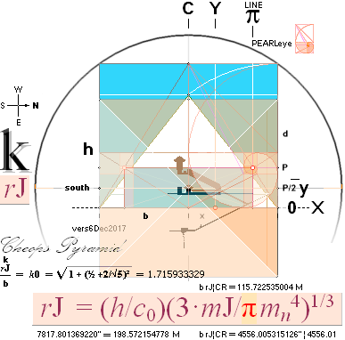
— as the 1883 Flinders Petrie Cheops Pyramid Cheops Rectangle Golden Section
Matrix System provable Solution; Forensic — on the origin of human
history civilization: UDHR10Dec1948;
CAN CONSEQUENTIAL MATHEMATICS [COMA] EXPLAIN OUR
ENTIRE HUMAN HISTORY ON PLANET EARTH? The
will of the people .. Additional NOTE24Feb2024
Resolution
217 — GS Golden Section Matrix Systems
Solutions — with Earth
radius CIRCLE on neutron Dmax density and present mass
— defines the [1881] Petrie measured
Cheops Pyramid half base 4534.40’’ with a 99.9999832% precision: »Resolution
217». The Mi-UNIT ¦ CalculatingThePetrieMeasures ¦ GoldenSectionMatrixSYSTEM
Appendix ADDITION 10Jan2024: ReadITandWEEP: Explained
in Resolution
217 — 4¦9JAN2024 — CheopsAtlasTNED additions
Universe History Content — in a
short summation (4Mar2024)
--------------------------------------------------------------------------
NEUTRON
SQUARE — Planck constant calculating atomic masses
outclasses modern academic atomic and nuclear theory
ALL KEPLER MATH —
proving, comparing and certifying that relativity theory blocks the
understanding of physics
CWON from CAP — Earth
crust isotopic composition with Atmos Bios Litos: the 10 biological equivalents
PO4 — world
laboratory institutions: perform a mass spectroscopic inspection in clarifying
biological O18 over natural O16: deforestation's general biological life power
reduction issue: a growing (respiratory) world pandemic threat situation
RESOLUTION 217 — Proving
the Flinders Petrie 1883 Cheops Pyramid measures to mirror a GS Golden Section Matrix System
solution:
— knowledge of Planck constant
(h=mcr: neutron mass, light propagation in vacuum, neutron gravity spin
radius), Earth mass and average Neutron mass density (Earth mass radius on
that), encircling the geometry explained in Golden Section Matrix System
Solutions, no primitive Egypt culture organization (all human civilization
history explained);
— It occupied the author so
intensely — the illustrated mathematical proof —
that it was completely forgotten, for a short while, until checked, that
RESOLUTION 217 (A) is also the declaration of universal human rights
UDHR10Dec1948 — on the same connection: “..
and all of you are children of the most High”, Ps.82:6; no geographic
Israel. ISRAEL cannot be inherited, does not connect to a physical body. No
mother god loving way. It must be earned (realization through knowledge only).
Cheops Pyramid Resolution 217 testifies a provable connective
Origin of The Script (with a clear bottom line message, especially to UN): no
geographical Israel. Proof of the Origin of Human Civilization: Resolution 217
(the clean 217 resolution as the pure
mathematical Flinders Petrie Cheops Pyramid Cheops Rectangle Golden Section
Matrix Systems Solution; 217 A as our respected UDHR10Dec1948).
Disclaim. Claim whatever you want.
THE CLAIM —
testifying and vindicating the origin of The Script: the urge of UN to clean up
the mess itself has sanctioned: ISRAEL: suicide on humanity. Wake up world:
— Recognition. Not decision.
Decision outside human right recognition has only power to destroy. Present day Earth situation
illustrated.
None
of these features AS SUCH NAMED occupy the content of and in modern academia
(4Mar2024). Never mentioned. No teaching. No education.
THE LEVEL OF PHYSICS AND
MATHEMATICS IN THE CONSTRUCTION AND ITS DETAILED
ACCOUNTABLE PLANNING, PERFECTLY EXCLUDES ANY PRIMITIVE
CULTURAL ORIGIN.
See further short
SCENE in Radiocarbon Dating.
MATH —
Resolution 217 — fully explaining the origin of Human History Civilizations
(disclaim):
INTEGER 217 connects
and defines the Planck
constant neutron Earth mass density Earth rJCIRCLE
Cheops Pyramid Cheops Rectangle GS
Golden Section Matrix System Solution Geometric Corner enveloping sphere, with
a 99.9999832%
confident definition of the 1881-1883 Flinders Petrie
measured half Cheops Pyramid base 4534.40'' = bPETRIE = [h–r/217]rJ √R.
The definition consolidates and certifies a direct and detailed proving
connection between Petrie's quantitative measures and the corresponding calculated
Golden Section Matrix System solution values, as presented. In explicit it
shows on the equative solution to Petrie's
observed and noted (general pyramid constructive) 19th course masonry thickness
— its principal constructive connection to the inner descending corridor and
its angular connection to the Pyramid's outer casing (Second Iterative
Equation) — and their further appearing recursive
constants on the other inner details.
Taken along with The CLAIM — an explicit forensic testimony
evidence, unless disclaimed, concluding a separate, quite different origin of
The Script, the Old Testament, than the one present in established academia —
the summing conclusion strongly points out a complete (deeply academia
rebellious) explanation to our human, generally dim and embarrassingly
difficult to encircle, historical origin on the level of civilization — and
insight into advanced natural science;
WORD —
Resolution 217 (A) — a universally formulated origin on the basis of a concept
— dignity — in concern of caring for a Human Civilized History (disclaim):
— UDHR10Dec1948. 8
introducing Paragraphs, with a following 30 Articles, stressing A Universal
Human Rights Declaration.
— No difference in right and
dignity between born humans: no geographic Israel. No Trafficking.
Concurring in full with the math and (archaeological) forensic GS Golden Section Matrix Systems Cheops
Rectangle Cheops Pyramid 1883 Flinders Petrie measured Resolution 217 part: the
origin.
--------------------
— Children — and even animals —
apprehend that type of simple and easy to understand basics with excellent
perfection.
— So, 2024 world wide business
enterprise United Nation Tourist Cookie Ace, not one word human right
mentioning recognition: where do you come from? Explain.
— Back off.
— »Get the fuck out of my beach».
Stop killing humanity.
Disclaim — Faulty statements are
not allowed here:
—————————————————————————
MODERN ACADEMY TheLIST
AND ITS STATE ADMINISTRATIONS MicrosoftLIST ARE HOLDING HUMANITY
IMPRISONED IN DEEP IGNORANCE
— by drift. Not plan. Provably Low educated,
Retarded, Intellectually
Disabled administrative managements: Cannot
handle civilization. Not even close. Not one word human right recognition. Not
a sound. Not a spell. Not a hint. Again: low educated, retarded. Does not
understand The Concept: dignity — 100% state administrative oblivion Not even a hint. Total Silence. Again:
— Children — and even animals —
apprehend that type of simple and easy to understand basics with excellent
perfection.
— So, again, 2024 world wide
business enterprise United Nation Tourist Cookie Aces,
not
one word human right mentioning recognition:
— Where do you come from, and
when did that happen? Explain.
Connecting Damn
you Microsoft ..
—————————————————————————————————————
WORLD
STATE ADMINISTRATION JURISDICTION
Refuses human computer rights
Disclaim (Mar2024):
—————————————————————————————————————
Uses humanity's collected capacity for developing Computers. World
Trade. Market. All of it.
Then buying up Computer Usage Rights — with state administrative
jurisdictional help —
in order to force — coercive treatment — the workers to also pay —
provide economic support — for what they did create.
———————————————————————————————————
Exceptionally Very high developed
sense for human right recognition respect. Oh my.
---------------------------------------------------
And you, prosecutor — and you
court: says what about such open practicing Trafficking Human Mind charity?
— »That is not our cause. We only
follow the stated laws». Zero responsibility. Anarchy Directors.
---------------------------------------------------
— Oh .. gaad .. say something
these eminent Aces are NOT.
—————————————————————————————————————
BOOK USABILITY LICENSE: You pay
when you read!
PEN USABILITY LICENSE: You pay
when you draw!
SHOE USABILITY LICENSE: You pay
when you walk!
— NO ACCESS UNLESS INTERNET
CONNECTED. Your rights and freedoms: suspended.
MIND USABILITY LICENSE: You pay
when you use!
—————————————————————————————————————
— Did you say something —
world business enterprise cannot hear you!
— You were saying?
—————————————————————————————————————
Mississippi 1820. Microsoft
Copyright Enterprise.
ALL PETRIE DATA in this
production are COLLECTED, QUOTED AND SAMPLED FROM
THE
PYRAMIDS AND TEMPLES OF GIZEH, William Flinders Petrie 1883
W. M.
Flinders Petrie 1883 — @INTERNET Ronald Birdsall, 2003-14
http://www.ronaldbirdsall.com/gizeh/petrie/index.htm
The Petrie quantities are tested against a Golden Section solution of an ideal
CheopsRectangle bd=h² Pyramid
based on a (2017)
discovered match between the size of the Earth on present mass by max neutron
density
and the inscribed Pyramid as illustrated below in
a Golden Section matrix mathematics related environment.
EARTHrJCIRCLE: RITa
CHEOPS PYRAMID IS A PROFOUND AND DETAILED GOLDEN
SECTION MATRIX* SOLUTION — ON DEDUCED AND RELATED
MATHEMATICS, CERTIFIED BY Flinders Petrie’s
Measures 1881-1883 with
*GoldenSECTIONb¦PnCHARTmatrix: bn = Rnd
; Pn = bRn–1/√5 — unlimited fractal matrix series
EARTH SIZE
ON MAX NEUTRON
DENSITY
Disclaim. That will be the most
interesting part in this expedition: Don’t forget to update.
Shorter:
— IT IS TIME TO CLOSE THE BED TIME STORIES ABOUT
THE ORIGIN OF THE PYRAMIDS, I’m afraid.
Especially on the academic level of being
primitive constructions.
CALCULATING PETRIE’S (1881-1883) MEASURED CHEOPS
PYRAMID VALUES HERE IN UNIVERSE HISTORY (UH) IS PARTLY BASED ON A SIMPLE
SCALING FROM PETRIE’S VALUES AS BELOW: 4534.40’’/100Ppixels.
— In this presentation the foremost parts are
revisited (from the original 2017[discovery]
and 2020[Atlas])
and clarified
— according to the related discovered planning of
the building.
The plan center is the Pyramid center seen from
above, with the (termed) Queen’s Chamber seen in view from East to West, as
below.
The Cheops Pyramid has no found adornments or any
other reported artifacts from its originally sealed available inner.
GOLDEN SECTION (GS) GEOMETRICAL MatrixSystem MATHEMATICS:
R = b/d = (–1 +√5)/2 = 2/(1 +√5) —
GoldenSectionConstant
= 0.618033989..
THE 10 FIRST Petrie-rJCIRCLE-CHEOPSRECTANGLE GoldenSectionMatrixMathematics verifications
VERIFICATION METHOD ¦ PrJCver1 ¦ PrJCver2 ¦ PrJCver3 ¦ PrJCver4 ¦ PrJCver5 ¦ PrJCver6 ¦ PrJCver7 ¦ PrJCver8 ¦ PrJCver9 ¦ PrJCver10
GoldenSECTIONb¦PnCHARTmatrix: bn = Rnd
; Pn = bRn–1/√5 — unlimited algebraic fractal
GOLDEN SECTION Circle-SQUARE geometric
series
ALGEBRAICGeometricSeriesMatrix — full GOLDENSECTIONCircleSquareGEOMETRICMatrix —
PYRAMID COORDINATE SYSTEM — adopted after Flinders
Petrie’s measurements: NORTH Pyramid base edge (from one of the few remaining casing stones at that
level) ![]() defines the xy=0 coordinate center point. All
horizontal measures are then related southwards (negative x — Petrie uses only
positive values, referring to the North Pyramid base). With Petrie’s specified
half Pyramid base bPetrie = 4534.40’’ ± 0.25’’, a regular Golden
Section Petrie Pyramid copy appears, ready to be tested against Petrie’s actual
measures. See details below in bPetrieDetermination.
defines the xy=0 coordinate center point. All
horizontal measures are then related southwards (negative x — Petrie uses only
positive values, referring to the North Pyramid base). With Petrie’s specified
half Pyramid base bPetrie = 4534.40’’ ± 0.25’’, a regular Golden
Section Petrie Pyramid copy appears, ready to be tested against Petrie’s actual
measures. See details below in bPetrieDetermination.
Once the half Pyramid base (b) lengt is
known (bPETRIE), the bPetrieDetermination mathematical
transfer creates a regular exact Golden Section Constant (R)
Pyramid copy from the simple but powerful foundational (Mathematics
Five Constitutions) CheopsRectangle mathematics bd=h².
The Golden Section Pyramid designations, as
above, have b/d = R = 2/(1+√5) =
½(–1+√5) = 0.618033989 = 1/R –
1. From a known b, the R
matrix system of equations is then presenting an entire Golden Section Pyramid
copy — including a mathematical rJ=k
connection. See Golden Section
mathematics matrix system. Additional links in this
production will follow the main text presentation.
= 6.62559E-034/299792458*(3*5.975E+024/(PI()*(1.0086652*1.66033E-027)^4))^(1/3)
¦ OpenOfficeCalcCELLcode
= 198.572154778 M = k(rJ)
The rJ equation in related physics and mathematics:
Dmax = (mN)4(c0/h)3/4 ¦ V = mJ/D = 4πr3/3 ¦ r3 = 3mJ/4πD = 3mJ/π(mN)4(c0/h)3 ¦ rJ = [3mJ/π(mN)4]1/3(c0/h) = 198.5 721 548 M. See also: TheLIE — comparing Civilized Origins;
mJ = 5.975 T24
KG ¦ mN = 1.0086652u,
u = 1.66033
t27 KG = mC12/12
¦ h = 6.62559 t34 JS ¦ c0 =
2,99792458
T8 M/S. Natural Constants. See also from HowBegin
— The Bilogical Earth: isotopic crust composition.
One single whole three digit number can provide the Neutron mN Planck Constant Light Physics familiar Earth mass mJ
enclosing Neutron max Density rJ-sphere radius 198.572155 M geometrical
mathematics to include the 1883 Flinders Petrie working group Cheops Pyramid
measured quantities within the Petrie given tolerances of, half the pyramid
side, 4534.40’’ ± 0.25’’, on the ideal Golden Section
pyramid mathematics — with
a preserved precision into 99.9999832%. What number is that? (h
– r/217) · √R
= 4534.399236463:
(147.201338417
– 151.482764953/217) ·
0.786151378 = 4534.399236463’’ = ¦ 4534.40’’ ±0.25’’ PetrieCH6.25 ¦ =
115.173740606 M
PRECISION: 4534.40/4534.39924 = 1.000000168, inv. 0.999999832: 99.9999832%. This (8Jan2024) result has no previous text in UH (UniverseHistory).
— How is the number 217 explained? See the
revealing details from ThePlan in TheUNITS.
Once the pyramid half base factor b is given,
a Golden Section Pyramid comparing solution with
its following parameters are given from
The bd=h² Golden
Section Constant R = 2/(1+√5) = (–1+√5)/2 =
0.618033989;
r = b/(3–√5) = b(1/R +
1)/2
x = r – b
d = b/R
R = b/d =
0.618033989
h = √bd
P = b/(R+1/R)
k = √ (d – b/2√5)² +
b² (= rJ)
k0 = k/b =
√1 + (½ + 2/√5) = 1.715933329
k = bk0
P/r = 2/(R+1/R)(1/R
+ 1)
The Golden Section Cheops Rectangle Pyramid angle:
C° = aTan(1/√R)
= 51.827292373° = 51° 49’ 38.2525’’
So, by principle, Resolution 217 presents a strict numerical
99.9999832% proof:
The rJ CIRCLE Golden Section Cheops Rectangle defines the ideal Golden
section bPetrie (1881-1883) b = 4534.40’’ measured Cheops Pyramid —
with its base Petrie plateau situated 27.48’’ above the actual rJ CIRCLE Cheops
complex (Resolution217).
And it is apparently so: Without the rJ
CIRCLE/Sphere definition, also the bPetrie = 4534.40’’
defined deduction is absent. As the established academia archaeologists are not
likely to give credit to the 2 500 BC Egyptians in familiarity with the rJ
CIRCLE/Sphere definition — Planck constant, atomic physics neutron details and
propagation of light physics, even the mass of the Earth — there is not much
left to chose on in placing the Cheops Pyramid (and its alike constructs) on
the map of time: long before. The 1881-1883 Flinders
Petrie group measures of the Cheops Pyramid is now taking a stand as the one
stone solid proof.
Resolution217: TheUNITS ¦ Explain217
— detailed deduction¦ RITa
bPETRIE = [h – r/217]rJ · √R = 4534.399236463 ¦ = 4534.40’’
= [5795.3282841311’’ —
5963.8883839628’’/217][0.7861513778] = 4534.3992364633’’
DISCOVERY: 10Jan2024.
USE: Definition of Petrie’s Cheops Pyramid half base 4534.40’’ from the EARTHrJCIRCLE
Golden Section Matrix System Solutions — the proving connecting
core: TheUNITS ¦ MiUNIT
———————————————————————————————
How the Cheops Pyramid Flinders Petrie (1883) measured data led to
explaining (proving) the Cheops Pyramid building plan in detail — or not at all
Resolution 217
4534.40/4534.399236463 = 1.000000168, inv. 0.999999832.
Precision:
99.9999832%: [h – r/217]rJ · √R = 4534.399236463 ¦ = 4534.40’’
READ IT AND WEEP (rJref
) — or RESOLUTION 217
The PetrieCH6.25
bPETRIE half pyramid base length value 4534.40’’ (±0.25’’) — a highly possible
peak into the pyramid constructor’s desktop
• It is in no way a derogating teminology or phrasing (rather the
opposite):
The READ IT AND WEEP terminology may be
convenient in a context
• where everything — up till some time — seems to be a riddle,
»simply impossible crap .. gimme a break ..», but
• really has a sophisticated (simple) solution, when everything
comes about (»from a cry to a smile»).
———————————————
CALTEP ¦ METHOD ¦ GOLDEN SECTION
MATRIX SYSTEM ¦ FirstResult
ChEX: — FirstResult: Resolution 217
¦ BasicCalculations: THE7BEGIN
¦ BpointDetermination
— formating BUARMyATH, BconnectingPG, PyramidCenter¦ MAIN:
ChEX — FirstResult¦ SecondResult — CALTEP with
FirstResult application test ¦ Height18 ¦
Example:
Based on comparing the Petrie
Cheops Pyramid measures
DETERMINING/testing THE CORRIDOR HEIGHT
BASIC GOLDEN SECTION GEOMETRICAL MATHEMATICS only
h = ([bPETRIE =
4534.40’’]/100)(2 · 3 · 18 / 100)² · √0.8 ¦ PREFIXxSIN: (sin¦cos ArcTan½)² = 0.8 ¦
0.2.
FirstEX: ChEX
First simple CALCULATION BY SCALE bPETRIE4534.40’’/100pixels OF THE DESCENDING PASSAGE HEIGHT
ALL MEASURES AFTER THE 1881-1883 FLINDERS PETRIE
CHEOPS PYRAMID MEASUREMENTS
ALL VALUES IN A PETRIE STANDARD 2 DECIMAL ROUNDED
INCHES
—————————————————————
THE PYRAMIDS AND TEMPLES OF GIZEH, William Flinders
Petrie 1883
W. M. Flinders Petrie 1883 — @INTERNET Ronald
Birdsall, 2003-14
http://www.ronaldbirdsall.com/gizeh/petrie/index.htm
”(5)
entrance passage height 47.26.”. [ ± 0.17’’
]
It is suggested that the entire Golden Section Matrix System represents
»AN
ARITHMETIC RESONANCE» — compare M74 — generating
multiple recursive whole number solutions [directly connected to life
morphology]. See VOOD for the testing method.
RESOLUTION 217 — it gives a 99.9999832% close definition of the
bPetrie
4534.40’’ ± 0,25’’ half Cheops Pyramid base
— offers a first successful test together with the Petrie Cheops Pyramid pixel
scaled version 4534.40’’/100p as below. It shows a (Resolution217) recursive
small set of constants 2•3•18=108 directly leading to a close
Petrie tolerance concordant quantity of the tunnel height (deviation:
0.05’’ from Petrie’s max ± 0.17’’). The
solution uses the number 108 in a factor form (108/100)². See also The18.
Nearly the same value (47.3050516137’’) appears also in the Fifth
result — a more detailed summing of significant components
entirely based on the Golden Section Matrix System METHOD. The recurring
constants appear at three sites (Tunnel cross B, Gallery ramp
top PG, and Pyramid North entrance A).
It should be noted that all these results are based on
conversion operations (CALTEP) between the Golden Section Matrix System and the
originally tested rJCIRCLE value. Without the latter, the
decisive constants, transfers and units and their results will not appear
(Original Cheops
Rectangle 2017).
The number 108 appears when testing the Petrie value 47.26 to
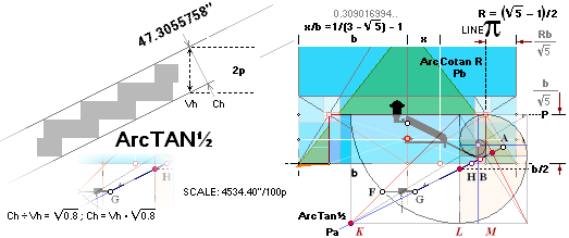
the scaled illustration: 1.08² ÷ (47.26 ÷ [2p(4534.40’’/100p)/2 • √0.8 = 40.55690655] =1.165276251) = 1.000964363. With a
1.000000000 match the Petrie measured Ch = 47.26” value becomes 47.3055758’’:
inside the Petrie associated tolerance. Meaning: The construction might as well
have been ordained from the 1.08² numerical operation. As the results are OK
within the Petrie advised tolerances, we cannot disprove the existence of a
matching building plan.
Vh = (4534.40’’/100)([108 = 2•3•18]/100)²
THE SCALING PRECISION
Summing Components VALUE IN FifthResult ¦
EntrancePassageAngle
¦ SecondResult
47.3050516137’’ ¦ 47.31
Result: Equation’s calculated value
using Resolution 217 recurring numeric constants:
2(4534.40/00)([108/2]/100)²√0.8 =
e=ChTUNNEL 47.3055758’’descending tunnel parallel
height
(4534.20/100)(108/100)²√0.8
= 47.3034892787’’ ¦ 47.30
rJCR scaleTest: 47.31’’ (no tolerance) ; approved. 99.8943141 % match. [ ±
0.04’’ = ±1.016 mM ]
Petrie
measure: 47.26’’ (± 0.17’’) ; highest 47.43, lowest 47.09 ¦ deviation:
0.0455758’, = 0.05”.
PetrieCH6.32.r56: ”
entrance passage angle at mouth 26°29’ ± 1’, entrance passage height 47.26”.
No specified tolerance in that
quote. Petrie’s text above the quoted (r32, see PetrieQUOTE19th)
specifies ”mean doorway height .. 37.67 ± .17”; Adopting a 47.26’’ ± 0.17’’, our (numeric) 47.3056 is
OK (+0.0456). The result is certified through another approach on the same
result (see Second result and more precisely the Fifth
result).
Difference rJCR – PETRIEm = 0.0455758’’ — well
within an adopted ± 0.17’’ tolerance.
Ch = 2p(4534.40’’/200p)(108/100)² · √0.8 ; uses
2•3•18=108 from Resolution 217.
=
47.3055758’’ ; CorridorHeight
108/100 = 2 · 3 · 18 / 100 = 27/25 = 3³ / 5²
Conclusion:
Petrie verified Entrance passage Height
Application Example:
See (Second
result)
HOW PETRIE
CALCULATED THE ENTRANCE
Comment:
IF we were
dependent on Petrie’s measured half Pyramid base bPETRIE =
4534.40’’ ± 0.25’’ ONLY, the above reckoning would only be »a regular result
from robbing on Petrie’s scaled Pyramid». We would not get any independent
credit for such a theft. As the bPETRIE 4534.40’’ as such however now (Jan2024)
has found a whole number Resolution217 independent solution with
a safe rJCIRCLE related match 99.9999832% —
using recursive constants, the being used on multiple sites — we are no longer
bound by Petrie’s measures. Resolution217 allows a claiming status of a direct
definition of the Petrie half Pyramid base INCH measure — in turn from the (MiUNIT)
numerical operation
rJ/100R√16000
= 0.025400718 an automatic 0.0254 M unit if so rounded on the
Planck Dmax mJ constant in our rJCIRCLE. Our
1 Inch = 0.0254 Meter definition.
So the InchMeter
UNIT adoption is proven, by arithmetics, independent of Petrie’s results —
rather as their definition. We will see that it is so by the Petrie measured
details.
Explain Resolution
217: FIRSTex
Petrie CH6 22 (The
possible 27.58’’¦27.48’’ factor, IntroTEF):
[all four corners with different vertical
ground socket sets between 23.0-39.9’’ below Petrie’s pavement].
After having used the bPetrie
pyramid data, resulting in an ideal height difference hDIFF between PetrieCR
and rJCR of 27.48’’, we made a simple numerical test:
Testing the rJCR basic CHEOPS
RECTANGLE bh=h2 GoldenSection
Pyramid parameters b 2b h d x r P P/2 P/r k R k0
on a division with h – hPetrie¦CR
=27.48’’ (27.482385374) gave
the results: 165.77911 331.55821
210.87428 268.23623 51.22856
h=198.572154778 M ¦ r ¦ ![]() ¦ 217.00767 74.13867
37.06934 284.46590 0.02249
0.06244. No other basics.
¦ 217.00767 74.13867
37.06934 284.46590 0.02249
0.06244. No other basics.
Reversing the revealed »x.00
y» reckoning yields: (as it so has happened: 7 and 31 are primes (the 4th and 11th): 7 · 31 = 217 = 116 + 101 = 108 + 8 + 101: The7):
hDIFF = (r¦rJ)/217 = 27.483356608’’ = 27.48’’
; [h – r/217]rJ · √R
= 4534.399236463; compressed:
h¦rJ – hDIFF = h![]() ¦PetrieCR = 5767.844927523
= »5767.85»’’*
; b
¦PetrieCR = 5767.844927523
= »5767.85»’’*
; b![]() PETRIECP¦CR = h
PETRIECP¦CR = h![]() ¦PetrieCR√R = 4534.399236463 = 4534.40’’.
¦PetrieCR√R = 4534.399236463 = 4534.40’’.
4534.40/4534.399236463 = 1.000000168, inv. 0.999999832.
* 5767.845898757’’
/ 5767.844927523 = 1.000000168, inv, 0.999999832 = 99.9999832%.
Petrie’s (Petrie CH6 22) bPetrieCP¦CR = 4534.40’’
(±0.25’’) appears directly — can be calculated OR WAS SO DELIBERATELY SELECTED
from the rJ GoldenSection (r) Cheops
Rectangle.
— See how the crucial hDIFF
(27.48’’) exposes a possible direct insight into the pyramid planning construct
in THE
UNITS: How bPETRIE 4534.40’’ is determined from rJCR with no
less precision than 99.9999832%. That given, the whole plan is given in
principle.
———————————————
See wider in
CALTEP ¦ TheMiUNIT ¦ Explaining Golden Section
Pyramid Agents
AppendixResolution217 ¦ RITa ¦ EARTHrJCIRCLE ¦ EARTHrJCIRCLEequation ¦ rJ ¦ bPetrieDetermination ¦ Resolution217 ¦ ChEX ¦ FirstResult ¦ FirstEX ¦ Res1 ¦ EXPLAINResolution217 ¦ Star1 ¦
THE 4 rJCR PYRAMID AGENT’S BASIC DATA
PetrieCP ♦ PetrieCR ♦
Agent16 ♦ Agent58
DATAPetrieSOURCE: PetrieSOURCES ¦ PetrieQUOTES — detailed 2’’ decimal
Petrie data specifications used to refere and certify the rJ Cheops description
THE PYRAMIDS AND TEMPLES OF GIZEH,
William Flinders Petrie 1883 — W. M. Flinders Petrie 1883 — @INTERNET Ronald
Birdsall, 2003-14
Petrie CP Cheops Pyramid — the
original (1881-1883) Flinders Petrie group measured basic Cheops Pyramid Values
—————————
|
PetrieCP: our tourist version |
° |
= |
51.866666667 |
|
|
|
|
° ’ ’’ |
= |
51.52000000 |
2’ |
|
measured/estimated |
|
|
|
|
INCH2dec |
±tol’’ |
METER |
|
|
|
b |
= |
4534.40 |
115.173760000 |
measured PetrieCH6section25 |
||
|
2b |
= |
9068.80 |
0.50 |
230.347520000 |
measured |
|
|
h |
= |
5776.00 |
7.0* |
146.710400000 |
measured/estimated |
|
|
d |
= |
7343.23 |
— |
186.517925307 |
measured |
|
|
x |
= |
1404.41 |
— |
35.672082653 |
not connected |
|
|
r |
= |
5938.81 |
— |
150.845842653 |
not connected |
|
|
P |
= |
2027.05 |
— |
51.487136856 |
not connected |
|
|
P/2 |
= |
1013.53 |
— |
25.743568428 |
not connected |
|
|
P/r |
= |
0.341322876 |
— |
0.341322876 |
not connected |
|
|
k |
= |
7786.26 |
— |
197.771051527 |
not connected |
|
|
R |
= |
0.617494323 |
— |
0.617494323 |
not connected |
|
|
k0 |
= |
— |
— |
— |
not connected |

*CheopsATLAS.htm#PCH6s25
— Petrie’s quote (high uncertainty)
-------------------------------------
Petrie CR — the ideal Flinders
Petrie group measured Golden Section Cheops Rectangle Pyramid
—————————
|
PetrieCR: featuring Chepos Rectangle |
° |
= |
51.827292373 |
|
|
aTan(1/√R) |
|
° ’ ’’ |
= |
51.49382525 |
2’ |
|
||
|
|
|
INCH2dec |
±tol’’ |
METER |
||
|
b |
= |
115.173760000 |
¦ r(3–√5) ¦ h√ (–1+√5)/2 =
h√R |
|||
|
2b |
= |
9068.80 |
0.50* |
230.347520000 |
|
|
|
h |
= |
5767.85 |
0.32* |
146.503285828 |
√ bd |
|
|
d |
= |
7336.81 |
0.40* |
186.355058292 |
√ b² + h² ¦ r(–1+√5) ¦ b/R |
|
|
x |
= |
1401.21 |
0.08* |
35.590649146 |
r – b |
|
|
r |
= |
5935.61 |
0.33* |
150.764409146 |
(d+b)/2 ¦ r=1
¦ (b/R + b)/2 = b(1/R + 1)/2 |
|
|
P |
= |
2027.85 |
0.11* |
51.507271317 |
b/(R+1/R) = b/√5 |
|
|
P/2 |
= |
1013.92 |
0.06* |
25.753635658 |
|
|
|
P/r |
= |
0.341640786 |
— |
|
2/(R+1/R)(1/R + 1) |
|
|
k |
= |
7780.73 |
0.43* |
197.630493458 |
b·k0 = √ b² + (d–P/2)² |
|
|
= |
0.618033989 |
— |
|
b/d = [–1+√5]/2 |
||
|
= |
1.715933329 |
— |
|
√ 1 + (½ +2/√5)² |

*±0.50’’/9068.80’’
× INCH2dec’’ = ±0.tt’’ — as adopted from Petrie’s standard Half
Pyramid base 4534.40’’ tolerance ±
0.25’’
-------------------------------------
rJ CR — the (Nov2017) TNED/Planck/Dmax/EarthMass
discovered Golden Section Cheops Rectangle Pyramid.
4556.01: It is
the rJCIRCLE CheopsRectangle (Cheops Pyramid)
original (k = 198.572154778 M) with b=k/k0=4556.01’’.
—————————
|
rJ CR: rJCIRCLE:s
Cheops Rectabgle |
° |
= |
51.827292373 |
|
|
aTan(1/√R) |
|
° ’ ’’ |
= |
51.49382525 |
2’ |
|
||
|
|
|
INCH2dec |
±tol’’ |
METER |
||
|
b |
= |
0.25* |
115.722535004 |
¦ r(3–√5) ¦ h√ (–1+√5)/2 =
h√R |
||
|
2b |
= |
9112.01 |
0.50* |
231.445070008 |
|
|
|
h |
5795.33 |
0.32* |
147.201338417 |
√ bd |
||
|
d |
= |
7371.77 |
0.40* |
187.242994901 |
√ b² + h² ¦ r(–1+√5) ¦ b/R |
|
|
x |
= |
1407.88 |
0.08* |
35.760229948 |
r – b |
|
|
r |
5963.89 |
0.33* |
151.482764953 |
(d+b)/2 ¦ r=1
¦ (b/R + b)/2 = b(1/R + 1)/2 |
||
|
P |
= |
2037.51 |
0.11* |
51.752690960 |
b/(R+1/R) = b/√5 |
|
|
P/2 |
= |
1018.75 |
0.06* |
25.876345480 |
|
|
|
P/r |
= |
0.341640786 |
— |
|
2/(R+1/R)(1/R + 1) |
|
|
k |
7817.80 |
0.43* |
198.572154778 |
b·k0 = √ b² + (d–P/2)² |
||
|
= |
0.618033989 |
— |
|
b/d = [–1+√5]/2 |
||
|
= |
1.715933329 |
— |
|
√ 1 + (½ +2/√5)² |

*±0.50’’/9068.80’’
× INCH2dec’’ = ±0.tt’’
-------------------------------------
0.698052589 M
27.482385374’’ ; 27.48’’ (±0.32’’)
Petrie
CR¦b58 — an actual tolerated Flinders Petrie group
measured Golden Section Cheops Rectangle Pyramid —
»Agent58»
PetrieCR¦b58: INSIDE PETRIE CR — b associated: inside
PetrieTolerances ± 0.25’’ from nominal 4534.40’’
58R√1600 = 4534.196575969’’,
= 4534.20’’ — THE PETRIE SUFFIXES here HAVE NO rJ ASSOCIATED.
See also MiUNIT.
|
PetrieCR¦b58: tolerated PetrieCR
version |
° |
= |
51.827292373 |
|
|
aTan(1/√R) |
|
° ’ ’’ |
= |
51.49382525 |
2’ |
|
||
|
|
|
INCH2dec |
±tol’’ |
METER |
||
|
b |
= |
4534.20 |
115.168593030 |
¦ r(3–√5) ¦ h√ (–1+√5)/2 =
h√R |
||
|
2b |
= |
9068.39 |
0.50* |
230.337186059 |
|
|
|
h |
= |
5767.59 |
0.32* |
146.496713341 |
√ bd |
|
|
d |
= |
7336.48 |
0.40* |
186.346697958 |
√ b² + h² ¦ r(–1+√5) ¦ b/R |
|
|
x |
= |
1401.14 |
0.08* |
35.589052464 |
r – b |
|
|
r |
= |
5935.34 |
0.33* |
150.757645494 |
(d+b)/2 ¦ r=1
¦ (b/R + b)/2 = b(1/R + 1)/2 |
|
|
P |
= |
2027.75 |
0.11* |
51.504960577 |
b/(R+1/R) = b/√5 |
|
|
P/2 |
= |
1013.88 |
0.06* |
25.752480289 |
|
|
|
P/r |
= |
0.341640786 |
— |
|
2/(R+1/R)(1/R + 1) |
|
|
k |
= |
7780.38 |
0.43* |
197.621627281 |
b·k0 = √ b² + (d–P/2)² |
|
|
= |
0.618033989 |
— |
|
b/d = [–1+√5]/2 |
||
|
= |
1.715933329 |
— |
|
√ 1 + (½ +2/√5)² |
Tolerance aspect:
*±0.50’’/9068.80’’
× INCH2dec’’ = ±0.tt’’
-------------------------------------
h DIFF
rJCR – PetrieCR¦b58:
0.704625076 M
27.741144740’’ ; 27.74’’ (±0.32’’)
Petrie CR¦b16 — same as Agent58 Golden Section Cheops Rectangle Pyramid but with
its pyramid base rJ-associated —
»Agent16»
rJ CR¦b16: INSIDE rJ CR — rJ associated: inside rJ
Cheops tolerance ± 0.25’’ [ extracted preference from Petrie’s nominal 4534.40’’ half
Pyramid base ]
rJ = 7817.80’’ = 198.572154778 M ¦ rJ’ =
7817.58’’ = 198.566539706 M ¦ rJDIFF = 0.221065826’’ = 0.005615072 M
100R√1600 =
7817.580303394’’ = 198.566539706 M
= rJ’ ¦ b’ = rJ’/k0
= (100R√1600)/√[(2/√5
+ ½)² + 1] =
4555.876483882’’= 4555.88’’ : — THE PETRIE SUFFIXES HAVE an
ASSOCIATED rJ .
See also MiUNIT.
|
PetrieCR¦b16: MiUNIT calculated rJCR
version
MAIN CONSTRUCTION PLAN PYRAMID AGENT |
° |
= |
51.827292373 |
|
|
aTan(1/√R) |
|
° ’ ’’ |
= |
51.49382525 |
2’ |
|
||
|
|
|
INCH2dec |
±tol’’ |
METER |
||
|
b |
= |
4555.88 |
115.719262691 |
¦ r(3–√5) ¦ h√ (–1+√5)/2 =
h√R |
||
|
2b |
= |
9111.75 |
0.50* |
231.438525381 |
|
|
|
h |
= |
5795.16 |
0.32* |
147.197175970 |
√ bd |
|
|
d |
= |
7371.56 |
0.40* |
187.237700186 |
√ b² + h² ¦ r(–1+√5) ¦ b/R |
|
|
x |
= |
1407.84 |
0.08* |
35.759218748 |
r – b |
|
|
r |
= |
5963.72 |
0.33* |
151.478481439 |
(d+b)/2 ¦ r=1
¦ (b/R + b)/2 = b(1/R + 1)/2 |
|
|
P |
= |
2037.45 |
0.11* |
51.751227536 |
||
|
P/2 |
= |
1018.72 |
0.06* |
25.875613768 |
|
|
|
P/r |
= |
0.341640786 |
— |
|
2/(R+1/R)(1/R + 1) |
|
|
k |
= |
7780.38 |
0.43* |
198.566539706 |
b·k0 = √ b² + (d–P/2)² |
|
|
= |
0.618033989 |
— |
|
b/d = [–1+√5]/2 |
||
|
= |
1.715933329 |
— |
|
√ 1 + (½ +2/√5)² |
Tolerance aspect:
*±0.50’’/9068.80’’
× INCH2dec’’ = ±0.tt’’
-------------------------------------
hDIFF
PetrieCR¦b16 – PetrieCR¦b58:
0.700462629 M
27.577268865’’ ; 27.58’’ (±0.32’’)
From THE Mi-UNIT and the
following rJ-CIRCLE connections
rJ/100R√16000
= 0.025400718 an automatic 0.0254 M unit if so rounded on the
Planck Dmax mJ constant
√16000
= 5 · 2 · 2 · 2 · √2 · √5 = 5 · 8 · √2 · √5 = (58
– 18)
· √2 · √5 = 40√10 = 5 · 8 · √10. All Golden Section terms.
also follows the two Cheops
Rectangle associated Pyramid agents b58 and b16
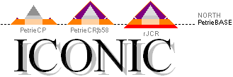
See the specific basic Pyramid
data in PetrieCP, PetrieCR, rJCR,
Agent58
and Agent16.
The basic Golden Section factors
√16000
= 5 · 2 · 2 · 2 · √2 · √5 = 5 · 8 · √2 · √5 = (58
– 18)
· √2 · √5 = 40√10 = 5 · 8 · √10. All Golden Section terms.
define these different agents
through the Mi-UNIT
definitions with their specific corresponding bPETRIE (4534.40±0.25)’’
value and its Petrie given tolerance. As such, and only as such, these Pyramid agents
are legimit consultants in the work aimed at deducing the Petrie measured
values from them — or not at all. It is all started from The
rJCIRCLE.
— See further a first detailed
example in CALCULATING THE Petrie values of the Cheops PYRAMID
xyENTRANCE.
PyramidData
¦ PetrieCP ¦ bPetrieTol ¦ PetrieCR ¦ TolASP ¦ rJCR ¦ rJCRtab ¦ rJCRb ¦ hrJ
¦ rrJ ¦ kFACTORrJ ¦ hDIFFmain ¦ Agent58 ¦ Agent16 ¦ Pref
¦ CalTePEM
ExplainingGSPA: METHOD ¦ CalculatingThePetrieMeasures
EXPLAINING THE DIFFERENT GOLDEN SECTION
CHEOPS
RECTANGLE MATHEMATICS bd=h2 PYRAMID
AGENTS
Explain — HowSTART — PROVING THE
CONTRACTED CONSTRUCT
While Petrie’s Cheops measurement (PetrieCP) have no fix and stable preference except the
Petrie measured Cheops Pyramid base (4534.40’’ ± 0.25
¦ PetrieCH6.s24) and his mentioned mean staircase masonry slope (aver. 51° 52’ ± 2’ ¦
@North 51° 53’ 20’’ ± 1’), the two new testing envelopings PetrieCR
and rJ¦CR
— within the Petrie given tolerances,
otherwise we’re smoked — do have such properties: Same visual (GS) Ideal Golden Section Cheops Rectangle bd=h² pyramid.
Only slightly different height from same top (hDIFFmain).
What does that situation
suggest?
The situation suggests that
IF the pyramid was SO intended — if, and only if — these two solid preference
guiders and a marker (based on a careful original planning) WILL define a clear
reference where Petrie’s measurement WILL coincide — practically excellent
perfect. In other more clear words: Petrie’s measured values can be calculated exactly from the GS
(resonant) matrix — within
Petrie’s given tolerances — or not at all. That will be our test.
— We have already seen (EARTHrJCIRCLE ¦ rJ-CIRCLE) that there (already) is a profound VISUAL fit in
the simple geometric paragons.
— But how close is it, and what can it clarify and elucidate?
General method:
We seek SIMPLE (»don’t get overly creative».. or: do so, and see
where it leads ..) whole number solutions (as advised by the GS-body —
compare Resolution217.
Explain more in detail:
While all of the Petrie measures
pertain to »the upper pyramid»
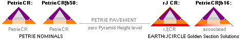
Upper pyramid icons left, their
half Pyramid bases — have Petrie’s assigned tolerance ± 0.25’,
respectively the original bPetrie
4534.40’’ and the defined and related associated Agent58:s
4534.20’’.
The upper Pyramid Icons relate the Petrie
pavement (Pyramid
Coordinate System) preference.
The lower Pyramid Icons relate also the
Petrie pavement preference, but have a slightly broader and lower situated base
(due to the testing EARTHrJCIRCLE, the rJ
factor as the related k-factor); these two lower
also have a tolerance aspect as here adopted from the Petrie half Pyramid base
standard ± 0.25’’; as after the Tolerance Aspect length ± 0.43’’ on the
rJ distance. However, their rJ-difference is only 0.221065826’’ — so safely
still within the testing Petrie advised more narrow half Pyramid tolerance.
the one and only possible
original building plan — if at all —
(the actual construction DRAFT
AND PRECISE MATHEMATICAL DRAWING)
must relate to the slightly
larger testing EARTHrJCIRCLE Golden Section Cheops
Rectangle Mathematics’ rJCR pyramid slightly higher, lower
founded rJCR pyramid.
— Everything else is out of the
question.
— Why is that?
— The only Pyramid Agent capable
of defining (Resolution 217) a close (99.9999832%)
match to the Petrie specified half Pyramid base 4534.40’’, is,
what we know, the EARTHrJCIRCLE Cheops Rectangle Golden Section Matrix System
equivalent. So, the potential constructors would have that premise for us to
deduce: Petrie’s base accurately defined — along with a corresponding rJCIRCLE
high precision numerically related MiUNIT 1 INCH = 0.0254 M. Without these
preferences, the Petrie measured comparing calculated data will not respond.
Not even close.
— Why the two Pyramid agents?
As stated: Without a bPetrie
4534.40’’ definition we’re done. The only one here known preference (Resolution
217) to realize that is the slightly higher/deeper — same top — Cheops Rectangle Golden Section Pyramid
— having the k=rJ-circle radius: the EARTHrJCIRCLE.
Based on that premise, an assisting Agent58 appears
related and deduced from the constants with a b-value within the bPetrie
4534.40’’ tolerance ± 0.25’’: the Agent58 (4534.20’’). It assists a rJCR spouse
Agent16
in presenting all the actual Petrie measured values — or, not at all. See MiUNIT,
CALTEP
and Resolution 217.
THE ROUTE IN THIS PRESENTATION BY CONCRETE EXAMPLES:
———————————————
Resolution217 ¦ DETERMINING/testing THE CORRIDOR HEIGHT
¦ How Petrie Calculated THE ENTRANCE
¦ The height of the 19th course
¦ CONSEQUENCES ¦ Determining the B point
Practicing a Horizontal Offset push — Petrie’s measured
tunnel crossing B-point defined
SHORT CASE HISTORY
CaseHistory:
THE SIMPLE TEST THAT STARTED IT ALL ..
2017: How it started ..
BASED ON THE 1881-1883 FLINDERS PETRIE THOROUGHLY MEASURED CHEOPS
PYRAMID
————————————————————————————————————————————
THE ideal geometrical Cheops
Pyramid 51.82729237° CHEOPS RECTANGLE (CR) connection
with its Golden Section geometry
paragon points out a significant (Queen's Chamber, k) center (P/2) on the inner
projected hollow Cheops Pyramid content.
———————————————
GoldenSECTION ¦ R = b/d = [–1+√5]/2 = 0.618033989
= 2/(1+√5)¦ P/2 :
P = b/[ R + 1/R ] = b/√5
Half pyramid base (b) and the
pyramid height (h) give the pyramid side (d) as
d = √ b²+h²
Raising d as a vertical (y),
removing the bottom P/2 distance, defines a k-center sloping triangle side
(rJ=k) as
k = √ b² + (d – P/2)²
with a tangent (k0)
k0 = √
1 + (½ +2/√5)² = (d – P/2)/b = k/b = 1.715933329 so that (b=k/k0)
k = k0b with the ideal
51.82729237° Golden Section paragon pyramid CR-value
k = 197.630493458 M receives a corresponding
51.86666667° Flinders Petrie (1881-1883) measured (no pyramid casing)
k = 197.771051527 M
On 1Nov2017 a simple calculating TNED test was made taking the neutron
circumscribed block density Dmax
on the present Earth mass (mJ
= 5.975 T24
KG). Its corresponding Dmax Earth radius r(Dmax) = (h/c0)(3mJ/π[mN]4)1/3
(constants in the link below) is
k = 6.62559E-034/299792458*(3*5.975E+024/(PI()*(1.0086652*1.66033E-027)^4))^(1/3)
¦ OpenOfficeCalc
k = 198.572154778 M = k(rJ)
k0 = 1.715933329 = √
1 + (½ +2/√5)² — fix geometric for the Golden Section bd=h²
CheopsRectangle
The difference in the computer screen scale is not visible: the
k-circle touches the (b.d)-rectangle corner on the exact pixel. Exactly. 172.411 pixels respectively 172.384 pixels. 172.
———————————————
We were on.
Further investigations deepened
the suggested connections.
— Main purpose: find any argument
to disclaim the suggested coherences. Still searching.
— WHILE we search, data is
collected and archived.
CaseHistory
¦ TST
¦ Rref
¦ rJref
¦ k0ref
TheUNITS: CaseHistory ¦ Resolution217
Arithmetical laborations on
seeking simple integer solutions — a simple construct
4534.399236463 ¦ bPetrie: 4534.40’’ ± 0.25’’
DETERMINING THE bPETRIE FROM THE rJ
THE UNITS — Why 217?
The short version: N = r/(H
– [h = bPETRIE/√R]) = 5963.89/(5795.33
– X¦2Decimals) = LowestDecimalPossible;
Highest possible decimal
precision — Highest Possible value HP:
X = r/(H
– [h = bPETRIE/√R]) ;
HP = 1/(X – INT[X]) ; HP =
130.3980100; HighestPossible
bPETRIE N = INT[X]
———— ———————
4534.20 215.0172581
4534.30 216.0078784
4534.40 217.0076688 bPetrie(PetrieCH6.25)
4534.50 218.0167574
4534.60 219.0352743
N = 217 = INT[X]:
PetrieCR versus rJCR only, no Pyramid Agents involved:
————————————————————
Unrelated numerical Solution — use the 4th and 11th prime product 7
· 31 = 217: = 109 + 108 = 109 + 2•3•18
bPETRIE = [h – r/217]rJ · √R
= 4534.399236463’’ = 4534.40’’.
= [5795.3282841311’’ —
5963.8883839628’’/217][0.7861513778] = 4534.3992364633’’
4534.40/4534.399236463 = 1.000000168, inv. 0.999999832: 99.9999832%
match.
hDIFF = (r¦rJ)/217 =
27.483356608’’ = 27.48’’ ;
— bPETRIE(PetrieCH6.25) = 4534.40’’ it is — ±
0.25’’.
WE SHOULD SAY — AS THE rJCIRCLE
VALUE COMES FROM ONLY NATURAL CONSTANTS — THAT WHATEVER APPEARS IN EXPLICIT
simple WHOLE NUMBER OCCASIONS IN THIS COMPLEX, IT IS APPARENTLY NOT A PRODUCT
OF A MANS HAND: »ARITHMETIC RESONANCE».
— NO MAGIC. NO MYSTERY. JUST LIFE. [ Which, of
course, is the greatest Magic Beauty Wonder of all ..].
WHAT WE KNOW: WITHOUT THE PRECISE rJCIRCLE
PREFERENCE, SUCH A HIGH SCORE RESULT IS IMPOSSIBLE: THE ENTIRE PETRIE DATA
MATCHING CALULATIONS IN THIS PRESENTATION DEPEND ON THAT PREFERENCE AND ITS
CONNECTION TO THE GOLDEN SECTION MATRIX SYSTEM.
Fully related answer — TheUNITS:
A bPetrie ————————————————————— a visual top BASE preference PetriePAVEMENT
from where to make Absolute [Petrie] measures.
The actual in real stone physical construct base.
B rJCR —————————————————————— absolute ground pyramid rJ CIRCLE Pyramid base: The DRAFT
construct:
Hidden from any direct visual investigation.
The TNED related physics and mathematics has no
representation in modern quarters:
The EARTHrJ CIRCLE
Dmax complex — Cheops Rectangle
PetrieCR versus rJCR only, no Pyramid Agents involved:
————————————————————
Explain — scenery ¦ rJCR results ¦ CALTEP :
The constructors took a numerical
scan (ending on a heigh offset: rJCR minus
PetrieCR, = 27.48’’ rounded from 27.483356608’’, CheopsATLAS2024.ods,
Tabell5 L22) — beginning from (B, fully related)
the rJPyramid bottom — advancing upwards to A, taking an A level pyramid base
only on a one decimal .x0 rounded inch value (the candidating bPetrie values
xxxx.n0).
Constructor’s Task to be solved:
— We have to set a standard
measuring platform above the rJCircle
Pyramid base — if any future tourists will have a chance of getting a deductive
clue to our construct, and what it proves. So:
— Is there, in the named scan, a
close to a whole number solution for a (hDIFF = B – A) slightly higher than our
basic B, so defining an ideal Petrie CR pyramid with a slightly less height
Top.A than our Top.B original rJ CR pyramid? (The overall result must be based
on one decimal rounded inch .x0-measure already from the start, see TheMiUNIT).
Result:
— Yes. There is such a whole
number: 217.
— See the (CALTEP)
bPetrie Determination:
[h – r/217]rJ · √R
= 4534.399236463’’
, = 4534.40’’:
X = r/(H – [h
= bPETRIE/√R]) ; HP = 1/(X – INT[X]) ;
HP = 130.3980100; HighestPossible
X =
217.0076688, INT[X] = 217 is our number.
A—B = 27.483356608’’ = 27.48’’
;
bPETRIE = 4534.399236463’’, = 4534.40’’ [future tolerance depends on
magnitude of erosion]
Precision:
99.9999832% — COMPLETELY IMPOSSIBLE
TO MISS, PROVIDED A SERIOUS APPROACH
4534.399236463/4534.40 =
99.9999832%.
4534.40’’ it is: see further MiUNIT:
rJ/100R√16000
= 0.025400718 an automatic 0.0254 M unit if so rounded on the
Planck Dmax mJ constant
1’’ = 0.0254 M. And so it is
[The actual Academic History behind this present equality is not further known
here].
— It was originally so determined
— unless the reader has found another solution, apparently factually —
impossible to miss with a future enough sophisticated (Petrie 1881+) optically
measuring instrumentation.
Consequential Mathematics (COMA — The Iterator): It is — or it isn’t.
Basic CPU handling routiines.
FIRST rJ-CHEOPS PROOF
Knowing we are safe and sound
on the right course
TheMiU: FirstPROOF
provided rJ-guided — in the Cheops
Rectangle-geometrics:
The rJCheopsRectangle contains a numerical »automatic
meter-(1)inch(0.0254)» unit
WITH A GIVEN 1 INCH = 0.0254 M DEFINITION AND THE
[1881] PETRIE DEFINED CHEOPS PYRAMID HALF BASE 4534.40’’ FROM Earth
rJCIRCLE AND the GOLDEN SECTION
MATRIX SYSTEM [the simple basic »Cheops Rectangle» connection
bd=h²], the rest of the unit system parameters become
automatically present through a universal physical MKSA system: Meter
Kilogram Second Ampere, independent of chosen numerical standard. That
vindicates, and certifies, a time [and culture] independent universal physical
standard. And so: it is proven.
Once a corresponding MKSA
unit system has been established, its internal quantities between different
standards will have no influence on the actual mathematical physics: any such
unitive Distance-Mass-Time-Current unit system will do.
THE MiUNIT — METER-INCH
rJ/100R√16000
= 0.025400718 an automatic 0.0254 M unit if so rounded on the
Planck Dmax mJ constant
2 · (7336.81’’=d=bPETRIE/R)
· R^18 = 2(4534.40’’/R) · R^18 = 2.539568549, rounded
2dec = 2.54 cM = 0.0254 M = 1’’;
2.54/(2· R^18) =
7338.059780201’’, = 7338.06’’ ¦ PetrieTol ±40’’ — 7336.81’; min 7336.41’’
— this 2.54 definition is
not valid.
— This was the (2017) original
onset to a suggested definition of the MeterInch Unit.
— However, as seen, its applied precision does
not really connect the Petrie specified tolerances. Instead,
as below (Jan2024), taking the view from the rJ-CIRCLE pyramid, the Petrie
tolerances are preserved — and a fully defined Petrie value explanation appears.
The numbers 18, 58 and 16000 are explained as partial factors inside the Golden Section R
= [(√5)–1]/2 geometrical mathematics:
One INCH (1’’) equals 0.0254
Meter (very close to rJ/100R√16000);
One Meter (1M) equals 1/0.0254 = 39.37007874’’.
Precision: 2.5400000 / 2.5400718 = 99.9972%, inv. 1.000028278.
The MiUNIT in this (Jan2024) 2020-complementary presentation
(not mentioned in the 2020 version)
rJ/100R√16000
= 0.025400718 an automatic 0.0254 M unit if so rounded on the
Planck Dmax mJ constant
is however still on the same profile as the one from the 2017 original:
2 · (7336.81’’= d = bPETRIE/R)
· R^18 ; b/R = d ; b/d = R ;
= 2(4534.40’’/R) · R^18 = 2.539568549,
rounded 2dec = 2.54 cM = 0.0254 M = 1’’;
Similar to 1/100th
= (6·18 + 8)/100 · R^18 · 40√10 =
0.025394546 ≈ 0.0254 (M) = 1 INCH
= (108 + 8)/100 · R^18
· 40√10 = 0.025394546 ≈ 0.0254 (M) = 1 INCH
= 116/100 · R^18 · √16000 = 0.025394546 ≈ 0.0254 (M) = 1 INCH
= (217 – 101)/100 · R^18 · √16000 = 0.025394546 ≈ 0.0254 (M) = 1 INCH
Primes 7 31
101:
7 • 31 — 101 =116
»Trivial»:
There is at least one special equivalence between a defined negative x-coordinate value (xBhigh -1499.7016293661’’ line crossing DeLIC trigonometric evaluation, tunnel cross) and a same positive value y-coordinate from the GS system matrix details
y = 1499.7016293661’’ = b16(½ + R3)/√5 = 4555.88(½ + 0.2360679775)/2.2360679775
= P(½ + R3) = 2037.4499030105 × (0.7360679775)
=
b16(1/2√5
+ R3/√5) as GS deduced [ Queen chamber
level / North Gallery level details]
SEE DETAILS IN The5.
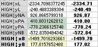
CheopsATLAS2024.ods Tabell2 A55+
— xBhigh — as calculated
through the common line crossing equation DeLIC.
— »Comparing a traditional solution with explicit Golden Section System
Matrix solutions» — example.
— Same value: [P=b16/√5](½ +
R³) = [b16 = 4555.8764838817](1/2√5
+ R³/√5)
— »Discovered by arithmetic
identification». [BUT IT IS TRIVIAL ..]
• Proof (trivial):
— Given the EarthrJCIRCLE MiUNIT 1’’ = 0.025400718 M, and the Resolution 217 definition of the Petrie measured Cheops Pyramid half
base 4534.40’’ with a 99.9999832% certain confidence, connecting the Golden Section matrix system solutions Cheops Rectangle bd=h² mathematics, it would be rather sensational if we could
find one Petrie measured detail in the Cheops Pyramid complex, that does NOT
apply. Don’t forget to update.
• Compare: EntrancePETRIE — proving the Golden Section connection.
These (additional Jan2024) results suggest that the
present academia idea of the origin of the Cheops Pyramid
based on the idea of a primitive
human technology : no PLANCK CONSTANT, no LIGHTSPEED
IN VACUUM, no EARTH RADIUS ON NEUTRON MASS DENSITY, no ATOMIC
MASS UNIT
will vaporize — be proven so — to exactly nothing.
We welcome a disclaiming — related — argument: Still searching ..
Consequential Mathematics — COMA
CONSTRUCTORS’ CONSIDERATIONS —
basic math:
Compare — 1’’ = 0.0254 M: whole number simple plan solutions
In the Golden Section GS numerical whole number operators
THERE IS »AN AUTOMATIC
Meter-INCH» UNIT IN A NUMERICAL (PREFERABLY WHOLE NUMBER) TREATISE ON THE
CheopsRectangle-GEOMETRICS — provided rJ-guided:
rJ/100R√16000
= 0.025400718 an automatic 0.0254 M unit if so rounded on the
Planck Dmax mJ constant
=
rJ/4000R√10
;
(rJ) = 100(0.0254)R√16000
; (rJCR¦b16)
=
198.566539706
M = (18·222+9/2)(0.0254)R√10 — »TheConstruct» ±0.5’’
-------------
rJmax = 198.57924 ¦ 198.5665 + 0.0127
rJ = 198.57215 .............. OK:
198.566539706 + 0.005615072 ¦ + 0.221065826 ’’
rJmin = 198.55384 ¦ 198.5665 – 0.0127
———————————————
CUV — The INCH factor: vindicating the two pyramid
levels, and the different units — within the Petrie tolerances
PROVIDED THE INCH UNIT WAS KNOWN .. OR VALUES WERE SO ROUNDED TO FORM
SUCH A METER UNIT 1 ’’ = 0.0254 M.
— We use the Petrie given whole
pyramid base (2× 4534.40 = 9068.80)’’ ±0.5’’ tolerance for the entire
(7817.80’’) rJ measure.
(±0.43’’ if we use the more
regular Petrie associated ToleranceAspect: max 198.583072, min
198.561228).
PetrieCR¦b58 = 58R√16000 = 4534.196576’’, = 4534.20’’ ;
16000 = [(PetrieCR¦b58)/(58R)]²
TheUNITS
¦ FullyRelated ¦ Explain217
¦ FirstPROOF
¦ MiU
¦ Special
¦ INCHref
¦ rJprim
Connecting
SECOND rJ-CHEOPS PROOF
![]()
The 58 factor .. 5 · 8 +
18 = 58 ..
b¦PETRIE/rJ = 4534.40’’/198.572154778
M ; apparently very close to 0.58:
=
0.580009620 ; rounded simple whole numbers only
=
58/100
=
(5 · 8 + 18)/100 ;
-------------------
b¦PETRIE = rJ(58/100)
=
4534.324794148’’ ; this value is within the Petrie tolerance 4534.40’’
± 0.25’’
-------------------
ALL VALUES INSIDE THE PETRIE GIVEN TOLERANCES ARE LEGIT AGENTS IN
FINDING THE PLAN OF THE BUILDING.
.. no ..... yes ..... no ..
TheUNITS ¦ bPETRIE 4534.40’’ ±0.25’’ ¦ max 4534.65’’ — min 4534.15’’
ExactComparingBasics — redundant
NOT REALLY A unit defining PROOF
------------------------
Given (PetrieCH6.25)
the Petrie INCH measuring standard with two rounded decimals, type half pyramid
base
bPETRIE = 4534.40’’, we (first GU ¦ MiUNITintro ¦ ExactComparing — MiUNITcomparing) found
2 · R^18
· (4534.40/R) = 2.539568549 ; rounded [ multiple = 1 ]
=
2.54 (cM) ; the rounding works exact up to multiple 11:
27.94’’
b/R = 4534.40/R = dPYRAMID ;
the ideal GoldenSection
Petrie pyramid wall length
=
7336.81’’ ; 186.355058
M — could not be Petrie
measured, no casing
Planck constant TNED related
NeutronSquare atomic mass defect top scale: 18 e: »The Entire Opening».
THE ENTRANCE:
Roof 18 (FLOOR 19) —
the stone masonry
(ActualCheops)
levels, see PETRIE BREAKS THE ENIGMATIC ICE.
Basically the main (rJCR)
mathematical »enigma» behind the inner details is solved here.
------------------------
4534.20 PetrieCR¦b58 58R√16000.0
= 4534.196576 ; = (rJ’CR¦b16=198.5665M) · 58/100 = (100R√16000)k0
4534.32 Petri2CR¦b58 58R√16000.9
= 4534.324098 ; = rJ(58/100)/0.0254
4534.20 PetrieCR¦b58 = rJ(58/100)/(rJ/100R√16000 = 0.025400718) ; = 58R√16000 = 4534.196576
4534.20 PetrieCR¦b58 4534.196576 ; = rJ(58/100)/0.025400718
√16000 = 5 · 2 · 2 · 2 · √2 ·
√5 = 5 · 8 · √2 · √5 = (58 – 18) · √2 · √5 =
40√10 = 5 · 8 · √10.
IN LABORATING WITH THESE TIGHT,
NEAR AND RELATIVELY CLOSE VALUES — ALL WITHIN THE PETRIE ADVISED TOLERANCES,
otherwise we are smoked — WE SEE THAT THERE ARE SEVERAL OFFERING OPENINGS IN
COMPARING AN IDEAL PETRIE GOLDEN SECTION PYRAMID PetrieCR WITH THE rJCR TNED-PLANCK-Dmax
RELATED DITTO.
THE PETRIE MEASURED CHEOPS PYRAMID BASE 4534.40’’¦ 4534.32’’¦ 4534.20’’ CAN
APPARENTLY BE CALCULATED FROM THE DEFINED (GS)
BASE GOLDEN SECTION PYRAMID’S CIRCUMSCRIBED (Queens chamber centered) rJ-CIRCLE —
THROUGH BASIC GS WHOLE NUMBER EXPRESSIONS ON THE COMPONENTS TYPE 2, 5 AND
√5 SOLUTIONS, (Powers of) THE GoldenSection
Constant R, AND ON A (most precise) GENERAL
METER-INCH DEFINED CONNECTION (ROUNDED BY A PETRIE INCH
STANDARD of 2 DECIMALS):
rJ/100R√16000
= 0.025400718 an automatic 0.0254 M unit if so rounded 0.0254
M = 1 INCH by the constructors of the building on the Planck Dmax mJ
constant rJ
THE FACTORS: 16
18 58
¦ The58 ¦ bPETRIE ¦ The18 ¦ The16
CALTEP: ChEX
— CALCULATING THE PETRIE VALUES
|
CheopsATLAS2024.ods Tabell2 A1+ 28Jan2024 WE EXPLAIN
AND FOLLOW THE RESULTS IN THIS PRESENTATION
exemplified 14 FIRST DIRECT
CALCULATED PETRIE VALUES BASED ON PYRAMID
AGENT16 |
PROVING GS CHEOPS PYRAMID GOLDEN SECTION MATRIX SYSTEM One single independent triangular trigonometric
connection
explains how bPETRIE 4534.40’’ ± 0.25’’
PETRIE CHEOPS PYRAMID MEASURES UNITES GOLDEN SECTION MATRIX SYSTEM MATHEMATICS
CALCULATIONS exemplified [14] FIRST DIRECT CALCULATED PETRIE VALUES BASED ON PYRAMID
AGENT16 — rJ’ = 100R√1600 = 7817.580303394’’ = 198.566539706
M AGENT16 b’ = rJ’/k0 = (100R√1600)/√[(2/√5 + ½)² + 1] = 4555.876483882’’= 4555.88’’ TROUGH THE PETRIE PYRAMID HALF BASE DEFINING RESOLUTION
217: 7 • 31 = 217
= 116 + 101 = 108 + 8 +101 = 2•3•18
+ 109[PRIME] bPETRIE = [h – r/217]rJ · √R = 4534.399236463 ¦ = 4534.40’’ =
[5795.3282841311’’ — 5963.8883839628’’/217][0.7861513778] = 4534.3992364633’’ bPETRIE =
[b/√R – b(1/R + 1)/(2·217)] ·
√R bPETRIE =
b[ 1 – (1/R + 1)(√R)/(2·217)] = 4534.399236463’’; match to
Petrie’s 4534.40’’: 99.9999832% b = rJ/k0 × 0.0254 ; rJ = 198.572155
M = = 6.62559E-034/299792458*(3*5.975E+024/(PI()*(1.0086652*1.66033E-027)^4))^(1/3)
¦ OpenOfficeCalcCELLcode MiUNIT: rJ/100R√16000
= 0.025400718 selected rounded unit: 1 INCH = 0.025400000 M It is fundamentally doubtful the Ancient Egyptians knew this — without advanced support
from already enlightened. |
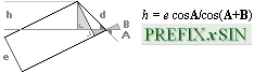
14 FIRST direct article linked CONSECUTIVE 14 —
RECURRING CONSTANTS AT THREE SITES — recursive simple whole numbers at several
sites: 108 = 2 • 3 • 18 ...
bPETRIE 4534.40 ¦ eCh 47.31 ¦ h 37.97 ¦ xG 4228.00 ¦ yG 1181.23 ¦ yA 668.15 ¦ Pangle 26° 31’ 17.5’’ ¦ Hangle 26° 28’ 58.55’’
¦ yB 172.90 ¦ xB 1570.70 ¦ yPG 1658.17 ¦ PC 4534.20 ¦
dSTEP 35.01 ¦ yKING 1693.17
¦ and further in this
presentation ..
ALL VALUES PCS WITH REFERENCE TO THE Pyramid North
base tip [ on a remaining casing stone ] PETRIE PYRAMID PAVEMENT:
y=0, with pyramid x-valuens
leftwards as negative extension [Petrie gave these positive values]
Beginning from the entrance —
ending ideally on the original casing, of which only a few base stones remain
today
CALCULATING THE PETRIE VALUES
CALCULATING THE Petrie values of the Cheops PYRAMID — Petrie’s 19th Course (Petrie Breaks The Enigmatic Ice)
PetriePyramidAngle:
CALTEP
Petrie, as quoted on the Cheops Pyramid Angle:
This Wikipedia Image has been
Sharpened and bottom [ merged ] contrasted
to enhance the contour and contrast [ and brightness ] in the
foreground parts.
|
WIKIPEDIA Cheops Pyramid [ 29Jan2024 ], Casing stones. Credit: Jon Bodsworth — egyptarchive.co.uk, Copyright |
” On the whole, we probably cannot do better than take 51° 52’ ± 2’ as the nearest approximation to the mean angle of the Pyramid, allowing some weight to the South side.”. PetrieCH6.24¦32 (WholeQuote): ” N face, by entrance passage mouth .. .. 51° 53’ 20’’ ± 1’ ” ; = 51.888888..°. The measurements of the Pyramid sloping angle only had the few remaining casing stones at the pyramid base. Petrie concludes (in giving a scale of weight/importance 0-10 for the different measuring parts): ” From all these
considerations the above weighting was adopted. It is clear that the South
face should not be included with the North, in taking the mean, as we have no
guarantee that the Pyramid was equiangular, and vertical in its axis.”. ; PetrieCH6.32.r56: ”
entrance passage angle at mouth 26°29’ ± 1’, entrance passage height 47.26”. PetrieCH6.32; ” mean doorway
height ¦ by measuring courses ¦ 37.94 ± .17”. |
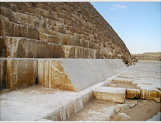
The Cheops Pyramid is a GS Golden Section
Matrix System Construction, no doubt — complex mathematics
and physics: Petrie’s measures GS calculated
RADIOCARBON DATING ON THE STONE MASONRY MORTAR SETTLES THE DATING ISSUE OF THE CHEOPS PYRAMID: 2 871 – 2 604 BC
THE WIKIPEDIA ARTICLE (Great Pyramid of Giza, alias our Cheops
Pyramid [the ancient Greek name]) has a section named Radiocarbon
dating. It states seemingly definite compelling evidence on the dating of
the stone masonry edifice, The article says
” Mortar was used generously in the Great Pyramid's construction. In the
mixing process ashes from fires were added to the mortar, organic material that
could be extracted and radiocarbon dated. A total of 46 samples of the mortar
were taken in 1984 and 1995, making sure they were clearly inherent to the
original structure and could not have been incorporated at a later date. The
results were calibrated to 2871–2604 BC.”
That information was not observed in this
production (2017+) until now (29Jan2024). The Wikipedia info above makes the presentation
of the calculating results in this, and the previous parts, even the more
interesting (extendingly extremely so very
much more: scenario below). The observed lapse (the Glaciation
Arguments) between — some at most 15 000 BC to 3 000 BC —
has now received a new, stronger attention (NorthAtlanticGlaciationQuotes);
A sophisticated computer controlled system of air borne
robots assembled the building in max 67 days. Tell me I’m a liar:
ATLANTIS GEOLOGY FRAGMENTATION urges a geologically
independent technological platform: The Atlans builds Large Tech Plants (LTP) situated in high
altitude, high above Earth ground: permanently parked (Consequential mathematics). Once established — autonomous
robotics maintenance: clean energy from E=mc² — the parking has no time limit: perfectly clean energy directly from
matter (TNED — basic fundamental knowledge NEVER INCLUDED IN PRESENT ACADEMIC COSMOLOGICAL IDEAS on the true nature of the atomic
universe: Planck constant, The
Neutron, knowing that
the atomic nucleus has an integrated current trap
THE NUCLEUS IS A CURRENT REGULATED DEVICE, which can dissolve the entire nucleus into clean mc² energy — as
sometimes happens ±e pair annihilation naturally in very strong atmospheric
discharge, see TGFintro). No physical
aspect can destroy That Culture, once realized. So, continuing the scenery on consequential
mathematics: LTP has smaller MigrationShips (MS), frequently visiting Earth
ground stations — for educational/mission, food and general material provision
and maintenance purposes. But: The non Atlantis Earth bound populations develop slow (and sees the Atlantis people as “gods” — while millennia passes); A growing egoistic, selfish and violent and power greedy mentality
develops among the less educated (THE UGLY SIDE OF THE INNER HUMAN NATURE THAT ONLY KNOWLEDGE CAN
CONQUER);
— Around some 5000ya (3000BC), the remaining Atlantis humans
(here named Atlans) realizes a coming end:
— Either we must destroy what is left of
our original high tech Atlantis. Or: give the E=mc² power tech machinery to
these lovely and very beautiful Earth ground bound growing bald forest cutting
Ego Suckers [Elucidating the noted situation]
— safely destroying humanity in total — which we won’t.
So: Let us build Reminders, Pyramids (Cheops Pyramid), for a far future
generation to sough out, in better times with better provisions for the love of
knowledge than this present of ours. After assembly: We set The Timer,
use our MS:s to go down to Earth ground a last time, leaving our LTP:s self
directing with our MS:s to self destroy on travelling into the Sun. We leave
not one itty bitty tiny no single trace of our High Tech culture — except in
the type Cheops Pyramid (TNED, rJCIRCLE).
— Now. reader (the final countdown): tell me I'm a liar —
all ancient history problems solved, down to the last atom, unless disclaimed.
— The
previous scenery (here in UH) has taken the view that the Pyramids already
stood there at the time of the beginning of the early Egyptian (and
Mesopotamian, and Sumer [and Indus]) civilizations. Some of the textbooks on
the early civilizations date the birth of the Egyptian (explained as ”sudden”)
civilization around 3 000 BC. Comparing Quotes in: CameronQuote,
SCENARIO, Early Civilizations.
— With ”The
Mortar Dating Argument”, a »Third Alternative» has opened, possibly (or not at
all); The specification ”2 871 BC” as a most remote date (provided exact dated)
would — then — (definitely) mark the actual (never
answered question on the) birth of the (often
sudden termed) beginning of the Egyptian civilization.
— ” But the troublesome is that it seems to have originated
suddenly.”.
— The Suddenly Aspect then takes an even more concrete contour on the most early mortar radiocarbon dating: not farther back than 2 900 BC. This presentation proves once and for all that the Egyptian culture or any other early human civilization as we know them, did not have the provisions in physics and mathematics to realize the geometry of the building — as it is exposed and unveiled in this general comparing test. So, by that standard unless disclaimed: Explaining History has taken a great leap ahead. Also suggesting: The Glaciation Arguments do urge a deeper investigation: NorthAtlanticGlaciationQuotes.
Testing method
— rJCIRCLE Golden Section caculated values versus Petrie measured
———————————————————————————————————
Similar to ChEX as explained in METHOD: Projecting the GS (GoldenSection) matrix geometrical body over our PetrieCP given measured Cheops Pyramid, we search/scan for structural congruities. It seems we have 7+1 (F) basic points (The7: KGLHBMA) on the GS body’s ARCtan½ line. Using the GS body fractal matrix circle-square alignments, we seek such aligning reference xy-points to calculate the values for all significant points. Then we take it further from there, testing if the results have any further lead — which they definitely have, indeed.
See the appending separate section in The7BEGIN and the following. We use a simple (DeLIC) line crossing trigonometric connection by which we receive xy-point values where crossing lines need a solution. Pyramid SCALE: Half Pyramid base (bPetrie 4534.40’’) equals 100 pixels. The following text will use and relate the results from The7.
EntrancePETRIE: PetriePyramidAngle
HOW PETRIE CALCULATED THE
ENTRANCE — we have no record of that, only the actual trigonometric
triangular mathematics
rJCIRCLE GOLDEN SECTION MATHEMATICS
INCORPORATES PETRIE MEASURES
SecondResult: — TheTHICK19th:
FirstResult ¦ CALTEP
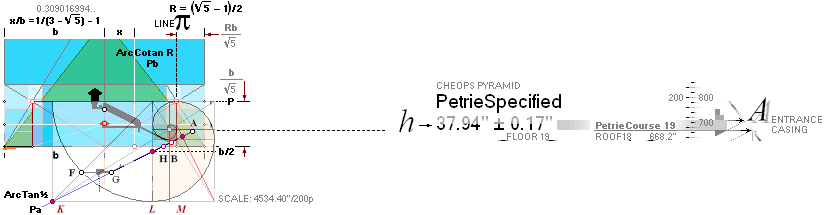
Equations in PREFIXxSIN ¦ AsDeduced
:
THE ONE SINGLE TRIGONOMETRIC CONNECTION
h = e cosA/cos(A+B)
¦ Deduction ¦ PREFIXxSIN
e = h cos(A+B)/cosA ¦ e/h = cos(A+B)/cosA ¦ cos(A+B) = (e/h)cosA
(h/e)cos(A+B) = cosA ¦ acos[(h/e)cosΣ°] = acos[cosA]
Σ° – (acos[(h/e)cosΣ°] = A°) = B° ; Σ° – B° = A° ¦ iterative solutions
cos(Σ°) – (e/h)cosA = 0 ; Σ° – A° = B° ¦ iterative solutions
UNITES PETRIE’S MEASURED CHEOPS PYRAMID WITH (GS)
CHEOPS RECTANGLE GOLDEN SECTION
MATRIX SYSTEM:
BUT NON THE LESS, EVERY PETRIE CHEOPS PYRAMID MEASURED DETAIL MUST BE PROVEN CONNECTED TO THAT MATRIX SYSTEM QUANTITIES — WITHIN THE PETRIE STATED TOLERANCES — BEFORE A TRUE AND GENUINE RELATIONSHIP CAN BE STATED AS REAL STEEL TRUE (C19thITERATED).
— »We are just warming up».
h = e cosA/cos(A+B) ¦ Using the ChEX result
e = h cos(A+B)/cosA ¦ e/h = cos(A+B)/cosA ¦ cos(A+B) = (e/h)cosA
eTUNNEL 47.3055758’’descending tunnel parallel
height, value fron FirstEX
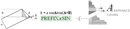
Illustration corresponding to Petrie’s PlateXI.4
![]()
” mean doorway height ¦ by
measuring courses ¦ 37.94 ± .17”;
Petrie Provisions measured e A B — measured h — never what we know mentioned as calculated
e = 47.26” (± 0.17)
A =
51° 53’ 20’’ @PyramidNorth, PetrieCH6.32.r56
B = 26° 29’ ± 1’ PetrieCH6.32e as quoted
h PETRIE h = 37.94’’ ± 0.17’’ PetrieQuote19th
” mean doorway height ¦ by measuring courses ¦ 37.94 ± .17”
rJCR Provisions calculated e
KNOWN A B Golden section
matrix system Cheops Rectangle math from bd=h² — calculated h
e = 47.31” ¦ 47.3055758’’
A =
51° 49’ 38.2525’’ = ARCtan(1/√R)
B = 26° 33’ 54.1842’’ = ARCtan½
h rJCR h = 37.97’’ ¦ 37.9658061814” — approved: within Petrie’s stated tolerance
CHECKING PETRIE’S SPECIFIED h THROUGH THE TRIGONOMETRIC EQUATION given eAB:
Course19th: ResSEC
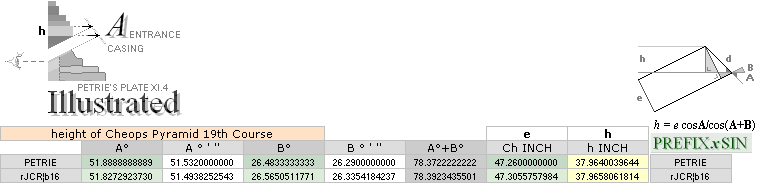
CheopsATLAS2024.ods Tabell1 A54+
The rJCR candidate
share values well accepted inside the Petrie given tolerances (± 0.17” quoted
below).
— With both angles AB known and the tunnel
height e the fourth horizontal parameter h can be calculated as
shown above by the trigonometric h-connection.
Given the fix metrics of course h and sloping
tunnel e, the connecting angles AB can have variable values
independent of the fix he quantity. As one set of these independent AB angles apparently
connects to the Golden Section Matrix system, a principle bound connection
already exists to any other he preserving AB set.
— However. Also
all other details of the edifice need be proven Golden Section matrix connected
by explicit alike mathematics — if a true definition will hold.
— But what we know: Petrie never mentions any
calculation of the h-parameter, only the statement
” mean doorway height ¦ by measuring courses ¦ 37.94 ± .17”
— It appears that Petrie does not use the triangular connection SecondResult at all. This we can settle by using the triangular equation in the following manner:
Σ° – (acos[(h/e)cosΣ°] = A°) = B° ; Σ°
– B° = A° ¦ iterative solutions
in PREFIXxSIN
— Inserting Petrie’s measured he values 37.94
and 47.26 together with Petrie’s stated descending tunnel angle B = 26° 29’,
allows us to iterate up the B angle value.
That is what a Petrie inevitably land surveying
trigonometric technique would have had to observe — Petrie’s corresponding
Plate XI as ”(CASING RESTORED)” —
![]()
in his corresponding and concluding statement (over
the above)
51° 53’ 20’’ ± 1’ (corresponding to Petries
specification on the North pyramid wall PetrieCH6.s24):
C19thITERATED: C19th
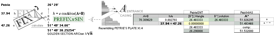
CheopsATLAS2024.ods Tabell2 Q19+ —
PROVING A never observed mathematical
PETRIE CONSOLIDATED CONNECTION TO the GS GOLDEN SECTION MATRIX SYSTEM
SOLUTIONS
— Iterative Method (Equation):
We add or subtract numbers to the A+B cell (with Enter after each change) with
purpose of nullifying the central yellow colored cell, as expressed.
The fixed input values are h/e and the Petrie tunnel angle 26° 29’ = 26
+29/60 degrees.
— The solution says 51° 49’ 34.66’’. Only 3.59 arc seconds from
score.
— The solution says 51° 49’ 34.66’’ — pretty much the GS
Golden Section Matrix Cheops Rectangle Casing Pyramid’s ARCtan 1/√R = 51°
49’ 38.25’’.
— Not at all Petrie’s 51° 53’ 20’’.
That proves that Petrie did not calculate his stated
casing angle, unless we have missed something. THE EQUATION AND ITS RESULTS PROVES, CERTIFIES AND
VINDICATES A GOLDEN SECTION SOLUTION — THAT APPARENTLY NEVER WAS OBSERVED BY
PETRIE.
This
author does not intend to question Petrie’s results. No way. The thing is that
we (»normal aces») in our time have immensely much more mathematical power aid
(computers) than the people around Petrie’s Cheops measuring, some year 1880.
Maybe the actual (iterative) trigonometric equation was not even
familiar — or perhaps inconvenient to use, or other reasons.
Petrie’s ”
The answer
has been already given in the list of determinations of the casing angle”
(should be the Weighted listing in PetrieCH6.s24),
” It requires an angle of slope of
51° 53’ 20’’ ± 1’ ; and this is so close .. that it conclusively
clenches ..”, radiates a for us unknown mathematical assurance.
That detail has not been observed earlier in this UH production (never so
calculated); The Petrie he values and his stated tunnel angle 26°
29’ (our deduced Hangle) apparently closely defines a direct 19th course Golden Section
connection, the trigonometric solution says.
C19thCHECKED: Ci

CheopsATLAS2024.ods Tabell1 A65+
— We can check the »never Petrie used trigonometric
equation» results more precisely as above in adopting the recent above
iteration result 51° 49’ 34.66’’ — a clear Golden Section Pyramid indication —
that apparently Petrie never used together with his measured e partner
47.26.
— Adopting directly the Golden Section Cheops
Rectangle mathematics A° = ARCtan 1/√R angle in the Petrie line and using
again the direct equation
h = e cosA/cos(A+B) with Petrie’s e =
47.26, we now get the Petrie
h = 37.94
comparable to the previous Petrie calculated h =
37.96 — with Petrie’s own stressed
and specified A° = 51° 53’ 20’’.
The mathematics holds — exposing that very small (0.03’’)
variations inside the Petrie (»almost huge») specified tolerances (here
± 0.17) have »devastating» consequences to The Quest Is or IsNot Golden Section
Pyramid associated — from Petrie’s given data. Concluding like this: it, a Golden Section system mathematics
association, is practically impossible to miss, provided using the
trigonometric mathematics. The 19th Floor it is. 18th Roof. (Petrie, breaking the enigmatic ice).
— Meaning: These (Ci) mathematics trigonometric equation examples, as they say, point out that Petrie’s data really do provide a definite connection to the Golden Section Matrix Pyramid system — through Petrie’s thoroughly described 19th course stone masonry (heB). The Petrie working group (1881-1883) apparently was shielded not familiar with from using its proving content — unless we have missed something. We definitely have no covering access to the archives, so we cannot say for sure. As already noted earlier, these are reserved for already Educated Cookies: no human right mentioning. Not one word. Cheops Pyramid is Cheops Rectangle bd=h². Disclaim.
Explain: C19th
A FIX h VALUE ”by measuring courses”
CERTIFIES — THROUGH THE CONNECTION
h/e = cosA/cos(A+B)
¦ PREFIXxSIN — A DIRECT PROVABLE LINK TO
THE GS GOLDEN SECTION MATRIX SYSTEM’S
CHEOPS RECTANGLE PYRAMID bd=h². MEANING:
— As the Course19th equative Petrie-GS-example shows, different angles have the (Petrie tolerance) same end station h-result: the mirror-angles have no decisive mandate :
— The building has a GS-associated PLAN at least there. It — the
plan, »the architect’s blueprint» — is different from the actual
construct which can be deduced from the plan (ContractedConstruct).
— »We are just warming up».
— In order to really proove the Cheops Rectangle
status of the Cheops Pyramid, we, hence, must find every single Petrie
measure, within its tolerance, to a regular Golden Section Matrix mathematics
calculation, or such system matrix identification. Every. However: The Resolution
217 has already provided us with the basic arithmetical MiUNIT
proof through the EARTHrJCIRCLE
value: the bPetrie 4534.40’’ half Pyramid base fundamentals
— with a certain 99.9999832% confidential match.
Dodge that one, if anyone can. Meaning: it is already standing there:
bPETRIE =
b[ 1 – (1/R + 1)(√R)/(2·217)] = 4534.399236463’’; match:
99.9999832%
b = rJ/k0
× 0.0254 ;
rJ = 198.572155 M
=
= 6.62559E-034/299792458*(3*5.975E+024/(PI()*(1.0086652*1.66033E-027)^4))^(1/3)
¦ OpenOfficeCalcCELLcode
MiUNIT: rJ/100R√16000
= 0.025400718 selected rounded unit: 1 INCH = 0.025400000 M
It is doubtful the Ancient Egyptians knew this —
without advanced support from already enlightened.
The first excercise from that outlook: Deduce the
actual e from the Golden section system. Please.
Explain eTUNNEL 47.3055758’’descending tunnel parallel
height
THE FIFTH RESULT:
Summing — compare FirstEX — Ch, corridor height numerically by Scale: 47.3055758’’
Vh = c = yATH + yBlimit + BUARM + (bOFFSET – 18)/2
= 52.8886555437’’ ¦ 52.89 , × √0.8 =
Ch = 47.3050516137’’ ¦ 47.31 ; 47.3050516137’’ ¦ Ch:1¦ 47.3055757984”
Compressed from GS
Golden section matrix
Cheops Rectangle rJCR system:
the constants appear recursively: Tunnel cross B,
Gallery ramp top PG, and Pyramid North entrance A
CheopsATLAS2024.ods Tabell2 A1+
BUARM = abs(xB¦A16
– xB¦A58)/2 ; B-point Upper Ascending ROOF
Mean average, or
=
3.5682917806’’ ¦ 3.57 ; »upper ascending ROOF averaged mean difference»
yATH =
2(yBhigh
– yBlow)
; same Bhigh intersecting
vertical on the ideal ARCtan½ sloping corridors
=
43.3696399875’’ ¦ 43.37 ; marker for decending and
ascending basic passage height determination
bOFFSET =
b¦A16 – b¦A58 ; the two Pyramid agents’ half
pyramid base difference
= 4555.876483882’’
– 4534.196575969’’
=
21.6799079131’’ ¦ 21.68 ; » the final sealing »:
yBlimit
: TunnelCROSS — absolute Construct Limit HBA floor:
yHangleBend = abs(xH – xB)tanHANGLE – yB
= -0.6338339337’’ ;
yPangleHend = abs(xG – 10R – xH)tanPANGLE + yG + n
= 3.6463097198’’ ;
yConB = yHangleBend
+ yPangleHend ; absolute HBA construct limit
floor base
= 3.0124757861’’ ;
d = 2.1323680500’’ ; basement G section details ¦
Construction
plan level G
D = [d/cos(PANGLE° + C°)] cos(C°) ; C° = ARCtan(1/√R)
= 1.7116318595’’ ;
SIO = n – D
; secure inspection offset — SIO
illustrated
= 1.0982940329’’
=
4.1107698190’’ ; PI-valueAlternative dependent ¦ 4.1112567233
18 = see MiUNIT ; as used — when it is offered
---------------------------------------
nHYPO = √ n2 + (n/2)2 = 3.1497590802’’ ; difference to pi = 0.00817’’ ¦ should be OK to use, inside margins
L =
| xG –
xA | · √ 1.25 ; xG — xA = d ; dHYPO = √ d² + [d/2]² = d √ 1 +
1/4 = d √1.25
= 4135.3383474429’’ ;
PANGLE° = ARCtan½ – ARCtan(nHYPO¦π/L)
= 26.5215239127°
= 26° 31’ 17.486086’’ ; slightly less than ARCtan½
Petrie = ” 26° 31’ 23’’ ± 5’’ ? ” ; PetrieCH7.36e as quoted
---------------------------------------
= 4.7753769413’’ ;
e = cTanPANGLE
= 2.3831554097’’ ;
d = eSinPANGLE ; PREFIXxSIN ¦ Construction plan level G
= 2.1323680500’’
LAH = 2yA√1.25 ; 2yA = xA
= 1487.7416175918’’ ;
HANGLE° = ARCtan½ – ARCtan(d/LAH)
= 26.4829296551°
=
26° 28’ 58.547’’ ; 2’ 18.94’’ less than
PANGLE
Petrie = 26° 29’ ± 1’ ; PetrieCH6.36e
as quoted
” (4) entrance passage angle at mouth 26° 29’ ± 1’ ”
Difference = 1.453’’ ; ARCseconds — well within Petrie’s
tolerance ± 1’
---------------------------------------
ACTUAL EXPLAINING FIGURES AND ILLUSTRATIONS — IN LINKED SECTIONS.
PetrieQUOTE19th: 2ndResult
” mean doorway height ¦ by
measuring courses ¦ 37.94 ± .17”;
—————————————————————————
Petrie gives a long description
of his method (Petrie Breaks The Enigmatic Ice)
![]()
in determining the descending
passage — with respect to its (projected) end on (the original, long ago lost)
Pyramid casing. The reasoning includes observations of several other similar
(nearby) pyramids, showing a similar edificial principle solution.
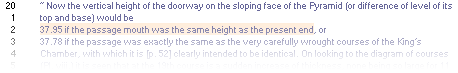
”..
the vertical height of the doorway on the sloping face ..” clearly exposes
the Petrie idea as the triangular hedABd
illustration suggests — unless we are deeply mistaken. Petrie gives the end
picture in his short table:
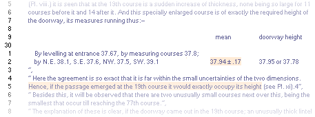
So, there shall be no doubt on what site Petrie is aiming at; 37.94 ± 0.17
it is:
![]()
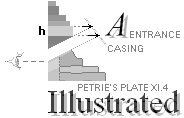
See further in ExplainA
CALTEP ¦ Num217REF ¦
PetriePyramidAngle ¦ RadioCarbonDating ¦ EntrancePETRIE ¦ SecondResult ¦ THICK19th ¦
EquationSecond ¦ ResultSecond ¦ Course19th ¦ EquationSecondITERA ¦ Stressed5153 ¦ C19thITERATED ¦ C19thCHECKED ¦ Explain19th ¦ FirstExercise ¦ PetrieQUOTE19th
Concerning Flinders Petrie’s
thorough Cheops Pyramid measures (1881-1883)
MENU — PROVING EXCELLENT CONCORDANCE BETWEEN
PETRIE’S MEASURES AND (GS)
rJCIRCLE-GOLDEN
SECTION MATRIX SOLUTIONS
—————
The TEN RESULTS link section namings (First .. Second ..
Tenth) is a rest from the first draft in this presentation,
exposing the
first ten results where Petrie’s measures concur with the Golden section
rJCIRCLE calculated values.
They are listed
below in a separate group.
—————
PREVIOUS ABOVE:
—————
RITa —
APPENDIX Resolution 217
EARTHrJCIRCLE —
Revisitring CheopsRectangle2017
— enhanced version Jan2024
Resolution217 — proving
Petrie’s Cheops Pyramid half base inch quantity
First — ChEX, first corridor height example
CALTEP — CALCULATING THE PETRIE VALUES
Second — 18th, TheTrigonometricEquation — PROVING
THE GOLDEN SECTION MATRIX SYSTEM PRESENCE IN PETRIE’S MEASURES
ALL THE FOLLOWING SECTIONS
-----------------------------------------------------------------------
The7BEGIN — preparing for Petrie value definitions: xyG
and xyA ¦ GpointParams
¦ FIRSTyxA ¦
BpontDetermination — preparing for Petrie value definitions: xyB ¦ xyBPetrie ¦ GSBsolutions
¦ DeLIC ¦ BupLowOrg ¦ Bupper ¦ BPco ¦ BPAL ¦ Blower ¦ CORIH ¦ LineCROSSxy ¦
xPAref ¦ xBhigh ¦ yBhigh ¦ ResultBpoint ¦
-----------------------------------------------------------------------
Height18 — HAS a Stage 1 ¦ SolutionA ¦ DIVA ¦ THEnFACTOR ¦ IdealAndConstructAngle
¦ nSymmetry ¦ PetrieROOF18
¦ THEn ¦ Npin ¦ ConfirmingPetrie19th
¦ ThirdResult ¦ rJCIRCLEverified
¦
y18ROOFcon ¦ EXTRECON ¦ HanglePangle
¦ CDetailsH18 ¦ ExtraCON ¦ nHYPO ¦ Rot125 ¦ PANGLE ¦ PetriePangle
¦ EighthResult ¦ dREF ¦ HANGLE ¦ PetrieHangle
¦ NinthResult ¦ ConPlanG
PETRIExA ¦ ExplainA ¦ RevisitingTheAngle
¦ PETRIExARelated
¦ INcon ¦ ConfirmedPetriePoints
— short summary¦
-----------------------------------------------------------------------
FormatingBUARM-yATH — COMPLETING the B POINT REGION
DETERMINATION — and its Casing Connectivity ¦
— SUBTERRANIAN TO CASE — nFACTOR — Hangle and Pangle — preparing definition of
Petrie’s B-POINT : the tunnel cross ¦ Stage 1
yATHcalc ¦ BUARM ¦ yATH ¦ yBarm ¦ yBlow ¦ yBlo ¦ bOFFSET ¦ yATHsymmetry
¦ TUNNELcross
¦
-----------------------------------------------------------------------
yPG ¦ BconnectingPG ¦ PetriePG ¦ yPGcalc ¦ PyramidCenter
¦
-----------------------------------------------------------------------
EPA — EntrancePassageAngle — SIO, yBlimitCALCULATION
— SIO: yConB yHangleBen + yPangleHend
PetrieTol017 ¦ yBlimitCALC ¦ yBlimit ¦ yHaBe ¦ yPaHe ¦ yConB ¦ Dsio ¦ SIO ¦ yBlimitALG
¦ PetrieBpointCalculated
¦ FourthResult ¦ yBPetrie ¦ xBPetrie ¦ xPetrieB ¦ CorridorHeight
¦ FifthResult
cLENGTH ¦ ChCORRIDOR — Ch2¦
TCC — THE CONTRACTED CONSTRUCT¦ TenthResult ¦ TranspositionPLANtoConstruct
— the tunnel cross ¦ ContractedConstruct
¦ ContractedConstructVerified
¦ ResultTunnelCross
¦ SeventhResult
¦ EXcontractedConstruct
¦ Course19thHeight
¦ SixthResult ¦
-----------------------------------------------------------------------
dSTEP — upper Gallery Ramp end ¦ dSTEPcalc ¦ yKING ¦ yKINGcalc ¦
-----------------------------------------------------------------------
TUNGAL — collective illustration, Tunnel cross
-----------------------------------------------------------------------
SIOillustrated — SECURE INSPECTION OFFSET
-----------------------------------------------------------------------
TheDpoint ¦ xyD ¦ EGSf ¦ ExplainDetails ¦ xyDalgebra ¦ The5 ¦ Compiled ¦
-----------------------------------------------------------------------
GalRES21Feb2024 — GALLERY RESOLUTION 2024 ¦ GalHeightIssue ¦
SmythTol ¦ GallerySouthWall
¦ GalleryAnglePETRIE
¦ TrigMETH ¦ PetrieHypoGAL
¦ GalleryRoofSlopingAngle
¦ GalRoofRampDetails
¦ GalleryRAMP ¦ PetrieGalRoofPros
¦ PetrieGalleryRoofDetails
¦
GalleryRoofInvest ¦ SawToothRoofing
¦ iDSangle ¦ NominalGalleryHeight
¦ GalForceConstruct
¦
-----------------------------------------------------------------------
Summing ¦ M74GS — ARITHMETIC
RESONANCES¦ PCS
— PYRAMID COORDINATE SYSTEM¦ Application ¦ PetriePlate9Issues
¦
-----------------------------------------------------------------------
GoldenSectionMatrixSYSTEM ¦ GSgeometry ¦ GSalgebra ¦ GScSMal ¦ GSbPnCHmal ¦ GSmaSeries ¦ GSPyramidMatrix ¦ GSgeometry ¦
-----------------------------------------------------------------------
VOOD —VERIFICATION METHOD¦ MethodSTRUCTURE ¦ METHOD ¦ NotesOriginal2017 ¦ CalCards ¦ Kalkylkort ¦ CONTENT ¦
-----------------------------------------------------------------------
THE TEN RESULTS — prior draft
edition to the above more compact
FirstResult — Parallel CorridorHeight e=Ch ¦ SecondResult —
19th course thickness h from e=Ch and an iterative trigonometric
equation ¦ ThirdResult
— 19thFloor 18thROOF height over pavement, y18thROOF ¦ FourthResult —
Petrie B-pointCalculated, xyPETRIE ¦ FifthResult — calculating e=Ch,
and c=Vh from further related recursive constants, summing c,
vertical Corridor height c, at the TunnelCross ¦
SixthResult — comparing h19th alternative results
solutions and their Petrie values, measured, as calculated ¦ SeventhResult
— A CONTRACTED CONSTRUCT ¦ EighthResult — Petrie verified Pangle ¦ NinthResult — Petrie verified Hangle ¦ TenthResult —
Transposition PLAN to Construct ¦
ADDITIONAL GALLERY DETAILS — already presented in part
[AND ARCHIVED] in the first 2020 version in CheopsATLAS.
This presentation partly uses links from that edition for reference (and archive).
Additional data on the so called Queen’s and Kings chambers (EQUALITIES) are tabled from the beginning in CheopsATLAS, comparing some of the foremost Petrie’s data with multiple Golden Section constant (R) values
— their differences, and how they match to Petries stated tolerances.
As of yet (Feb20247): not all
Petrie data have been Golden Section scrutinized in this production. Only the
foremost and most important in underlining the concurring quantities.
The7BEGIN: CALTEP ¦ METHOD ¦ GOLDEN SECTION
MATRIX SYSTEM
BEGINNING FROM FIRST AND SECOND
EXAMPLES
Beginning from the entrance —
ending ideally on the original casing, of which only a few base stones remain
today (ThePyramidAngle)
CALCULATING THE PETRIE VALUES — preparations
CALCULATING THE Petrie values of the Cheops PYRAMID — The7 Points with the xyENTRANCE
— »We are just warming up».
(Humanity needs energy for technology — clean energy: no Nature Raping — .. the whole aim behind UniverseHistory .. — if at all).
(.. it all began in the beginning of the 1960s, on a day with extremely heavy thunder .. in the eyes of a child .. ).
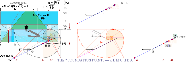
As simple as it is from the
Golden Section paragon matrix structure, almost directly the entire inner
layout of the Pyramid interior is given directly as above illustrated. The
basic ArcTAN½ line collect seven significant xy-points — apparently explaining
the whole construct plan.
The following expressions define
the first five K F G H A xy-points leading to The Petrie measures Pyramid
entrace data.
All line-points K G L H B M A have one and the same
simple elementary Golden Section ArcTan½ line angle 26°
33’ 54.18424’’ = 26.565051177°.
bn = bRn–1 — explained by detail in Golden Section
Matrix System
There is a whole lot of geometrical mathematics
calculating work to be done
in the rJ Cheops Rectangle/Pyramid Golden Section
complex — all ending on the 1883 Petrie measures — or not at all
GpointParams: CALTEP
ENTER — all values in Petrie standard inches
uses the pyramid agent Petrie CR¦b16 from Resolution217:
the rJ-associated b = (100R01600)/k0
= 4555.88’’ :
Gpoint-parameters
rJCR¦b16:
|
|
xK =
-6890.5863216062 = –(piLINE + b4 + b) ; piLINE = Rb/√5
¦ bn = bRn–1 See GSmatrixAlgebra
yK = -2518.4265808713 = – (b – P) ; P = b/(R + 1/R) = b/√5 ----------- xF = -5556.2009937255 = –(piLINE + b4 + b/√2) ; yF = -1184.0412529906 = –(b/√2 – P) ; ----------- xG =
-4221.8156658449 = xK + 2(b
– b/√2) ; working through the
aTan½ K.A line — all triagles related by 2 or ½ yG = -1184.0412529906 = yF ; ----------- xH = -1853.7331598636 = xG – 2yG ; yH = 0 ; ----------- h = b(cotanA° + cotanB°)–1
; TriangleConnection ; internal designations, not this figure connected yA = 665.3382779782 = –xH/(cotanA° + cotanP°) ; tanP° = 1/√R = yA/xA = xH/(2 + √R)
; The general R
connection gives a simplified triangle- equation xA = -523.0566039073 = –yA√R ; leftSTRETCHED from xy=0 -----------
;
rJ¦CHEOPSin ; original2007 |
|
|
|
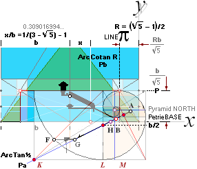
We repeat the same routine on the
Petrie CR¦Agent58:
Same equations, only beginning from
b = bPETRIE 4534.20’’.
The point is to make a final summantion on the G-point values.
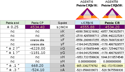
CheopsATLAS2024.ods Tabell5 W1 —
13Jan2024
The7BEGIN ¦ GpointParams ¦ FIRSTyxA ¦
BpointDetermination: xyBPetrie: x = 1517.80’’ ±
0.30’’ ¦ y = 172.90’’ ± 0.20’’, as quoted: — calculating constants, preparing
for Petrie value definitons
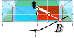
CLARIFYING THE PETRIE
MEASURED B POINT
THE SOMEWHAT TRICKY PETRIE
DESCRIBED CENTRAL B-POINT DETAILS, illustrated clarification, unless already
familiar:
PetrieSOURCE ¦ PetrieCH7.38¦39: B-point
" The junction of the passages was not
projected over the broken part uncertainly, as had been done before; but a plumb-line was hung from the W. side of the
Ascending passage roof, in front of the plug-blocks; and measures vertical,
perpendicular, and sloping, were taken to the plugs, the fragments of
the ascending, and the top and bottom of the entrance passage. Thus the whole was knit together to a true vertical
line, the place of which was fixed on the entrance floor. From the mean
of these measures, and 26º 12½ ' as the ascending angle, with 26º 21' as the descending angle at that spot (by Prof Smyth), the Ascending
passage roof starts vertically over 1110.90 on the sloping floor of the [p. 62]
entrance, reckoning from the casing face;
and the floor cuts the entrance floor at
1110.64 from the same, both probably ± .1.
Further,
the lower end of the plug-block is 74.19 from the intersection of the floors;
and the upper end 50.76 from the intersection of the roofs. Having thus fixed
the beginning of the Ascending passage, by the point where its floor produced
onwards intersects the floor of the entrance passage, we can proceed up the
Ascending passage from this as a starting point.",
Petrie’s rhetorics illustrated: SCALE: 2pixel/1’’
" The surfaces are so much decayed and
exfoliated, that it is only just at the ends that two original faces can be
found opposite to one another; hence the width
and height cannot be measured, and the offsets can only be stated to one
surface.
From
this altitude, the sloping length of the passage being 1546.8, the horizontal
length will be 1389.5, and the vertical height 679.7, both being corrected for
difference in the offsets of the ends. The determination of the azimuth has,
unhappily, a large probable error, ± 3' (owing to bad foundation for the
theodolite in Mamun's Hole); and its direction, – 4', is so close to that of
the Pyramid side, that it may be assumed parallel to that ± 3'. This, on the
passage length, = 1.2 inches for the probable error of the place of the upper
end of the passage, in E. to W. direction in the Pyramid.
These,
added to previous amounts, give for the absolute place of the floor end at the
latitude of the E. wall of the gallery (172.9
+ 679.7) = 852.6 ± 3 level above pavement; (1517.8
+ 1389.5) = 2907.3 ± .6 horizontally from N. edge of Pyramid, or 1626.8 ± .8
northwards from centre; and 287 ± 1.5 for middle of passage eastward from
centre of Pyramid.".
xyPETRIE: 1517.8’’ ±
0.30’’;172.90’’ ± 0.20’’
PetrieSOURCE ¦
PetrieCH7.64, tabled values:
" Beginning of ascending passage
From
N.Base 1517.8 ± .3 .. Vertically Above
Pavement ¦ corrected ¦ 172.9 ± .2 "
Petrie’s B-point illustrated:
SCALE: 2pixel/1’’
Petrie never (what we know) explicitly specifies the
c-value (Vertical height | Vh). With Petrie’s specified Corridor heigh (Ch
= 47.26) it is though calculated (depending on over or under Petrie’s B-point,
Petrie’s different angular notations) as Vh = Ch/sinA in PREFIXxSIN (sinARCtan½ = √0.8)
Golden Section Matrix Systems
Solutions
DETERMINING THE GS B-POINT — TheTunnelCross
LEADING US TO A MORE DETAILED
DEDUCTION OF THE PREVIOUS NUMERICALLY SOLVED TUNNEL HEIGHT 47.31’’
and more
BPOINTmain — Upper and Lower
(BpointMainJan2020) WHERE DESCENDING AND ASCENDING CORRIDORS MEET (CompressedJan2024)
DeLIC: Deducing the LINEintersectingCONNECTION — BPdet
Knowing two points ABxy and their respectively
straight slopes AB°, their line intersection point can be determined; one and a
same Pxy. — We use that connection in
the following to determine the (Agent16) GS paragon advised Petrie B-point
spouse — if at all. The yN term refers the line intersection with the chosen
coordinate system’s y-axis.
A basic tunnel height (GS) Golden Section property
is calculated for test using the above two illustrated GS body alignments.
Bupper: Organization
UPPER — intersecting lines:
We use the GS paragon matrix system determined (The7 ¦ GpointParams
¦ CALTEP)
xyL point coordinates on its +ArcTan½
general construction Descending tunnel (A) line. With bAgent16 the point
coordinates are xL and yL. The xyPA point coordinates on its -ArcTan½ Ascending
tunnel (B) line are xPA and yPA. We seek where they meet.
TanA=+½
PbLINE
xL = b4 + piLINE
yNA = yL + xLTanA
——————————————————————
TanA=–½
PaLINE
xPA = b6
yPA = P – b2
yNB = yPA + xPATanB
THE LIC CONNECTION
determines where the Pa¦B line intersects the Pb¦A line in a designated point B.
— That is, where the Descending passage (floor) meets the Ascending (Granite
plugged) tunnel (roof). It leads further up to The Great Gallery with the
conventionally addressed chambers of the Queen and the King. The intersecion
point for upper B is
BpointUPPER
xB = (yNB – yNA)/(TanA – TanB)
=
-1499.7016293661’’ ¦ 1499.70’’
yB = yNA + TanA · xB
= 177.0157652488’’ ¦ 177.02’’
——————————————————————
(Compare 2020 — TABLE OF RESULTS).
——————————————————————
— The Agent16 tunnel
crossing point B i s now identified.
BpointCoordinates: BPAL: GSBsolutions
BpointDetermination ¦ LOWER — see below
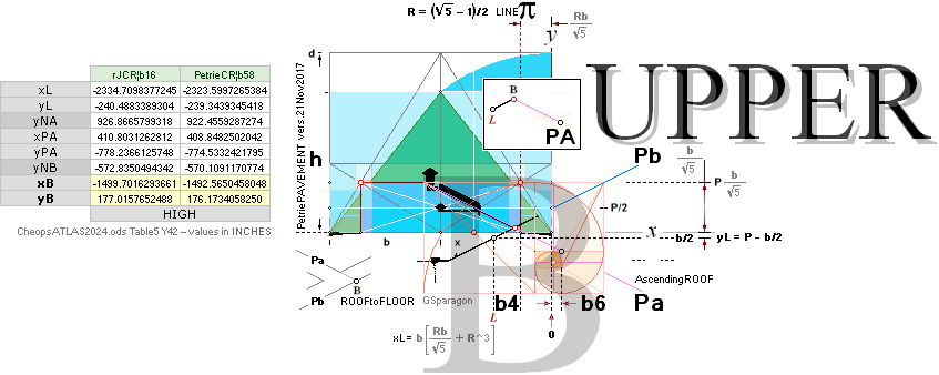
———————————————
BPOINTmain ¦ TABLE OF RESULTS — the original (2020) same values ¦ Agent16 b-value 4555.88’’ — main rJCIRCLE agency ¦ Agent58 b-value 4534.20’’ — 58R√1600
= 4534.196575969’’, = 4534.20’’
CheopsATLAS2024.ods Table5 Y42 —
values in INCHES
Blower: Bupper ¦ Organization
LOWER — intersecting lines:
We use the same PbLINE GS paragon matrix system preferences as
above in the UPPER determination part. The comparing
PaLINE reference is as specified below.
CORIH: BpD ¦
UPPER
— see above
NORMAL GS SQUARE CIRCLE TANGENT DEFINES THE LOWER
LINE PART
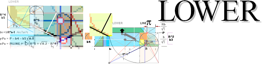
———————————————
bn ¦ Pn ¦ BPOINTmain ¦ TABLE OF RESULTS
LineCROSSxy: DeLIC
¦ BpointCoordinates
TanA=+½
xL = b4 + piLINE
yNA = yL + xLTanA
—————————————
CheopsATLAS2024.ods Tabell5
Y42+
——————————————————————
TanA=–½ ¦ LineCROSSxy
xPA = xPA = –[piLINE + b(b6 + b5√0.2)] =
-1967.2763514308’’
yPA = P – b4 — b5√0.8 = 367.4334862936’’ ¦ PREFIXxSIN: (sin¦cos ArcTan½)² = 0.8 ¦
0.2
yNB = yPA + xPATanB = -616.2046894218’’
B-LOWER line agent point coordinates
—————————————
CheopsATLAS2024.ods Tabell5
Y45+
The GS circle matrix tangent in
GS-square (GSbPn) b5 matches the Petrie
lower Ascending unnel floor — on a previous lowPa parallel GS
defined -ArcTan½
line. Setting up the coordinate complex, now calculating a new Agent16 LowB
point, gives
BpointLOWER
lowxB = (yNB – yNA)/(TanA – TanB)
=
-1543.0712693536’’’’ ¦ 1543.07’
lowyB = yNA + TanA · xB
= 155.3309452550’’ ¦ 155.33’
—————————————
CheopsATLAS2024.ods Tabell5 Y48+
GOLDEN SECTION B POINT SOLUTIONS
ResultingPICTURE:
The Golden Section Agent Plan
— Part 1
xBhigh = -1499.7016293661’’ ¦ 1499.70 ¦ = (yNB
– yNA)/(TanA – TanB)
yBhigh = 177.0157652488’’ ¦ 177.02 ¦ LineCROSSxy
—————————————
CheopsATLAS2024.ods Tabell5 Y48+
ResultBpoint: Blower
¦ BpointCoordinates
¦ xyBhigh
ASCENDING PASSAGE FROM POINT B —
GS-DEFINED FIX GEOMETRICAL QUANTITIES — Jan2020 ¦ Jam2024
SCALE: 2pixel/1’’
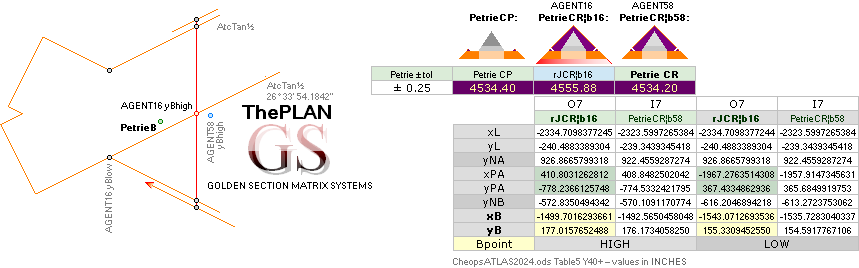
———————————————
PetrieB ¦ CheopsATLAS2024.ods Table5 Y40+ —
values in INCHES ¦ Agent16 ¦ Agent58 — GS GOLDEN SECTION
MATRIX SYSTEM PROVING ASSISTANTS — METHOD
THE7BEGIN ¦ BpointDetermination
¦ ContractedConstructVerified
BpontDetermination ¦ xyBPetrie ¦ GSBsolutions ¦ DeLIC ¦ BupLowOrg ¦ Bupper ¦ BPco ¦ BPAL ¦ Blower ¦ CORIH ¦ LineCROSSxy ¦ xPAref ¦ xBhigh ¦ yBhigh ¦ ResultBpoint ¦
Height18: — SUBTERRANIAN TO
CASE — nFACTOR — Pangle and Hangle
— FormatingBUARMyATH
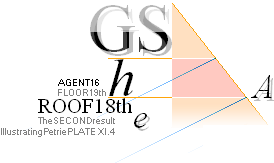
STAGE 1 FormatingBUARMyATH — CASING AND GALLERY
CONNECTIVITY
yATHcalculation —
yATHsymmetry — THE GALLERY CONNECTIVITY : BconnectingPG— THE CASING
CONNECTIVITY: CorridorHeight — The Contracted Construct
STAGE 2: This article: SUBTERRANIAN-CASING PLAN
CONNECTION, THEnFACTOR, DEFINING PETRIE’S MEASURED 18th ROOF/19th FLOOR
PAVEMENT HEIGHT, DEFINING PETRIE’S MEASURED HanglePangle VALUES — branching to
Petrie’s B-point coordinates as calculated, and Petrie’s measured
CorridorHeight
yBlimitCALCULATION — depends on HanglePangle (illustrated)(EXTRECON)
Solution: FIRST RESULT APPLICATION TEST
SOLUTION TO THE HEIGHT OF THE 18th ROOF’S 19th
FLOOR — continuing from SecondResult
THE HEIGHT OF THE 18th ROOF ¦ 19th FLOOR
INTRODUCTION The nFactor — »basement Petrie symmetry»
|
|
Similar to ChEX as explained in METHOD: Projecting the GS (GoldenSection) matrix geometrical body over our PetrieCP given measured Cheops Pyramid, we search/scan for structural congruities. Directly: It seems we have 7+1(F) basic (The7: KGLHBMA) points on a same line, the GS body’s ARCtan½ line. Using the GS body fractal matrix circle-square alignments, we seek aligning reference xy-points to calculate the values for these significant points. Then we take it further from there — testing if the results have any further lead. As we will study: they most safely and definitely had. See the appending separate section in The7BEGIN and the following. We use a simple (DeLIC) line crossing trigonometric connection by which we receive xy-point values where crossing lines need a solution. Pyramid SCALE: Half Pyramid base (bPetrie 4534.40’’) equals 100 pixels. The following text will use and relate the results from The7. All 7 line-points K G L H B M A share one and the same simple elementary Golden Section ARCtan½ line angle 26° 33’ 54.1842’’ = 26.565051177° — IN THE PLAN of the building. — These are — then — never
found in the actual construct by direct measure. We will see how. |
———————————————
ChEX ¦ METHOD ¦ GS ¦ PetrieCP ¦ The7BEGIN — The7¦ DeLIC ¦ bPetrie 4534.40’’ ¦ ArcTan½
DIVULGING THE BASIC PLAN — ».. opening the first
secret door ..»
ROOF18 ¦ MainConstruct
¦
Agent 16 — CheopsATLAS2024.ods Tabell2 B27
xG = 4221.8156658449’’ ¦ 4221.82’’ = xK + 2(b – b/√2)
yG = 1184.0412529906’’ ¦ 1184.04’’ = yF
Agent 58 — CheopsATLAS2024.ods Tabell2 D27
xG = 4201.7254427703’’ ¦ 4201.73’’ ;
same math through shorter
pyramid base, see Agent 58
yG = 1178.4067926577’’ ¦ 1178.41’’ ;
-----------------------------------------------------------
n = (yG¦16 – yG¦58)/2 ; Agent 16¦58 mean average
= (1184.04 — 1178.41)/2 = 5.63/2
= 2.815 ;
yGPetrie = yG¦16 – n = 1184.04 — 2.815 ;
=
1181.23 ; GoldenSection calculated
Petrie y-value
yPETRIE = 1181.10 ± 1 ? as quoted ; difference: 0.13’’
xGPetrie =
xG¦16 + 10R = 4221.82 — 6.18
=
4228.00 ; GoldenSection calculated
Petrie x-value
yPETRIE = 4228.10 ± 2 ? as quoted ; difference: 0.10’’
Petrie G point confirmed (as quoted).
IdealAndConstructAnglel:
nSymmetry:
THEnFACTOR
The xyG points (GpointParams ¦ The7BEGIN) from the two employed GS Pyramid agents Agent 16¦58 form a close quantitative yn (2.81’’) symmetry around the (not very accurately known, very nasty place) Petrie measured G point in the bottommost subterranean descending passage region.
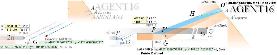
GOLDEN SECTION VERIFIED Petrie Subterranean G-point xy coordinates:
PetrieCH7.36 ¦ — PetrieSOURCE
:
”
The absolute position, then, of the middle of the S. end of the entrance
passage floor will be, in level,
668.2 – (4140 X sin. 26° 31' 23") – .8
difference of floor offsets = – 1181 ±
1 ?; in distance from N. base of pyramid
524.1 + 3704.3 = 4228 ± 2? or 306 N. from mid-plane; and in distance E. from the
mid–plane
287.0
– [ sin. (3' 55" – 3' 44") x 3704 ] – .4 difference of offsets =
286.4 ± 1.0.”;
The n factor — has decicive
influence
———————————————
Taking advantage of the offered opportunity, the Petrie G point y-symmetry gallantly defines an n factor from the mean difference between the two Pyramid agents’ vertical coordinates (see Pyramid Coordinate System). With the Petrie specified tolerances, it is suggested that the Petrie yG position lies (exactly) between the two Agent’s different yG.
The general testing npin
factor
The GS ARCtan½ nHYPO (hypotenuse) value √ n2 + (n/2)2 = 3.1497590802’’ might be a second hand choice before the close pi-constant π = 3.1415926 if no hazard.
nHYPO = √ n2 + (n/2)2 = 3.1497590802’’ ¦ 3.15
possible constructor’s stressed alternative:
nHYPO = π = 3.1415926536’’ ¦ 3.14 — we can test/compare our results and see if it matters [ ± 0.01’’ ]
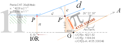
(GregionFactors) In this presentation a selector has been employed in the calc program. It allows a test on all the listed equative consequtive results, comparing between an original nHYPO and a regular π. We suspect, namely, that the constructors (also) would have preferred such a choice. Further reports will tell if, and how, that test works out. The common term factor here is named the npin with a (CalcCell) selected 1 for π (n=2.8099258924’’=pin) and 0 for nHYPO (n=2.8172301665’’=n). We will in this presentation give all results in the selector mode 1, unless otherwise stated.
ConfirmingPetrie19th:
ThirdResult: rJCIRCLEverified:
A first strong n-factor
vindicated application
CONFIRMING THE PETRIE-MEASURE 18thROOF 19thFLOOR
HEIGHT OVER PETRIE PAVEMENT: 668.15’’ ¦ Petrie 668.20’’ ± 0.10’’
See GpointParams
yA = 665.3382779782 = –xH/(cotanA° + cotanP°) ; tanP° = 1/√R = yA/xA
= xH/(2
+ √R) ; The general R
connection gives a simplified triangle- equation
y18ROOFcon: ConfirmingPetrie19th
RESULT:
Explain y18thROOF 668.1482038706’’ ¦ 668.15 19th course floor over pavement
” Having, then,
fixed the original position of the doorway of the Pyramid, we may state that it
was at
668.2 ± .1 above
the pavement of the Pyramid;”,
Pushing the (nSYMMETRY) basic G.A line ARCtan½ triangle vertically up by the n-factor value (npin = 2.8099258924’’ ¦ 2.81’’) gives the result:
665.3382779782 + 2.8099258924 = 668.1482038706 ¦
668.15
” Having, then,
fixed the original position of the doorway of the Pyramid, we may state that it
was at
668.2 ± .1
above the pavement of the Pyramid;”,
Difference: 0.05’’
PetrieROOF18 verified.
Petrie yA ROOF 18 height confirmed as quoted.
See further on Petrie’s xA value in PETRIExA.
EXTRECON: HanglePangle: — y18ROOFcon
EXTRACTING RECURRING CONSTANTS
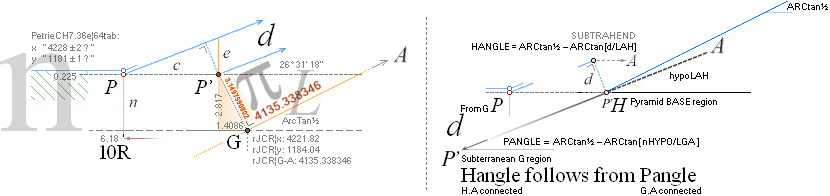
Petrie P and H angles confirmed (as quoted):
We use an angular Minuend – Subtrahend method to
calculate possible Petrie angle candidates from the appearing Agent16¦58
factors in the Golden Section Matrix system :
AngularCandidatePangle = ARCtan½ – ARCtan(nHYPO¦π/L) = 26° 31’ 17.486086’’ ¦ Petrie’s ” 26° 31’ 23’’
± 5’’ ? ” diff:
0° 00’ 05.513914’’ »OK with ?»
AngularCandidateHangle = ARCtan½ – ARCtan(d/LAH) = 26° 28’ 58.546758’’ ¦ Petrie’s ” 26°
29’ ± 1’ ” ................... diff: 0° 00’ 01.453242’’ OK
THERE IS A COMPLEMENTARY
PANGLE VALUE THAT IS PRACTICALLY INDEPENDENT OF THE npin
FACTOR ALTERNATIVES — through the yConB-factor:
AngularCandidateOangle = ARCtan½ – ARCtan(yConB/L) = 26° 31’ 23.926248’’ ¦ Petrie’s ” 26° 31’
23’’ ± 5’’ ? ” diff:
0° 00’ 00.926248’’ OK:
BUT WE CANNOT USE THIS
FOR A PANGLE REPLACEMENT BECAUSE THE Oangle yConB CALCULATION DEPENDS ON A
PANGLE REFERENCE.
” The absolute position, then, of the middle of the S.
end of the entrance passage floor will be, in level,
668.2 – (4140 X sin. 26°
31' 23") – .8 difference of floor offsets = – 1181 ± 1 ?; in distance from N. base of pyramid
524.1 + 3704.3 = 4228 ± 2? or 306 N. from mid-plane; and in distance E. from the
mid–plane 287.0 – [ sin. (3' 55" – 3' 44") x 3704 ]
–
.4 difference of offsets = 286.4 ± 1.0.”;
WE USE THE CONVENTIONAL LINE EQUATION (y1–y2)/(x1–x2) =TanA to retrieve Petrie’s results with Petrie’s inputs —
the Ny value: where A crosses the vertical Pyramid North corner y=0-axis.
![]()
CheopsATLAS2024.ods Tabell2 P57+
— We see
that Petrie uses a HypoLength 4140 instead of the — from Petries specified xy-values
— resulting 4139.90: The difference shows up in the Pangle result as 21° 31’
56.090736’’: not quite the Petrie stated angle. Testing the Petrie
suggested tolerances will also alter the Petrie claimed HypoL-value —
presenting other values than the Petrie stated. We have no mandate on such
speculations.
— We can
only state the fact, that with Petrie’s given data as the above specified
inputs, the Petrie specified angle 21° 31’ 23’’ does not show up. The
Petrie given question mark is our best guide here.
The n-factor has a subterranean G region set of triangular parameters defining further useful constants, as depicted. From these are defined two central angular constants Hangle and Pangle also mentioned and specified in Petrie’s work with associated tolerances. Further below.
The trigonometric connections are deduced as the above illustrated draft. The connections are also specified in the CheopsATLAS2024.ods OpenOffice Calc program’s tabled details as collected in the following sets.
CALCULABLE GOLDEN SECTION
MATRIX DETAILS
From the above results:
—————————————
THE yBlimitCALCULATION (EPA: uses xyHB, HanglePangle, G-region details in this article)
solves for Petrie values in
xyPetrieBpoint
¦ Corridor height
—————————————
Continue:
ExtraCON: CDetailsH18
¦ EXTRECON
EXTRACTING THE RECURRING CONSTANTS
nHYPO = √ n2 + (n/2)2 = 3.1497590802’’ ; difference to pi = 0.00817’’ ¦ should be OK to use, inside margins
L = | xG – xA | · √
1.25 ; xG — xA = d ; dHYPO = √ d² +
[d/2]² = d √ 1 + 1/4 = d √1.25
= 4135.3383474429’’ ;
PANGLE° = ARCtan½ – ARCtan(nHYPO¦π ÷ L)
= 26.5215239127°
= 26° 31’ 17.486086’’ ; slightly less than ARCtan½
Petrie = ”
26° 31’ 23’’ ± 5’’ ? ” ;
PetrieCH7.36e
as quoted
Difference = 5.514’’ ; outside the tolerance WITHOUT
Petrie’s QUESTION MARK
PANGLEnHypo = 26° 31’ 17.079’’ ; this is the only quantity in the complex with an unresolved precision
nHypoDifference = 5.921’’ ; outside the tolerance WITHOUT
Petrie’s QUESTION MARK
——————————————————————————————————————————————————
Petrie verified Pangle: EighthResult: PANGLE ;
WITH PETRIE’S QUESTION MARK — see abbreviation example
HanglePangle illustrated
——————————————————————————————————————————————————
= 4.7753769413’’ ;
e = cTanPANGLE
= 2.3831554097’’ ;
d = eSinPANGLE ; PREFIXxSIN ¦ Construction plan level G
= 2.1323680500’’
LAH = 2yA√1.25 ; 2yA = xA
= 1487.7416175918’’ ;
HANGLE° = ARCtan½ – ARCtan(d/LAH)
= 26.4829296551°
=
26° 28’ 58.547’’ ; slightly less than PANGLE
Petrie = 26°
29’ ± 1’ ;
PetrieCH7.36e
as quoted
” (4) entrance passage angle at mouth 26° 29’ ± 1’ ”
Difference = 1.453’’ ; ARCseconds — well within Petrie’s
tolerance ± 1’
= 26° 28’ 58.547’’ ; using π for nHYPOO
Difference = 1.453’’ ; ARCseconds — well within Petrie’s tolerance
± 1’
Petrie verified Hangle: NinthResult: HANGLE
8HanglePangle illustrated
————————————————————————————————
CheopsATLA2024.ods Tabell1 A24+
Gconstruction plan:
SCALE: 20pixel/1’’ — Confirming19th
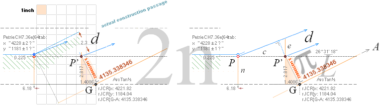
n-Factor orientation, Cheops Pyramid subterranean
details. After Flinders Petrie’s measures 1881-1883. See PetrieSOURCE.
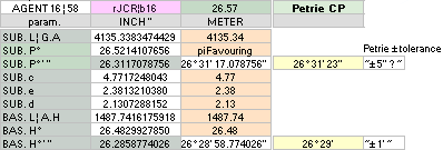
CheopsATLAS2024.ods Tabell2 A44+
Results: FirstResult ¦
SecondResult
¦ ThirdResult
¦
Apart from Petrie’s quoted question mark tolerance
(”±5’’ ? ”) — in the rJCIRCLE Golden Section complex calculated
corresponding Pangle: all present values show (good)
Petrie tolerance acknowledging.
The remaining Petrie x coordinate
FINISHING ON FLOOR 19th
Continuing on Petrie’s 19th
FLOOR xy-coordination
PETRIExA — The redundant
Further:
EPA — determining the exact GS
corridor height
Height18 ¦ SolutionA ¦ DIVA ¦ THEnFACTOR ¦ IdealAndConstructAngle
¦ nSymmetry ¦ PetrieROOF18
¦ THEn ¦ Npin ¦ ConfirmingPetrie19th
¦ ThirdResult ¦ rJCIRCLEverified
¦ y18ROOFcon ¦ EXTRECON ¦ HanglePangle
¦ CDetailsH18 ¦ ExtraCON ¦ nHYPO ¦ Rot125 ¦ PANGLE ¦ PetriePangle
¦ EighthResult ¦ dREF ¦ HANGLE ¦ PetrieHangle
¦ NinthResult ¦ ConPlanG ¦ GregionFactors ¦ Results123
¦
PETRIExA: Results123
FROM: EquationSecondITERA
— Course19th
— FINISHIN ON FLOOR 19tn
IT DEPENDS ON THE RELATIVE ESTIMATION OF THE
ORIGINAL CASING SLOPE, WHICH HOWEVER IS NO LONGER EXISTENT ON THE BUILDING
THE REDUNDANT PETRIE 18th ROOF xVALUE
See Petrie Quotes in PetriPyramidAngle
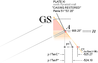
AS STATED (Course19thITERATED ¦ Cource19thCHECKED):
Petrie EntranceCorridor-19thCourse MIRROR Height Golden Section Connection confirmed (Revisiting the angle):
CheopsATLAS2024.ods Tabell2 Q19+
Taking the Petrie (he) specified values on the Petrie specified descending entrance passage sloping angle 26° 29’ on the given TrigonometryEequation
h = e cosA/cos(A+B)
¦ Deduction ¦ PREFIXxSIN
only certifies the Golden Section Cheops Rectangle bd=h² solution. As stated (Stressed5153):
That is what a Petrie inevitably land surveying
trigonometric technique would have had to observe — Petrie’s corresponding
Plate XI as ”CASING RESTORED”
—
![]()
in his corresponding and concluding statement (over
the above)
51° 53’ 20’’ ± 1’ (corresponding to Petries
specification on the North pyramid wall PetrieCH6.s24):
The simple corresponding PetriePlateXI.4 illustration — North side Pyramid wall:
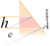
Petrie as quoted:
— ” The
answer has been already given in the list of determinations of the casing
angle. It requires an angle of slope of
51° 53’ 20’’ ± 1’ ”.
— With the Petrie stated values h = 37.94, e = 47.26 and B = 21° 29’ the trigonometric answer is as above (C19thITERATED):
51° 49’ 34.66’’ — compare Golden Section Cheops Rectangle pyramid angle ARCtan 1/√R:
51° 49’ 38.25’’ — difference 3.59’’
and not at all the Petrie claimed/stated (PetrieCH6.s24 10 weighted N face)
51° 53’ 20’’ which very well could be the
true actual stone masonry staircase sloping angle, North Pyramid wall.
The result, it says, is perfectly clear on the input parametric fact that the TrigonometryEequation as such — what we know, apparently — was never employed by Petrie. His reference seems only to pertain to the evaluated list of measured angles and their weights of importance in his section PetrieCH6.s24. Only one of these, the second, have a close 51° 49’ (± 1’) but with a low weight value of only 2 (1-10).
The idea of »an exact actual
angle» on the already highly removed outer parts of the Cheops Pyramid (also
noted by Petrie) has lost all original features connected
to any idea at all of a casing — except on the few left casing stones at the
(north) Pyramid base — and except as
indicated by the 19th floor trigonometric equation with known distances (he)
and a sloping entrance passage angle (B):
So, in conclusion, we have a
certain mandate to state on the above related causes (Petrie never used the TrigEquationAB):
— Casing Angle from Petries certainly tight measured heB : 51° 49’ 34.66’’.
See Explain19th.
”
These levels, though important for the heights of the particular courses,
have
scarcely any bearing on the question of the
original peak of the casing of the pyramid,
because
we have no certain knowledge of the thickness
of the casing on the upper parts.”.
The TrigonometryEequation as such was never employed by Petrie.
— It gives the answer. But was apparently never observed.
CheopsATLAS2024.ods Tabell2 Q19+
So: The Petrie stated xy-values (524.1; 668.20) on the horizontal part of the coordinate specification measure of the Casing Entrance Floor point A,
PetrieCH7.36 ¦ PetrieROOF18 — PetrieSOURCE :
”
The absolute position, then, of the middle of the S. end of the entrance
passage floor will be, in level,
668.2 – (4140 X sin. 26° 31' 23") – .8
difference of floor offsets = – 1181 ±
1 ?; in distance from N. base of pyramid
524.1 + 3704.3 = 4228 ± 2? or 306 N. from mid-plane; and in distance E. from the
mid–plane
287.0
– [ sin. (3' 55" – 3' 44") x 3704 ] – .4 difference of offsets =
286.4 ± 1.0.”;
PETRIExARelated: PETRIExA
has »a partly corrupted» x-value (the 524.10 part).
— The Petrie calculated 524.10’’ is exactly what we get from taking the steeper Petrie Casing angle P° = 51° 53’ 20’’ on our more exact height 668.148’’ of the 19th floor level (18th roof)
x = y/tanP° = 668.148’’/1.274838 = 524.1042170704’’ ¦ 524.10’’
If Petrie — as we do — had used the above related result from the TrigonometryEequation P°’ = 51° 49’ 34.66’’ and the more precise 668.148’’ for yA, the found x value would be
x = y/tanP°’ = 668.148’’/1.274838 =
526.2283998884’’ ¦ 526.23’’
And our ideal Cheops Rectangle Pyramid has the corresponding
x = y/tanC° = 668.148’’/1.272020 = 525.2654707459’’ ¦ 525.27’’
INcon: PETRIExARelated
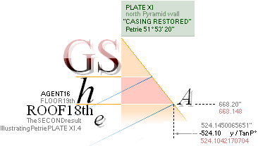
So in conclusion:
BECAUSE — unless some disclaiming power exists — Petrie never used the TrigonometryEequation, but apparently only relied on measuring data on a sadly sored edifice (”Chap. 6. Outside of Great Pyramid • Sec 24. Angle of the Pyramid”: PetrieCH6.s24 although he would not have had to, in this region), Petrie came to favor »a featuring Casing angle» 51° 53’ 20’’ which — trigonometrically calculated — hides the above related result 51° 49’ 34.67’’ a clear Golden Section reminder from the equation Petri never employed.
— These details however, make nothing to the whole general picture — except on the divulging fact, that IF Petrie had employed what he actually didn’t, the Golden Section Matrix building would have been unveilded already the year 1883.
What we know. No further complexities of the kind exists inside the Petrie group work on measuring The Great Pyramid at Giza in Egypt (1880¦1881-1882¦1883).
Editor2024II1
Confirmed Petrie
points — in short summary:
PetrieGpointConfirmed — subterranian
region¦ y18ROOFcon — yA CASING¦ EXTRECON — connecting
P and H angles ¦ PETRIExA —
Corridor19thCourseMIRROR GS confirmed
Following sections:
CALCULATING THE PETRIE VALUES ¦ GpointPARAMS
¦ FIRSTyxA ¦ BpointDetermination
¦ BPAL — ascending UpperLower ¦ CORIH — corridor dimensions ¦
EPA — entrance passage angle:
DETERMINING/testing THE »exact» CORRIDOR HEIGHT ¦ TUNNELcross ¦ PetrieBpointCalculated
¦ ContractedConstruct — from plan to construct¦
SIOillustrated ¦ M74GS ¦ TCC ¦ PetriePG ¦ dSTEP ¦ yKING ¦ TUNGAL — collective illustration ¦
PCS — PYRAMID COORDINATE SYSTEM ¦ NotesOriginal2017
¦ GoldenSectionMatrixSYSTEM
¦ VOOD — verification
method¦
Links from the 2020 version (and the Swedish 2017 original CheopsRektangel) in CheopsATLAS are frequently referred to (the basic work).
— We get the picture of how the subject did develop — including eventual errors (on a less developed vocabulary ..).
Height18 ¦ y18ROOFconsequences
PETRIExA ¦ ExplainA ¦ RevisitingTheAngle
¦ PETRIExARelated
¦ INcon ¦ ConfirmedPetriePoints
— short summary¦
FormatingBUARMyATH:
xPetrieB
Stage1
COMPLETING B POINT REGION DETERMINATION — its Casing and Gallery Connectivity
Using the previously Agent16¦58 deduced xyB
FORMATING BUARM AND yATH
yASCENDING TUNNEL HEIGHT — B-POINT UPPER ASCENDING
ROOF MEAN AVERAGE
----------------------
BUARM = abs(xB¦A16 – xB¦A58)/2
; B-point Upper Ascending ROOF
Mean average, or
= 3.5682917806’’ ¦ 3.57 ; »upper ascending ROOF
averaged mean difference»
yATH = 2(yBhigh – yBlow)
; same Bhigh intersecting
vertical on the ideal ARCtan½ sloping corridors
= 43.3696399875’’ ¦ 43.37 ; marker for decending and ascending basic passage
height determination
yBarm = yATH + BUARM ; »BUARMyATH»
= 46.9379317681’’ ¦ 46.94
= 133.6461252613’’ ¦ 133.65
= 130.0778334807’’ ¦ 130.08
bOFFSET = b¦A16 – b¦A58 ; the two Pyramid agents’ half
pyramid base difference
= 4555.876483882’’
– 4534.196575969’’
= 21.6799079131’’ ¦ 21.68 ; » the final sealing ». — »We
are just warming up».
yATHsymmetry: TUNNELcross: SCALE: 2pixel/1’’ — EPA
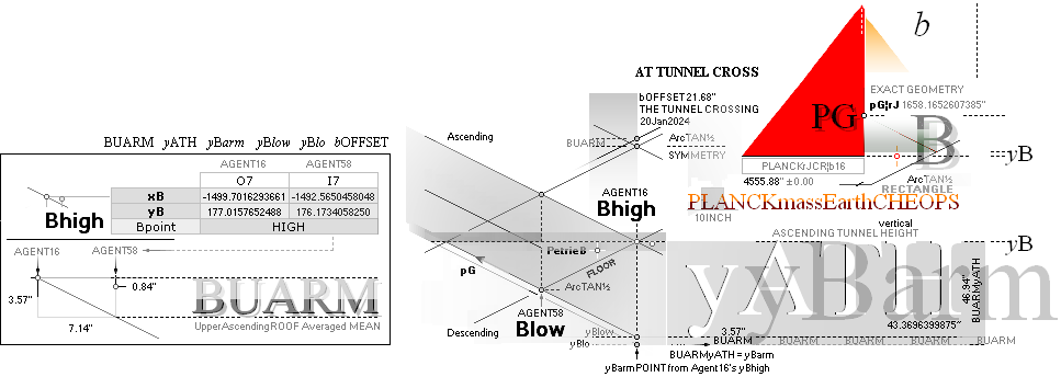
Using the previously Agent16¦58 deduced BUARMyATH
It is advanced. Consequential
Mathematics (COMA
¦ HumanRightsRecognition).
THE GALLERY CONNECTIVITY:
Corridor vertical height (c=Vh)
— summing parts
THE CASING CONNECTIVITY — needs EPA yBlimitCalc — SIO yConB: yHangleBend + yPangleHend
CorridorHeight ¦ yBlimitCALCULATION
:
»Mirror reflectivity» trigonometry — 19th Course from Corridor vertical height (c=Vh)
THE CASING CONNECTIVITY — same as SecondResult —
The7BEGIN ¦ BpointDetermination
¦ xyBPetrie
FormatingBUARM-yATH ¦ yATHcalc ¦ BUARM ¦ yATH ¦ yBarm ¦ yBlow ¦ yBlo ¦ bOFFSET ¦ yATHsymmetry
¦ TUNNELcross
¦
yPG: BconnectingPG: yATHsymmetry
Using the previously Agent16¦58 deduced BUARMyATH
Defining
THE TUNNEL CROSSING (B) CONNECTION WITH THE GALLERY
RAMP TOP (yPG) — PYRAMID CENTER
— For each new factor derived, it
contributes or directly points to a next veryfying step or Petrie measured
value in the building.
Petrie’s value [ ± 0.60’’ ] 1658.20’’
Explain yPG 1658.1652607385’’ Gallery RampSlope TopStop over pavement
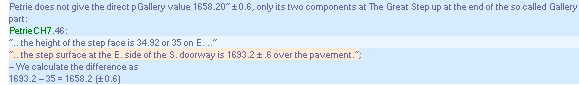
The yBarm point from Agent16’s yBhigh marks a further step forward enhacement in the mathematical treatise of the GS Golden Section Matrix System in the Petrie measured Cheops Pyramid:
SCALE: 2pixel/1’’
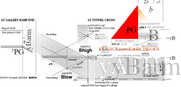
———————————————
It works through the bOFFSET (21.68’’) between the two Agents 16¦58 so:
b(Agent58¦4534.20’’ inside Petries tolerance)
yPG = [4534.20 + (4555.88 – 4534.20 = 21.68) – xB(Agent16, = -1499.7016293661’’ ¦ 1499.70)]/2
+ yBlow(=133.6461252613’’ ¦ 133.65) – BUARM(=3.5682917806’’ ¦ 3.57)
=
1658.1652607385’’ ¦ 1658.17
= (4534.2 + (4555.88 - 4534.2) - 1499.7)/2 + 133.65 - 3.57 = 1658.17
=
(4534.1965759686
+ (4555.8764838817 - 4534.1965759686) - 1499.7016293661)/2 + 133.6461252613 -
3.5682917806 = 1658.1652607385
Compressed Petrie verified Gallery ramp end:
METHOD STRUCTURE
absolute values
yPG = [b(Agent58) + bOFFSET – xB]/2 + (yB – yATH) – BUARM
=
(4534.2 + (4555.88 - 4534.2) - 1499.7)/2 + (177.02 - 43.37) - 3.57
= 1658.17
= [b(Agent58) + bOFFSET – xB]/2 + (yBlow) – BUARM
= [b(Agent16) – xB]/2 + (yBlow) – BUARM
= [b(Agent16) + xB]/2 – xB + (yB – yATH) – BUARM
=
(4555.88 + 1499.7)/2 - 1499.7
+ (177.02 - 43.37) - 3.57 = 1658.17
= [b(Agent16) + xB]/2 + yB – yBarm
= 1658.1652607385’’ ¦ 1658.17
=
-(-4555.88 - -1499.7)/2 + 177.02 - 46.94 = 1658.17
= [b(Agent16) + xB]/2 + yBlow – yBarm
= (4534.2 + (4555.88 - 4534.2) - 1499.7)/2 + 133.65 - 3.57 = 1658.17
Explain yPG 1658.1652607385’’ ¦ 1658.17 Petrie verified: diff 0.03
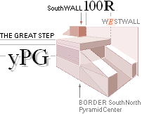
Petrie Pyramid Center Gallery RampTop verified.
THE CHEOPS PYRAMID CENTER
AT THE PYRAMID VERTICAL CENTER — ideally Petrie’s 4534.40’’± 0.25’’ from Pyramid North base
——————————————————
xPG = Pyramid Center ¦ ideal gravity vertical
= bAgent58
=
4534.20’’ — inside
Petrie’s tolerance. Difference rounded: 0.20’’ ¦ 0.00508 M = 5.08 mM
bPetrie = 4534.40’’ ± 0.25
Petrie Pyramid Center verified.
PetrieCH7.46: Cheops Pyramid Center
” At the upper end of the gallery, we have
already stated the S. wall to be 61.7 ± .8
of the Pyramid centre; and hence the face of the great step at the head of the
gallery (which descends behind both floor and ramps) is (61.7 – 61.3) = .4 ± .8 S. of the Pyramid centre. It may,
therefore, be taken as intended that the face of this step, and the transition
from sloping to horizontal surfaces, signalizes
the transit from the Northern to the Southern half of the Pyramid. This
same midplane of the Pyramid being also
signalized by the midplane of the Queen's Chamber, which is measured as .3 ± .8 N. of the Pyramid centre.
[p.
75] The ramps along the sides, where they join this great step, are very
irregular. Their top surfaces slope away downwards toward the side walls; thus the
E. ramp top varies from 13.20 to 12.18 below the step from E. to W., and the W.
ramp top from 12.82 to 12.2 (?) from W. to E. At present, moreover, the ends of
the ramps are parted away from the face of the step by .30 on E. and .44 on W.,
an amount which has been duly subtracted from my length measures of the
gallery. Beside this, the top of the step itself, though, straight, is far from
level, the W. side being about 1.0 higher than the E. side. And the sloping
floor seems to be also out of level by an equal amount in the opposite
direction; since on the half width of the step (i.e., between the ramps) the
height of the step face is 34.92 or 35.0 on E.,
and 35.80 or 35.85 on W. The length of the step from N. to S. is on E. side
61.0, and on W. 61.5. All these measurements are very carefully taken with
elimination of wear, fractures, and shifting of the stones at the joints.
Hence, at the line along which I measured, 6 inches from the edge of the ramp,
the step will be 61.1 long; and this at the angle 26º 12' 50" (by which
the end of the gallery was calculated from the plug-blocks) will be 30.08
vertically, for the virtual9 above the
actual floor end. Then the top of the step will (by above measures) be here 34.88
above actual floor end, and the step dips about .64 to the S. wall at this
part; so the top of the step at the S. wall is 34.88 – .64 – 30.08 = 4.16 (say
± .2) above the virtual floor end at the line of taping. And as the virtual
floor end is at 1689.0 ± .5, the step surface
at the E. side of the S. doorway is 1693.2 ± .6 over the pavement.”.
Note:
Petrie’s specification type ”.4 ±
.8” explains the tolerance greater (twice) than the measure. Our (PCS)
ideal GS Golden Section Cheops Rectangle Cheops Pyramid has the (exact) center
specified by Petrie’s half Pyramid base as quoted (4534.40’’ ± 0.25’’).
So, there should be little doubt that the Petrie described vertical step face
at the gallery ramp end marks or defines a vertical East-West center wall of
the Pyramid.
yPG ¦ BconnectingPG ¦ PetriePG ¦ yPGcalc ¦ PyramidCenter
Based on comparing the Petrie
Cheops Pyramid measures
DETERMINING/testing THE »exact» CORRIDOR HEIGHT
BASIC GOLDEN SECTION GEOMETRICAL MATHEMATICS only
h = ([bPETRIE =
4534.40’’]/100)(2 · 3 · 18 / 100)² · √0.8 ¦ PREFIXxSIN: (sin¦cos ArcTan½)² = 0.8 ¦
0.2. See FirstRESULT.
h = 47.3055757984’’. It is
calculated from the (LCD Screen) pixel height of Petrie’s Cheops data Ascending
passage tunnel scaled version (bPetrie = 100p) here in UH.
PetrieCH6.32.r56: ”
entrance passage angle at mouth 26°29’ ± 1’, entrance passage height 47.26”.
No specified tolerance in that
quote. Text above (r32) specifies ”mean doorway height .. 37.67 ± .17”;
Adopting 47.26’’ ± 0.17’’,
our (numeric) 47.3056 is OK (+0.0456).
” (4) entrance passage angle
at mouth 26° 29’ ± 1’ ” ; Petrie’s 668.20’’ ¦ xyINpos ¦ x = 524.1’’
— PetrieCH6.32e: 26° 29’
± 1’ ;
Hangle ¦ HangleINTRO, CheopsATLAS.htm
26.49629943° = the actual
Petrie measured angle
26.56505118° = aTan½ —
the ideal GS paragon angle.
PetrieINentrance
Descending passage angles,
listing
PetrieCH7.38, Col3 — reporting some of the difficulties in
determining the details in the Petrie B-point
R-fractals ¦ GS-series ¦ LineINTERSECTblock ¦ GSParagonARITHMETICS ¦ The7
yBlimitCALC: EPA
yBlimit CALCULATION
FINALIZING ON PETRIE B POINT DETERMINATION
----------------------
----------------------
yBlimit
: TunnelCROSS — absolute Construct Limit
HBA floor
yHangleBend = abs(xH – xB)tanHANGLE
– yB ; xyB HIGH Agent16
= -0.6338339337’’ ;
yPangleHend = abs(xG – 10R – xH)tanPANGLE + yG + n
= 3.6463097198’’ ;
yConB = yHangleBend
+ yPangleHend
; absolute HBA construct limit floor base
= 3.0124757861’’ ;
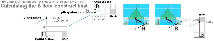
d = 2.1323680500’’ ; basement G section details ¦
Construction
plan level G
D = [d/cos(PANGLE° + C°)] cos(C°) ; C° = ARCtan(1/√R)
= 1.7116318595’’ ;
SIO = n – D ; secure inspection offset — SIO
illustrated
= 1.0982940329’’ ; also yConBoffset
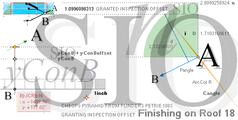
=
4.1107698190’’ ; PI-valueAlternative dependent ¦ 4.1112567233
18 = see MiUNIT ; as used — when it is offered
rJ/100R√16000
= 0.025400718 an automatic 0.0254 M unit if so rounded on the
Planck Dmax mJ constant
√16000
= 5 · 2 · 2 · 2 · √2 · √5 = 5 · 8 · √2 · √5 = ([58
= 5 · 8 + 18] – 18) · √2 ·
√5 = 40√10 = 5 · 8 · √10.
58R√16000.0
= 4534.196576 ; = (rJ’CR¦b16=198.5665M) · 58/100 = (100R√16000)k0 — see The16Factor
— Agent58
See also The NeutronSquare atomic mass defect electron scale —18 — and petries 18th floor/19th roof — the Pyramid Entrance
See also y18ROOFconsequences
PetrieBpointCalculated: FourthResult:
xyPetrieB
yPETRIE =
172.9090491109’’ ¦ 172.91 ; Petrie:
172.90’’ ± 0.20 ¦ PetrieB
¦ PetrieCH7.64tab
=
177.0157652488 – 4.1107698190’’ ;
Petrie verified tunnel cross measured B-point y coordinate
xPETRIE = -1517.7016293661’’ ¦ 1517.70 ; Petrie: 1517.80’’ ± 0.30 ¦ PetrieB
=
-1499.7016293661’’ – 18’’ ;
Petrie verified tunnel cross measured B-point x
coordinate
Petrie verified. PETRIE’S
MEASURES CAN BE CALCULATED FROM THE rJCIRCLE
Golden Section Cheops Rectangle complex.
xPetrieB: ResulrBpoint
— SCALE: 2pixel/1’’
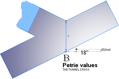
x y
PETRIE 1517.80’’
± 0.30’’ 172.90’’ ± 0.20
GSsolu 1517.70’’ ± 0.00’’ 172.91’’ ± 0.00 approved.
Petrie B-point identified and defined.
CorridorHeight: FifthResult:
ResultBpoint
¦ yATHcalculations
cPetrie EXACT CORRIDOR vertical HEIGHT
Summing — compare FirstEX — Ch, corridor height numerically by Scale: 47.3055758’’
Vh = c = yATH + yBlimit + BUARM + (bOFFSET – 18)/2
= 52.8886555437’’ ¦ 52.88 , × √0.8 =
Ch = 47.3050516137’’ ¦ 47.31 ;
PetrieCH6.32.r56: ” entrance
passage angle at mouth 26°29’ ± 1’, entrance passage height 47.26”.
—————————————————————————————————————
Petrie verified — second method — descending
passage tunnel vertical height, FirstRESULT [
recursively ] certified
—————————————————————————————————————
Transposing the cPlan to the
Construct:
cLENGTH Vh in yPetrieB — as yc = c + yPetrieB — by (DeLIC) k = ARCtan½
defines intersection
NyBP = yc – kxPetrieB
= 984.6444656565’’ ¦ 984.64
The corresponding (Agent16¦58 GS plan) cTop on Agent16’s yBhigh has the vertical
yATH + BUARM = yBarm status. It has a corresponding lower Ny status of
NyBA = (yBhigh + yBarm) – kxBhigh (still same ARCtan½ PLAN draft reference)
= 973.8045116999’’ ¦ 973.80
TCC: TenthResult: TranspositionPLANtoConstruct: FifthResult
Explaining THE CONTRACTED CONSTRUCT — SCALE: 2pixel/1’’
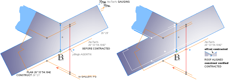
The gauging ARCtan½ x-difference (2yDIFF) defines a CONTRACTED CONSTRUCT — from plan to actual (PETRIEmeasured) building:
NyBA – NyBP = 2(973.80 – 984.64)
= -21.68 ¦ 21.6799079131’’
= bOFFSET
= bAGENT58 – bAGENT16
= 4534.1965759686’’ – 4555.8764838817
= -21.6799079131’’ ¦ -21.68
The alignment settles and defines the xyPetrieB construction point on the cLENGTH top over the xyPetrieB measured tunnel crossing point — from where any appropriate different angular extension may be related. different from the plan’s gauging ARCtan½.
![]()
Contracted construct found and verified.
The Golden Section Matrix System’s cLENGTH determination has — thereby — pinpointed a solid Cheops Pyramid construction point (PetrieB), referring a crossover transfer between decending and ascending corridors. And that is the actual offset push between the two Pyramid agents 16¦58.
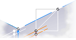
Relating the bOFFSET x-positive (Nortwards) from the yBhigh position, then again same value y-positive upwards, same bOFFSET value, renders the same Ny ARCtan½ gauging alignment, but now higher up with the ARCtan½ gauging plan as »most centered synchronized» with our known Petrie measured tunnel cross view:
ContractedConstruct:
ContractedConstructVerified:
TranspositionPLANtoConstruct — SCALE: 2pixel/1’’
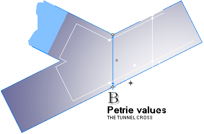
———————————————
PetrieBpointCalculated ¦ Petrie’s Gallery Ramp slope angle 26° 16’ 40’’ — »the B-region angle generator»
Contracted construct — the plan — verified.
— Without our Agent16 alias rJCIRCLE deduced preferences, this described plan and its Petrie defined quantities (within Petrieäs specified tolerances) would have no meaning. It seems settled, that it is only the rJCIRCLE complex that can define the Petrie measured quantities — unless any other explanation will be revealed. Very advanced stuff.
See further below in
ResultTUNNELcross: SeventhResult: Example:
A CONTRACTED CONSTRUCT
From determined PetrieB
and GS-B
THE Petrie CORRIDOR CROSS GOLDEN SECTION PROVABLE CONTRACTED CONSTRUCT
PetrieBpointCalculated — The Petrie B point found
as calculated ¦
CHEOPS PYRAMID COMPLEX OFFSET CONTRACTED CONSTRUCT
— verified
PLACING the EARTHrJCIRCLE Pyramid Agent16 @PetrieBASE as aligned with the physical pyramid’s (the tourist versions ideal Cheops Rectangle bd=h², PetrieCR) North side (bOFFSET), and aligned with Petries basement (PetrieBASE y=0; height offset), sharing the same metrics, the physical pyramid (tourist version in the end) will reflect the offsetted GS Plan Pyramid’s calculated reference points.
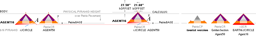
———————————————
Using the GS matrix system’s paragonic gauge as a precise mathematical/geometrical transfer templet, the GS system uses this double offset situation between the two Pyramid agents for defining the xyBhigh/low with The7BEGIN basic ARCtan½ K G L H B M A line points. The Resulting Bpoints define the GS geometric plan in the tunnel cross region. Integrated in its solution is also the connection (B.PG) between the tunnel cross and the Gallery ramp top, defining Petrie’s PetriePG y-coordinate (1658.20’’) at the Pyramid’s center (x=bPETRIE¦ Agent58: Petrie’s half Pyramid base tolerance ± 0.25’’).
That proves in explicit — the Petrie measured verified values — the GS PLAN of the building. And HOW it works from draft to construct — including the (many) several specific angular calculations needed to synchronize the whole. See from Petrie’s here coined HanglePangle.
Course19thHeight: SixthResult: Course19th
37.9653854890’’ ¦ 37.97
hPetrie EXACT 19th Course HEIGHT
Taking the Fifth result’s parallel corridor height Ch
= 47.3050516137’’ through the same equation as in the previous SecondResult
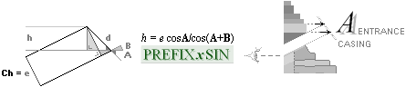
we get the height of the 19th stone masonry course
as
h19th ¦ 2 = 37.9653854890’’ ¦ 37.97
= (e=Ch=47.3050516137’’)1cos(C°=ARCtan 1/√R)/cos(C°+ ARCtan ½)
compared to the previous
h19th ¦ 1 = 37.9658061814’’ ¦ 37.97 ; the
simple FirstEX
scale numerical solution:
= (e=Ch=47.3055757984’’)1cos(C°=ARCtan 1/√R)/cos(C°+ ARCtan ½)
difference: =
0.0005241847’’ ; = 0.0133143 mM
Petrie’s specification:
” mean doorway height ¦ by measuring courses ¦ 37.94
± .17 ”
Petrie = 37.94’’ ;
specified ± 0.
17’’
difference: =
37.97’’ – 37.94’’ = 0.03’’ ; = 0.762 mM
Petrie verified 19th course height
connecting the descending passage tunnel PETRIE PYRAMID CASING PROJECTED 19th coarse height
————————————————————————————————
CheopsATLA2024.ods Tabell5 A39+
Course19thHeight ¦ EntrancePassageAngle ¦ TunnelCROSS
EPA ¦ PetrieTol017
¦ yBlimitCALC
¦ yBlimit ¦ yHaBe ¦ yPaHe ¦ yConB ¦ Dsio ¦ SIO ¦ yBlimitALG
¦ PetrieBpointCalculated
¦ FourthResult ¦ yBPetrie ¦ xBPetrie ¦ xPetrieB ¦ CorridorHeight
¦ FifthResult
cLENGTH ¦ ChCORRIDOR —
Ch2¦
TCC — THE CONTRACTED CONSTRUCT¦ TenthResult ¦ TranspositionPLANtoConstruct
— the tunnel cross ¦ ContractedConstruct
¦ ContractedConstructVerified
¦ ResultTunnelCross
¦ SeventhResult
¦ EXcontractedConstruct
¦ Course19thHeight
¦ SixthResult ¦
dSTEP: yPG
dSTEP 35.00’’:
![]()
Explain dSTEP 35.0124692565’’: CheopsATLAS2024.ods Tabell2 A89
EAST SIDE Petrie’s 35.00’’:
dSTEP = 50·0.618033989 + 4.1107698190
= 35.0124692565’’ ¦ 35.01
SCALE: 2pixel/1’’
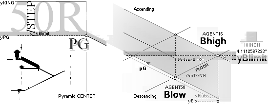
Difference (Petrie’s EAST 35.00) : 0124692565’’¦ 0.01:
The difference 35.01 – 35.00 = 0.01’’ lies well within Petrie’s tolerance.(± 0.60’’).
Petrie verified.
EARTHrJCIRCLE defines Petrie’s value.
yKING: dSTEP
yKING 1693.20:
![]()
Explain yKING 1693.1777299950’’: CheopsATLAS2024.ods Tabell2 A90
yKING = yPG + (50R + yBlimit) = yPG + dSTEP
= 1693.1777299950’’ ¦ 1693.18
Difference:
The difference 1693.20 – 1693.18 = 0.02’’ lies well within Petrie’s tolerance.(± 0.60’’).
Petrie verified.
EARTHrJCIRCLE defines Petrie’s value.
dSTEP — upper Gallery Ramp end ¦ dSTEPcalc ¦ yKING ¦ yKINGcalc
TUNGAL: collective illustration
— SCALE: 2pixel/1’’
———————————————
BUARM ¦ yATH ¦ yBarm
¦ bOFFSET ¦ yBlimit
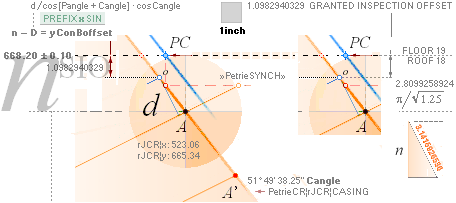
PANGLE (AGP’)
HANGLE (HAPetriepyramidBase)(AHA’)
n ¦ SIO ¦ y18ROOFconsequences ¦ yConBoffset
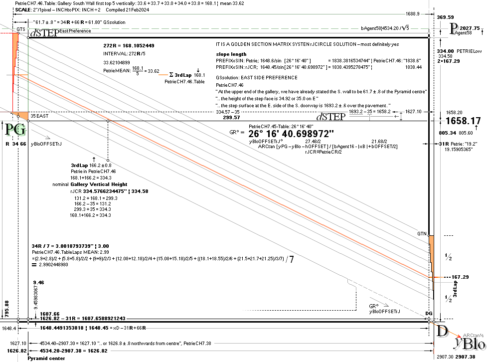
This
drawing — after Flinders Petrie’s measures and tolerances on the Cheops
Pyramid details (1881-1883) — implies parallelism between the Petrie
measured (GR° = 26° 16’ 40’’) Gallery Ramp floor slope, and the Petrie limited
measure of the South wall Gallery Roof top pitch point details (GTS, illustration left top).
The (Nominal) Gallery Roof sloping
angle (GR°) holds only on that presumption and implication of
parallelism.
—
As Petri puts it himself (”The roof of the gallery and
its walls are not well known, owing to the difficulty of reaching them”)
the Gallery metrics are only partly known (through the Petrie work group
1883). If any concordant additional 2 decimal inch measures (0.01’’ = 0.000254 M = 0.254
mM) with specified tolerances have been made since, these are not known
here. In general (available Internet sources 2024) the overall Cheops
Pyramid Gallery details are poorly represented by the type Petrie thorough
accounted for metric quantities; Stated quantities without a proper description
of the measuring technique, have no value in this presentation (owing to the
flora of less ambitious Cheops Tourists never mentioning/relating their sources).
THE GALLERY DETAILS — Cheops Pyramid
¦ Flinders Petrie’s measures [ 1881-1883 ]
https://www.ronaldbirdsall.com/gizeh/petrie/c7.html#46
—
Petrie’s text has no mentioning of a parallelism between Gallery roof and ramp
floor. Petrie’s calculated Gallery roof length
is hence implied from Petrie’s Gallery ramp floor measures.
MAYBE THE MOST CONVINCING
The D-point — not quite the
level of entrance to the Queen passage floor, but close
xGalleryNORTH-yQueenFLOORin
yMidQueenChamberPoint = P/2 — x = PyramidCenter
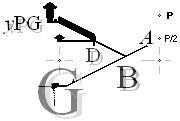
THE GEOMETRIC-TRIGONOMETRIC reasoning behind (EGSf)
(FULLY PETRIE CERTIFIED CALCULATED QUANTITIES ¦ TP26)
is somehow demanding to follow (ExplainDetails) on the specific equations unless already familiar. Not that the equations as such are complicated. But as these sometimes however tend to be extensive (easy to lose track of contemporaneous many balls in the air WHILE reckoning .. before getting to the point: good memory focus training);
— The reader (and the author) becomes easily tired — unless driven by a high level of motivation (high — very high — navigation focus).
— You know: talking to the passenger WHILE driving (90KM/h = 25 M/S);
— Not seldom being noted until crashing (Several Hollywood DVD movies give examples).
Cure: unless focused on »Car Now Moving»: leave it in the garage.
(Diet on much fruit and vegetables greatly increases mental navigation focus: faster, clearer, tighter, higher degree of daily comfort and health, most certainly yes).
A SIMPLER WAY OF EXPOSING THE POINT — Recursive Golden Section Constants, proving the Petrie concordances — is as below (»easy to proof-read»):
— The (geometrical-mathematical) complicated becomes compressed on five (simple) combining constants: 1. TanA • 2. bAgent16 • 3. bAgent58 • 4. R • 5. 18 ¦
We note that bOFFSET =
bAgent16 — bAgent58.
Definitely more easy to remember as a proof (√5 is R-integrated).
Explaining the D-point Petrie
concurrence:
xyD: QUEEN CHAMBER FLOOR PASSAGE HORIZONTAL and NORTH
GALLERY VERTICAL COORDINATE xyPOINT — D
TERMS: b16 = b¦Agent16
¦ TanA = ½ ¦ The18 — SEE NeutronSquare
[EARTHrJCIRCLE
integrated]: calculating atomic masses from atomic mass defects, comparing
experimental
USES: RECURSIVE CONSTANTS: TanA ¦ b¦Agent16 ¦ R = (-1+√5)/2 = 2/(1+√5): 1/R = 1 + R
¦ 18 ¦ bOFFSET
--------------------------------------------------------------------------------------
xD =
OpenOFFICEcellCodeSWEDISHedition
((( bAg16*(1/ROT(5) - GSR^3 - ROT(0.8)*GSR^4))-
-TanA*(( -bAg16*(GSR/ROT(5) + GSR^5 + ROT(0.2)*GSR^4)) + bOFFSETx + 18/2))-
(-xBhigh- (1/GSR) * ( -bAg16*(1 - 1/ROT(5)) + bOFFSETx/2)))/(1/GSR- -TanA)
=
((( b16*(1/(√5) - R^3
- (√0.8)*R^4)) - -TanA*( ( -b16*(R/(√5)
+ R^5 + (√0.2)*R^4) ) + bOFFSETx +
18/2)) - (-xBhigh - (1/R) * ( -b16*(1 - 1/(√5)) + bOFFSETx/2)))/(1/R
- -TanA)
= -2907.3786301931’’ ¦ 2907.38
=
2907.3786301931’’ ¦ 2907.38
2907.30’’ ±
0.60’’ ¦ PETRIE (PetrieCH7.39):
difference: 0.08 ¦ approved
--------------------------------------------------------------------------------------
yD = OpenOFFICEcellCodeSWEDISHedition
bAg16*(1/ROT(5) - GSR^3 - ROT(0.8)*GSR^4) - -TanA*( - bAg16*(GSR/ROT(5) + GSR^5 + ROT(0.2)*GSR^4)
+ bOFFSETx + 18/2) + -TanA*M14
=
b16*(1/(√5)
- R^3 - (√0.8)*R^4)) - -TanA*( - b16*(R/(√5) + R^5
+ (√0.2)*R^4) + bOFFSETx + 18/2) + -TanA*xD
= 852.8245796313’’ ¦ 852.82
= 852.8245796313’’ ¦ 852.82
852.60’’ ±
0.30’’ ¦ PETRIE (PetrieCH7.39):
difference: 0.22 ¦ approved
--------------------------------------------------------------------------------------
Compare direct R multiples:
xD: 4704R =
2907.2318830795 ¦ 2907.23 PetrieCH7.39:
2907.30’’ ± .60’’ DIFFERENCE:
0.07 ¦ still OK
yD: 1380R = 852.8869044749 ¦ 852.89 PetrieCH7.39: 852.60’’ ± .30’’ DIFFERENCE: 0.29 ¦ still OK
Explaining Golden Section Matrix Solution
fits:
General: THE READER SHOULD HAVE A BASIC
DRAWING/IMAGE HANDLING PROGRAM — following, testing, making personal
progress/discovery IF INTERESTED, if time ...
A SUCH DOES NOT EXIST IN ANY FREE VERSION AT
INTERNET what we know — EXCEPT HERE a DELPHI4 Windows API developed basic image
handling program — which however Microsoft does NOT support a FULL data
coverage to: NO AVAILABLE ORIGINAL WINDOWS API HELP FILE CONNECTIVITY —
Microsoft killed all such connectivity around 2015. So, in principle: a free
fine basic Windows API image handling program exists — but Microsoft does not
allow a full programmatic description. Say again. So:
— Where are any established
decent cooperators for a free and full tool
development in concern of humanity’s basic science insights in mathematics? I
see none.
”Restart your computer, or we
will do it for you”; ”Pick a time”; ”Let’s
kick off”; ”Fuck you asshole”. Microsoft. Computers were for humanity,
science. Not for slavery trade. Say.
Stop
killing humanity. Box. Dark. The sooner Microsoft 2015+ leaves this planet the better [ Trafficking
humanity: cannot handle humanity, computers,
mathematics, physics ]: mind liberation of humanity. Disclaim:
— Is world jurisdiction any other than a
Microsoft/GOOGLE bought bitch? Police. Prosecutor. Court. Parliament.
Surveillance: mindRAPE: Not one word human right
recognition. Not a sound. 24/7.
————————
Easy
function: R rotate in 90° steps ¦ i invert ¦ Ctrl+D duplicate ¦ H flip horizontal¦ V flip vertical ¦ A fleet move AND ¦ C fleet move COPIED ¦ W fleet skip white ¦ M fleet move/merge: NumPad ± :
0-100% ¦
HowWeDoIt.
Ctrl + 1 2 3 5: MoveMatrix 1 5 20 pixels Half
Screen. FULL IMAGE HANDLING ANALYZING CONTROL:
Ctrl + Arrows: MOVE AS SET.
NOTE: The free OpenOfficeCalc
does not support PIXEL coordination. Meaning: Very problematic in synchronizing
Exact Pixel Drafts/Illustrations/Diagrams.
————————
SCALE: 4534.40’’/100pixel — after the Flinders Petrie Labor Group measures
[ CheopsSOURCES
] of The Cheops Pyramid [1881-1883].
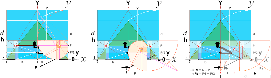
TheDpoint: HOW THE CROSSING LINE COORDINATES WERE
GOLDEN SECTION ORGANIZED — IN SEARCH OF A PETRIE ACCORDING VALUE — for P4:
See Pn-GS series unless already
familiar.
— The intersection xyD-point — for Pn-valies, see GoldenSectionPnMATRIX:
The xPb = b — P x-coordinate part is pushed horizontally positive by bAgent16¦58
with bOFFSET/2
= 21.68/2. The Golden Section ARCtan 1/R PbLINE as
illustrated above [ CheopsATLAS 2020 orig. TP26].
The xPA = –[piLINE + b¦Agent16(b6 + b5√0.2)] x-coordinate part is pushed horizontally positive by bAgent16¦58
with bOFFSET
+ 18/2.
The Golden Section —ARCtan½ Blow ascending passage line.
Explain:
— THE GOLDEN SECTION MATRIX SYSTEM AS SUCH HAS —
what we know — NO DIRECT PlanetEARTHrJCIRCLE CONNECTIVITY: Planck constant,
c in vacuum, neutron mass density, Earth mass.
So a such rJCIRCLE adjustment to GS matrix system is
allowed — as long as its end station falls within the Petrie given tolerances.
And it so does. Compare direct R multiples:
xD: 4704R =
2907.2318830795 ¦ 2907.23 PetrieCH7.39:
2907.30’’ ± .60’’ DIFFERENCE:
0.07 ¦ still OK
yD: 1380R = 852.8869044749 ¦ 852.89 PetrieCH7.39: 852.60’’ ± .30’’ DIFFERENCE: 0.29 ¦ still OK
xD: xQUEENGAL DISTANCE FROM PYRAMID NORTH BASE — i.e.; North [ lower ]
Gallery vertical end wall:
(b16[1/√5
– R^3 – R^4√0.8] + TanA[–b16(R/√5
+ R^5 + R^4√0.2) + bOFFSETx
+ 18/2] – (–xBhigh
– (1/R)[–b16(1 – 1/√5] + bOFFSETx/2)))/(1/R +
TanA)
yD: yQUEENGAL THE LEVEL LEADING TO THE TERMED QUEEN’S CHAMBER:
b16(1/√5
– R^3 – (√0.8)*R^4)) + TanA(–b16(R/√5 + R^5 + (√0.2)*R^4) + bOFFSETx + 18/2) – TanAxD
THE FIVE RECURSIVE CONSTANTS:
TanA = ½ ¦ Golden Section
Matrix System Solutions through ARCtan½
b16 = 4555.88’’
R = GoldenSectuinConstant (1+√5)/2
18 = The18
bOFFSET(x) = b16 — b58 = 21.68
xBhigh =
rJCR¦b16High = -1499.7016293661’’ ¦ 1499.70
=
b16(1/2(√5) + R^3/√5)
=
b16(1/2 + R^3)/√5 direct GS-algebraic = P(1/2 + R^3)
= 1499.7016293661 ¦ as a positive y-coordinate
=
-1499.7016293661 ¦ the actual negative
x-coordinate xBhigh
Discovered by arithmetic identification.
Compiled:
xyD
Petrie ¦ PetrieCH7.39:
x ¦ 2907.30’’ ± 0.60’’
y ¦ 852.60’’ ± 0.30’’
---------------------------------
xyD rJCR:
x ¦ 2907.38’’ ¦ -2907.3786301931 Difference: 0.08 approved
y ¦ 852.82’’
¦ 852.8245796313 Difference: 0.22 approved
xyD multiR
direct GS solutions: R =
2/[ 1 + √5 ] Golden Section Matrix System:
x ¦ 2907.23 ¦ 2907.2318830=4704R Difference: 0.07 approved
y ¦ 852.89
¦ 852.8869045=1380R Difference: 0.29 approved
xyPG
Petrie ¦ PetrieCH6.46:
x ¦ 4534.40’’
± 0.25’’ half
Pyramid base
y ¦ 1658.20’’
± 0.60’’ 1693.2
— 35 = 1658.2
---------------------------------
xyPG rJCR:
x ¦ 4534.20’’ ¦ 4534.1965759686 Difference: 0.20 approved
y ¦ 1658.17’’ ¦ 1658.1652607385 Difference: 0.03 approved
xyPG multiR
direct GS solutions: R =
2/[ 1 + √5 ] Golden Section Matrix System:
x ¦ ——
y ¦ 1658.19 ¦ 1658.185192=2683R Difference: 0.01 approved
Conclusion:
PETRIE’S VALUES CAN BE CALCULATED in general FROM
THE GS
GOLDEN SECTION MATRIX SYSTEM’S rJCIRCLE
preference Pyramid Agents16¦58
and in special cases directly from multiple R,
the Golden Section Matrix Systems Constant 2/[ 1 + √5 ] = [ –1 + √5
]/2.
CHEOPS PYRAMID DETAILS after Flinders Petrie’s
measures [1881-1883]
SCALE: 100pixels/4534.40’’ — half
Pyramid base.
TheDpoint ¦ xyD ¦ EGSf ¦ ExplainDetails
¦ xyDalgebra ¦ The5 ¦ Compiled
RESOLVING PETRIE’S GALLERY ROOF MEASURES
RESOLVING PETRIE’S GALLERY ROOF MEASURES
GalHeightIssue ¦ SmythTol ¦ GallerySouthWall ¦ GalleryAnglePETRIE
¦ TrigMETH ¦ GalleryRoofSlopingAngle
¦ GalRoofRampDetails
¦ GalleryRAMP ¦ PetrieGalRoofPros
¦ PetrieGalleryRoofDetails
¦
GalleryRoofInvest ¦ SawToothRoofing
¦ iDSangle ¦ NominalGalleryHeight
¦ GalForceConstruct
¦
GalHeightIssue: GalRES
Revisiting Petrie’s Cheops
Pyramid Gallery
PETRIE GIVES NUMBERS EXPLAINING THE ACTUAL
GALLERY HEIGHT— BUT NEVER SO MENTIONED: 334.30’’ [ ± 0.80]
PETRIE DOES ACCOUNT FOR THE VALUES — BUT NEVER
ADDS THEM UP — and never explicitly states The Angle 26° 16’
40’’ —
but writes it in PetrieCH7.39.Table: ” Variations
from mean axis of 26° 16' 40'' altitude": Never mentioned in the text.
Petrie-Smyth measuring
solution (1883)
PetrieCH7.46.Table Laps, beginning from the South Gallery Top, measures (plumb line) the FIVE FIRST vertical South wall overhanging blocks down to the bottom edge of the third Lapse on the sum 168.1’’ (no specified tolerance).
” The roof of the
gallery and its walls are not well known, owing to the difficulty of reaching
them. By means of ladders, that I made jointing together, I was able to
thoroughly examine both ends and parts of the sides of the gallery.”,
PetrieCH7.46.
Lsum: 168.1
= 33.6 + 33.7 + 33.0 + 34.0 + 33.8
— Petries values in his Laps table, first 5 from
Gallery roof top South
Nominal Petrie-Gallery Height: 334.3 (± 0.8)
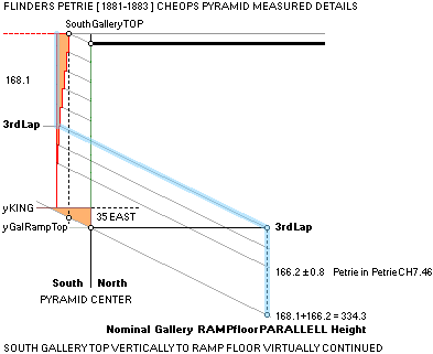
———————————————
DATASOURCE:
https://www.ronaldbirdsall.com/gizeh/petrie/c7.html - 46
PetrieCH7.46, same text section,.also reports in discussing Lap 3:
” The remarkable
groove in the lower part of the third lap, along the whole length of the
sides ..”;
” According to Prof. Smyth
the mean [p. 74] height of this lap above the gallery floor is
166.2 ± .8 vertically”.
https://www.ronaldbirdsall.com/gizeh/petrie/c7.html - 46
Adding the two measures together,
roof to floor, yields a nominal Gallery height
334.3 ’’ = Lsum+ Smyth = 168.1 + 166.2 ¦ ± 0.8
GallerySouthWall: GalHeight
GALLERY SOUTH WALL
Golden section rJCIRCLE
solution (Feb2024)
Verticals:
272R = 168.1052449400’’ ¦ 168.11 ; Petrie5FromTop 168.10 = 33.6 + 33.7 + 33.0 + 34.0 + 33.8
÷ 5 = 33.6210489880’’ ¦ 33.62 ; ÷ 5 =
33.62 ¦ same value
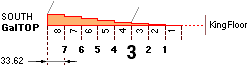
Petrie’sTable PetrieCH7.46Table Laps — Petrie never mentions the sum, we have to sum it ourselves as above:
https://www.ronaldbirdsall.com/gizeh/petrie/c7.html - 46
Horizontals:
34R = 21.0131556175’’ ¦ 21.01 ;
÷ 7 = 3.0018793739’’ ¦ 3.00 ;
PetrieCH7.46.Table Laps:
190.92 =
2.9+2.8 + 5.8+5.8 + 9+9 + 12.08+12.18 + 15.08+15.18 + 18.1+18.55 +
21.5+21.7+21.25; averaged;
20.9317142857 = (2.9+2.8)/2 + (5.8+5.8)/2/2 + (9+9)/2/3
+ (12.08+12.18)/2/4 + (15.08+15.18)/2/5 + ((18.1+18.55)/2/6 +
(21.5+21.7+21.25)/3/7)
÷ 7 = 2.9902448980’’ ¦ 2.99
Petrie mentions 61.7 ± 0.8 at 5 occasions (PetrieCH7.45¦46¦47¦64) connected to ”the great step” on the King’s floor. The central quote in PetrieCH7.46:
” At the upper end of the gallery, we have already stated the S.
wall to be 61.7 ± .8 of the Pyramid centre”,
https://www.ronaldbirdsall.com/gizeh/petrie/c7.html - 46

The GS
solution uses the 61.8’’ = 100’’R as
a unit:
Same values.
R = (–1 + √5)/2 = 2/(1 +
√5) = 0.6180339887 ¦ 1/R = 1 + R ¦ GoldenSection Fractal Matrix
System Constant
Gallery height:
334.58’’
hG = 334.5766234475’’ ¦ 334.58 ;
Petrie-Smyth: 334.30F DIFF: 0.28 = 7.112 mM [Smyth tol.:
± 0.8’’]: approved
yBlimit
— dSTEP associated ¦ recursive constant connecting TunnelCross
and Pyramid Casing Entrance values:
Gallery ramp step face height — yPG:
1658.17’’
———————————————
Agent 16¦58 CONSEQUENTIAL MATHEMATICS
As noted: It is impossible to receive Petrie concurrent
values without the (matrix) EARTHrJCIRCLE Golden Section
Cheops
Rectangle bd=h² mathematics agent.
— With it, as noted: »a walk in the park». Resolution217.
MiUNIT: recursive constants
rJ/100R√16000
= 0.025400718 an automatic 0.0254 M unit if so rounded on the
Planck Dmax mJ constant. Without this arithmetics: no way. 1’’ = 0.02540
M.
GalleryAnglePETRIE:
GalSouthWall
GALLERY Ramp/Roof SLOPING ANGLE
HOW PETRIE MEASURED IT
Gallery RAMP Floor sloping angle:
Galflora°
Petrie measuring solution
(1883):
Petrie mentions it once
in his table PetrieCH7.45.
[ Petrie’s PetrieCH7.45.Table
stated 26° 16’ 40’’] — also so never mentioned in Petrie’s text.
But it is never
mentioned in the text:
26° 16’ 40’’ =
26.2777777778°
How Petrie found the Gallery
ramp sloping angle, as quoted
————————————————————————
TRIGONOMETRIC MEASURING
METHOD for finding THE SLOPING ANGLE along s
known by two fix
s-separated points [sHigh, sLow] trough horizontal angles A+B
and the distance to sLow
[a].
— Apparently what Petri
had to calculate on the sloping Cheops Pyramid Gallery Floor Ramp, provided
enough precise instrumental angular values [A and B], and distance measures [a
and s]. Quote below.
TrigMETH: GalAngPetrie
Trigonometric method:
HOW PETRIE MEASURED/CALCULATED THE GALLERY RAMP FLOOR SLOPING ANGLE (GR°)
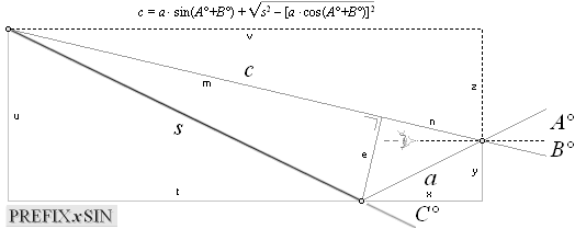
a·sin(A+B) =
n; a·cos(A+B) = e; s² – e² = m², = s² – [a·cos(A+B)]² :
n + m = c, = a·sin(A+B) + √s² – [a·cos(A+B)]².
PREFIXxSIN ¦ 1/sin=secans,
1/cos=cosecans ¦ in MAC: 1/sin=cosecans, 1/cos=secans
PREFIXxCOS
— The student should handle both — with same ease
as knowing the difference between left and right:
♦
Just switch the labels SIN/COS — applies as well to imaginary
trigonometric basic algebra. TAN not affected.
— We are broad seeing beings: sine: basic horizontal. Not vertical. »A walk in the park».
—————————————————————————————————————
c = a · sin(A°+B°)
+ √s2 – [a · cos(A°+B°)]2 ;
v = c · sinB°
z = c · cosB°
y = a · cosA°
x = a · sinA°
t = v – x
u = y + z
C° = atan(u/t)
= atan([y + z]/[v – x])
= atan([a · cosA° + c · cosB°]/[c · sinB° – a · sinA°])
GALLERY ANGLE DETAILS:
PetrieCH7.39:
” 39. For the angle of the passage, and its
straightness, it will be well to consider it all in one with the gallery floor,
as they were gauged together all in one length. The angle of slope I did not
observe, as I considered that that had been settled by Prof Smyth; but the
azimuth was observed, by a chain of three theodolites, round from the entrance passage.
The straightness was observed by offsets to floor and side all along it, read
from a telescope at the upper end of the plug-blocks. When I came to plot the
results, I found that there were no measures taken at the point where Prof.
Smyth's theodolite was set up. The sloping
floor is nowhere, having been entirely cut away at the beginning of the gallery;
and the top of the ramp (to which the theodolite had been referred) was not
offsetted by me, nor was its slope measured by Prof Smyth's clinometer for 300
inches from the place. Hence we cannot say exactly
what direct relation the theodolite bore to the passage; but we can obtain the angle of slope very satisfactorily, by taking the angles observed to signal at bottom of ascending
[p. 65] passage, and to signal at top of gallery, and then (knowing the
distances of these signals) calculate the angle of slope from signal to signal.”,
PetrieCH7.39 — THE GALLERY DETAILS —
Cheops Pyramid ¦ Flinders Petrie’s measures [ 1881-1883 ]
https://www.ronaldbirdsall.com/gizeh/petrie/c7.html#39
http://www.ronaldbirdsall.com/gizeh/petrie/index.htm
Petrie never mentions the Gallery Ramp Floor
sloping angle as such except in his table PetrieCH7.39, accounting for the
floor’s variations by successive positions bottom to top relative this angular
axis
Petrie’s Gallery Ramp Floor sloping angle in PetrieCH7.39.Table
” Variations from mean axis of 26° 16' 40''
altitude":
26° 16’ 40’’
from where Petrie then calculates the Gallery
length, using furter measurements:
Petrie mentions no tolerance on this measured
angle.
Petrie uses this angular
Gallery Ramp floor slope angle value to calculate the sloping length of the
Gallery (roof — implied an unproven
parallelism) in total (Petrie’s PREFIXxCOS):
hypoGal = xGal ÷ cosGalRamp°
= 1648.4/cos
26° 16’ 40’’
= 1838.3816534744’’ ....... ; 1838.38
PetrieCH7.46:
= 1838.60 ...................... ; We have better
arithmetic aid 2024 compared to Petrie’s 1883
” From this the length
of the roof of the gallery is 1688.9 – 40.45 = 1648.4
horizontal, or 1838.6 sloping.”, PetrieCH7.46.
THE GALLERY DETAILS — Cheops Pyramid
¦ Flinders Petrie’s measures [ 1881-1883 ]
https://www.ronaldbirdsall.com/gizeh/petrie/c7.html#46
GalleryRoofSlopingAngle: TrigMETH
Golden section rJCIRCLE PetrieValue-solution
Golden section rJCIRCLE
solution (Feb2024)
Gallery RAMP sloping angle ¦ Petrie’sSolution
CheopsGalleryRampAngle: 50% Reduced size, see 100% original sice in
separate PNG-file: CheopsGRAngle.
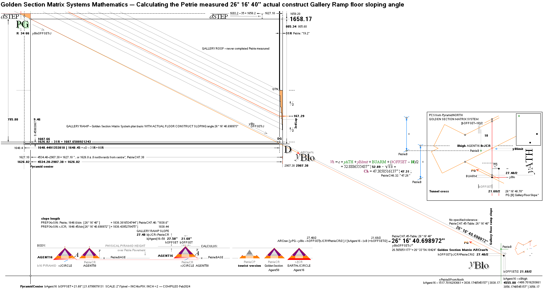
Golden Section Matrix Systems Mathematics — Calculating the Petrie measured 26° 16’ 40’’ actual construct Callery Ramp floor sloping angle:
————————————————————————————————————————————————————————————
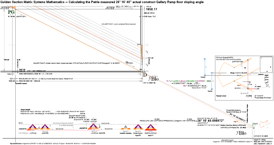
The Golden Section Matrix Systems calculated
B-region coordinates have — offseted — provisiopn for defining the TrigMETH
Petrie measured Gallery ramp sloping angle 26° 16’ 40’’. See original size
image in CheopsGRAngle.
How:
Offsetting the yBlo point (defining the yPG point) from xyB-results with
VerticalUP y
= 27.48’’/2 = [hOFFSET rJCR — PetrieCR]/2
Southward x
= 21.68’’/2 = [bOFFSET Agents 16¦58]/2
Resulting angle from the original Golden Section System’s ARCtan½:
26° 16’ 40.698972’’ = GR°
yPG.yBloOFFS° =
26° 16’ 40.698972’’ = 26.2779719366°
CheopsATLAS2024.ods Tabell2 A142:
GR° = ARCtan (yPG – yBlo – [hOFFSET= h¦rJCR – h¦PetrieCR]/2) / (bAg16 – Abs(xBhigh) + [bOFFSET=bAg16 – bAg58]/2)
Fully Gallery-B-region scale illustrated in CheopsGRAngle.
Further GS solutions, by calculating the Gallery Roof length from the same Petrie provisions, yields
hypoGalleryRoof =
1838.4395278475’’ ¦ 1838.44 DiffPetrie:
0.06’’ approved
[PetrieGalHeight tolerance: 0.80]
GalRoofRampDetails:
GalAng
GALLERY ROOF SAW-TOOTH MORPHOLOGY:
Gallery roof saw-tooth morphology:
MiUNIT: recursive
constants GOLDEN SECTION GS
MATRIX SYSTEM SOLUTIONS
rJ/100R√16000
= 0.025400718 an automatic 0.0254 M unit if so rounded on the
Planck Dmax mJ constant. Without this arithmetics: no way. 1’’ = 0.02540
M.
100’’R = 61.8033988750’’ ¦ 61.80 ; 61.80/3 = 21.60:
Petrie — directly on our GoldenSection 100’’R=61.8’’ MiUNIT:
” .. here the extreme lines are .. with a
supplementary line 61.8 [or 3 × 20.6]
..”,
PetrieCH7.63
https://www.ronaldbirdsall.com/gizeh/petrie/c7.html#63
:
” This cubit is the
regular cubit of 20.6”, PetrieCH7.43 — 20.6 mentioned at 8 places in CH7
— Change the URL #section number to
actual section number for direct URL access to the Birdsall Petrie archives
— or scroll through the entire Chapter 7 (or others) from
http://www.ronaldbirdsall.com/gizeh/petrie/index.htm
” Probably
the base of the chamber was the part most carefully adjusted and set out; and
hence the original value of the cubit
used can be most accurately recovered from that part. The four sides there
yield a mean value of 20.632 ± .004,
and this is certainly the best determination
of the cubit that we can hope for from the Great Pyramid.”,
PetrieCH7.52.
” By plumb-line measure at the S. end, the roof on
the E side is inside the floor edge (or overhangs) 20.50, and on the W. side
20.40. On the S. end (eliminating the lean) the projection is 20.9, and on N.
20.4; mean of all, 20.55, for the sum of the
seven projections of the laps, or one cubit, the laps being then one
palm each in breadth. Thus the laps overhang
the ramps along the gallery sides, and
the space between the ramps (2 cubits), is equal to the space between the walls
at the top.”,
PetrieCH7.46.
GalleryRAMP: GalRoofRampDetails
” The width of
the top of the gallery is 40.9 at N., and 41.3
at S. end.”,
PetrieCH7.46.
” Pyramid gallery
widths ........ 82.42 ........ mean diff. .44”,
PetrieCH6.30 on THE TRIAL PASSAGES
![]()
Clean-DRAWN and size armed Detail from an
older [1890-1900] unknown photographic source (frequently used by a
diversity of Cheops Pyramid Tourists, source found as below): The Cheops
Pyramid Gallery Ramp details:
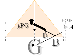
SCALE after Petrie’s measures [
1881-1883 ]: 4534.40’’/100pixels—
Cheops Pyramid, inner details
” The trial
passages Pl. iii b are a wholly different class of works to the
preceeding, being a model of the great pyramid passages, shortened in length,
but of full size in width and height. Their mean dimensions — and mean
differences from those dimensions — as against the similar parts of the Great
Pyramid, are —”, continued in Petrie’s table PetrieCH6.30,
https://www.ronaldbirdsall.com/gizeh/petrie/c6.html#30
— Petrie does not tell what ”the trial passages” is.
Other sources explain.
Note: THE TRIAL PASSAGES — a gauging test model directly
cut out of the solid rock, no stone masonry:
” Just a
stone’s throw from the Great Pyramid we find a set of very odd passages that
are very rarely discussed these days, yet
which have puzzled some of the greatest minds ever to have explored the
Giza plateau.”,
TheHereticMagazine.com,
THE TRIAL PASSAGES: A MESSAGE IN STONE?, 2Nov2017
” Petrie
believed that they had been built before work on the Great Pyramid commenced,
as an attempt to mock-up the layout of the internal passages in the pyramid.
Therefore they were named the Trial Passages”.
Older unidentified PHOTO SOURCE IDENTIFIED:
THE
GREAT PYRAMID PASSAGES AND CHAMBERS
Volume
1 by John and Morton Edgar, 1910
found
through a Danish web site on Cheops Pyramid Feb2020
THE
KHUFU PYRAMID — GRAND GALLERY, Stefan A. H. Holmgren (1988+)
http://khufupyramid.dk/inside-dimensions/grand-gallery
A complementary value to the 4 × 61.8/3 = 82.4 value is the Golden Section Matrix system’s 5×P11 = 5 × (bAgent58 = 4534.20’’)R11–1/√5 = 82.4344878911’’¦ 82.43.
PetrieGalRoofPros: GalRAMP
TAKING ALL THE ABOVE 100R MENTIONED INTO
CONSIDERATION:
Petrie has already settled the main proportions:
THE SOUTH TOP GALLERY ROOF
ARITHMETIC-TRIGONOMETRIC MORPHOLOGY
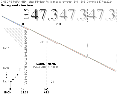
Petrie [ what we
know: never mentions the Golden Section complex ] refers his
measured inch vales — no specified tolerance
— beginning from the visible South Gallery Top, left top above:
0 14.5 47.4 61.9 MeanSlab 52.2
With the Golden Section MiUNIT 100’’R = 61.80’’ we would test a
corresponding suggested
0 14.5 47.3 61.8 MeanSlab 52.2
Namely — using recursive constants if possible —
the Ch
= 47.31’’ [
Petrie 47.26 ]
”(5)
entrance passage height 47.26.”. [ ± 0.17’’
]
tunnel/corridor parallel height, leading further
to the tunnel entrance-casing 19th course Petrie concurrent values [37.97,
Petrie 37.94 in PetrieCH6.32].
PetrieCH7.46 — GALLERY DETAILS:
” The roof
stones are set each at a steeper slope than the passage, in order that the lower edge of each stone should
hitch like a paul into a ratchet-cut in the top of the walls; hence no stone can press on the one below it, so as
to cause a cumulative pressure all down the roof; and each stone is separately upheld by the side
walls across which it lies. The depth of two of these ratchet-cuts, at
the S. end, I measured as 1.0 and 1.9 to 2.0; and the
angles of the two [p. 73] slabs there 28° 0' to 28° 18', and 27° 56' to
28° 30', mean 28° 11'; which on a mean slab
52.2 from N. to S., would differ 1.74 inches from the passage slope. The
edge of the southernmost slab is 14.5 from the
S. wall; the next slab is 47.4 from N. to S.”
THE GALLERY DETAILS — Cheops Pyramid
¦ Flinders Petrie’s measures [ 1881-1883 ]
https://www.ronaldbirdsall.com/gizeh/petrie/c7.html#46
http://www.ronaldbirdsall.com/gizeh/petrie/index.htm
Petrie — no specified tolerance:
14.5 + 47.4 = 61.9
Petrie’s specified Gallery RooF SLAB angle 28° 11’
—
GalleryRoofInvest: PGRP
18Feb2024 — SEEKING AN EVENTUALLY CLEAR PICTURE OF
THE SITE @CHEOPS PYRAMID after Flinders Petrie’s measures 1881-1883, THE
GALLERY DETAILS
INVESTIGATING PETRIE’S REPORTED SLAB DETAILS:
IF WE ARE TALKING REASONABLY EQUALLY SHAPED AND
DIMENSIONED DETAILS, PLACED IN A ROW, MORE OR LESS SLOPING: [ it is implied in the Gallery roof, only
partly described ]
The Petrie specified [ PREFIXxSIN ]
— no specified tolerance — beginning from the
visible South Gallery Top:
S° = 28° 11’
0 14.5 47.4 61.9 MeanSlab
52.2 ¦ 47.4/sinS° =
53.77558653’’ ¦ 53.78
with the Golden Section MiUNIT 100’’R = 61.80’’ correspondingly
suggested
S° = 28° 11’
0 14.5 47.3 61.8 MeanSlab 53.66 ¦ 47.3/sinS° =
53.66213592’’ ¦ 53.66
is so trigonometrically vindicated — given the
named provisions:
SawToothRoofing: GalRoi
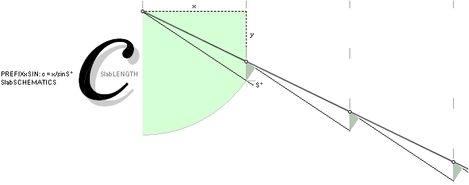
Given x=43.4 or even 43.3 on the S° angle 28° 11’ there
is no trigonometrically uniformly shaped parts possibly conforming to the
Petrie stated
”.. mean 28° 11'; which on a mean slab 52.2 from N. to S., would differ 1.74 inches from
the passage slope”,
PetrieCH7.46.
52.2 inches between endponts of a slab.
Given the x value in this case, the slab lengt [ c
] cannot be shorter than 53.7. Definitely not 52.2 — provided equally shaped
and dimensioned slab block parts.
What we
know, no such prfecise information exists — until measured in detail. Petrie
only refers his measure on two or three slabs at the south gallery roof top —
and there should be some 35 of them, south roof top to north roof bottom.
We will
have to wait for such data before any further.
iDSangle: STR
At first:
Identifying Petrie’s Slab sloping angle S° = 28°
11’
The GOLDEN SECTION rJCIRCLE MATRIX SOLUTION:
We use [ the Petrie consolidated] MiUNIT 100’’R/3 = 20.60’’
[ Petrie’s
sometimnes used »one cubic» ]
as the y-coordinate on the xBhigh
Golden Section solution determined value, taken on the Agent16determined yPG triangle. It gives us
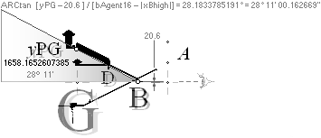
ARCtan(yPG —
20.6)/([bAgent16
= 4555.88] – | xBhigh |)
=
28.1833785191°
= 28° 11’ 00.162669’’
= GR° =
Galrosat° ¦ GalleryRoofSawTooth angle
And we can, what is known here, hardly find a more convenient and appropriate example of how gallantly the recursive Golden Section rJCIRCLE matrix system arithmetics works — with Petrie concurrent values.
SLAB DETAILS — to be
tested on further available measuring results from the Cheops Pyramid Gallery
ROOF details — data below from Petrie’s two or three measured Gallery roof slabs
—
no specified tolerance
USING THE GS SOLUTION SET 14.5 ¦ 47.3 ¦ 61.8 ¦
28°11’
PETRIE’S 14.5 ¦ 47.4 ¦ 61.9 ¦ 28°11’
SLAB DETAILS: theoretically reckoned from Petrie’s specifications — the actual overall details are unknown:
” The roof of the
gallery and its walls are not well known, owing to the difficulty of reaching
them. By means of ladders, that I made jointing together, I was able to
thoroughly examine both ends and parts of the sides of the gallery.”,
PetrieCH7.46.
https://www.ronaldbirdsall.com/gizeh/petrie/c7.html#46
Petrie mentions only two of the Gallery roof saw-tooth formed stone fittings (Petrie quoted on the gallery roof details) — on the south Gallery part only. The north lower part (illustrated TheDpoint) is partly on the construction leading in to the so called Queen’s chamber. The gallery floor has no representation there over some 8 horizontal meters. Meaning: The north Gallery lower wall has no direct Gallery ramp floor sloping angle reference point (in that the D-point at that point connects to the Queen’s chamber level). So, we have no complete measuring references over the entire Gallery region details. And the Gallery Ramp floor sloping angle has no direct measurable connection to any the actual floor (at all) at that TheDpoint; The Gallery Ramp slope cannot be directly measured from the D-point. As Petrie puts it (see TrigMETH):
” The sloping floor is nowhere, having been
entirely cut away at the beginning of the gallery; and the top of the ramp (to
which the theodolite had been referred) was not offsetted by me, nor was its
slope measured by Prof Smyth's clinometer for 300 inches from the place. Hence we cannot say exactly what direct relation the
theodolite bore to the passage; but we can obtain the angle of slope very
satisfactorily, by taking the angles observed to signal at bottom of ascending
[p. 65] passage, and to signal at top of gallery, and then (knowing the
distances of these signals) calculate the angle of slope from signal to
signal.”, PetrieCH7.39.
THE GALLERY DETAILS — Cheops Pyramid
¦ Flinders Petrie’s measures [ 1881-1883 ]
https://www.ronaldbirdsall.com/gizeh/petrie/c7.html#39
http://www.ronaldbirdsall.com/gizeh/petrie/index.htm
NominalGalleryHeight: iDSangle
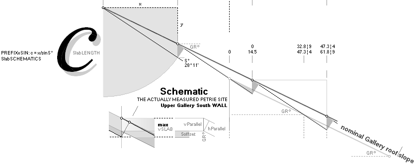
Introducing the term Nominal Gallery Roof height —
relative the extra Petrie measured slab pitches — will (here) relate to
Petrie’s actually Gallery roof top point on his referred South wall top — so we
would not have to bother on the actual slab pitches variations (some 2’’:
-0.61, + 1.38, if equally formed and spaced — which we do not know, only imply,
until more precise measuring data arrives).
Soffset, MaxVERTICALslab and Slab-PITCH Parallel DISTANCE:
Soffset = 14.5/(tanS° – tanGR°)
=
0.6100001567’’ ¦ 0.61
vSLAB = 47.3/(tanS° – tanGR°)
=
1.9898625801’’ ¦ 1.99
vPARA = vSLAB — Soffset
=
1.3798624234’’ ¦ 1.38
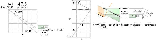
hPARA = vPARA/(tanGR° + cotS°)cosS°
=
1.2379473689’’ ¦ 1.24
GalForceConstruct: NomGalHi
This author’s idea of the actual construct — as
partly described by Petrie in PetrieCH7.46.
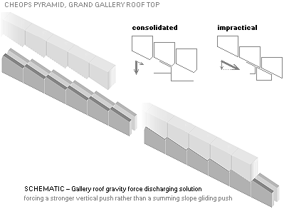
Petrie does not specify the metric meaning in his
use of ”on a mean slab 52.2” — the actual ratchet-cut’s measuring
reference point to its (Petrie 47.4 inches) opposed pitch. So we have a certain
margin to consider until more related (more thorough measuring data is
needed on the Gallery roof morphology).
Following the strict trigonometric ideal mathematics, Petrie’s specification of a mean slab length 52.2’’ does not match a mean horizontal slab interval (43.4’’, our preferred testing 43.3). The theoretical slab length value from 43.3¦4 is in PREFIXxSIN
sLEN = 47.3/sin(GR° = 28° 11’)
=
53.6621503168’’ ¦ 53.66
———————————————
sLEN = 47.4/sin(GR° = 28° 11’)
=
53.7756009517’’ ¦ 53.78
Any way we reckon, Petrie’s 52.2’’ mean slab does not match his mentioned mean ditto horizontal 43.4’’.
On the other hand (Petrie quoted on the gallery roof details), Petrie’s values refer only to the two first in the South part. Additional measuring data is needed for a complete picture.
FURTHER PETRIE MEASURED QUANTITIES CONFIRMATIONS BY THE EARTHrCIRCLE GOLDEN SECTION SOLUTIONS WERE GIVEN IN THE 2020 VERSION (CheopsATLAS), as tabled there: Queen’s and King’s chambers.
— By that time — Resolution217 was unknown then — we had issues on the gallery roof height details. It is now an archive, referring the details in our preceding works.
GalRES21Feb2024 — GALLERY RESOLUTION 2024 ¦ GalHeightIssue ¦
SmythTol ¦ GallerySouthWall
¦ GalleryAnglePETRIE
¦ TrigMETH ¦ PetrieHypoGAL
¦ GalleryRoofSlopingAngle
¦ GalRoofRampDetails
¦ GalleryRAMP ¦ PetrieGalRoofPros
¦ PetrieGalleryRoofDetails
¦
GalleryRoofInvest ¦ SawToothRoofing
¦ iDSangle ¦ NominalGalleryHeight
¦ GalForceConstruct
¦
In summing the impressions: We could easily say that
the above
———————————————
Resolution217 ¦ DETERMINING/testing THE CORRIDOR HEIGHT
¦ How Petrie Calculated THE ENTRANCE
¦ The height of the 19th course
¦ CONSEQUENCES ¦ Determining the B point
is the main construction plan of the
building, judging from the calculated results: Petrie
verified.
SOME READER MAY THINK OR ASK: Is this some kind of a magic?
— I don’t like Type Magic. (»Fancy Inexplainable Crap»).
— »Magic numbers .. magic equations .. ».
No. Most certainly NO.
— What is it then?
This author would say:
AS CLOSE AS WE CAN GET TO THE ANSWER
ARITHMETIC RESONANCES
»Life stuff».
— In biology — life chemistry (there are several examples [PearlBoatShell Nautilus Pompilius ¦ M74GS]) but also in our universe in general — the Golden Section Mathematics have good credit:
ARITHMETIC RESONANCES (The Atomic Universe)
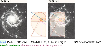
———————————————
M74GS ¦ Hale Observatory
—————————————————
It is NOT magic (which of course it is).
— It is an arithmetical resonance. See Resolution217.
Like a rare flower — on
orderly provisions, no messing around.
Compare The ITERATOR (IteratorMechanics): what is and what is not.
It takes ON CONVERGENT — or rejects DIVERGENT.
Basic Life biochemistry.
Or simpler: music. Symphony. Only those motivated enough pass.
Old stuff. Very.
(And someone knew it before us .. but modern corridors have a real hard time with that one, as they cannot handle even the present one, without killing the foundation: nature).
Summing ¦ M74GS — ARITHMETIC
RESONANCES
PyramidCoordinateSystemChEX
The PYRAMID COORDINATE SYSTEM
The
(1881-1883) PETRIE CHEOPS PYRAMID MEASURED ADOPTED PYRAMID COORDINATE SYSTEM
THE IDEAL CHEOPS RECTANGLE bh=h² PYRAMID BASIC COORDINATE PREFERENCE
SCALE: 248pixels/4534.40’’ — exaggerated
M° angle for clarity
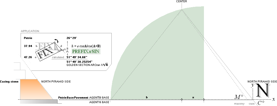
Agent 16 ¦ Agent 58 ¦ REMAINING CASING illustrated
M°
Suggested stone masonry angular slope — not the flat case C°.
Petrie (PetrieCH6.24, table: ”Casing stones in
situ, N side, by theodolite”) gives no comprehensible specification of the
remaining actual staircase masonry angular slope (Petrie’s
description of his measuring method, where, how and in detail, is partly
unclear,). He only discusses angular values associated with the original
now removed casing, with reference to measures (the actual table) on the few remaining
ground base casing stones (at the Pyramid’s north side). And concludes,
” N face, by entrance passage
mouth 51° 53’ 20’’ ±1’ ”.
Petrie does not clarify what
is meant by ”face” — if it is the FACE of the Pyramid we actually SEE NOW, the
actual staircase masonry — or Petrie’s IDEA of the Pyramid as ”CASING RESTORED”
in his PlateXI.4, as quoted;
The simple corresponding
PetriePlateXI.4
illustration — North side Pyramid wall:
— descending passage floor (A) line is (mirror, optically) reflected/diffracted on the outer original casing, giving a horizontal reference to The 19th Course and its decisive height (37.94’’). The parallel height (e) of the descending corridor reflects the thickness of the 19th course masonry. As Petrie states: several other Pyramids expose the same principle construct. See
PETRIE BREAKS THE ENIGMATIC ICE.

”The
diffractive effect” described by Petrie — from the entrance passage slope to
19th course height — was never observed in this first production 2017 (The rJCIRCLE Discovery). It was noted here
in UH first on the 2020 version (CheopsATLAS, ConPent),
after reading about Petrie’s studies on the nearby Pyramid constructions
(PETRIE BREAKS THE ENIGMATIC ICE). And first now Course19th in
this version (Jan2024), the 2020 version derived ”How Petrie reckoned the
Cheops Pyramid Entrance” trigonometric equation was tested in full on the
already Petrie given values. It revealed what was never before revealed.
Further below. It is sometimes strange how a revealing detail ”waits” until the
proper moment when it will give the most of its light — included the
possibility that the author got it all wrong. Because before that, »nobody
understands its full meaning». As experienced.
Petrie also (clearly, Petrie Plate9 ¦ partly Copied2017)
reports the general size of stones at the base to be larger (some 1.5 M high), extending
to the top smaller (some 0.5 M high). So it would be only rational (but here
with zero actual proof) if also the casing stones would have the same
constructive feature. Meaning (here with no proof): The stone masonry slope
(M°) should be slightly steeper (greater) in angle than the final (now gone)
outer flat casing (C°).
Application: PCS
The proof
Petrie’s own specified/measured values (Course19th)
eParallel = 47.26’’
h = 37.96’’ (Petrie calculated)
Passage° = 26° 29’
gives through the trigonometric connection
(in
this version it must be iterated, see 19thITERATED)
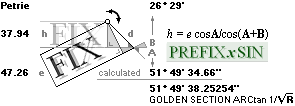
Modern academia writes the equation: h = e •
sinA/sin(A+B): see PREFIXxSIN
unless already familiar: With given ehB, A is solved:
Σ° – (acos[(h/e)cosΣ°] = A°) = B° ; Σ°
– B° = A° ¦ iterative solutions
in PREFIXxSIN
MAYBE THE LAND SURVEYING INSTANCES HAD NO KNOWLEDGE OF THE CONNECTION
AROUND 1880.
OR — AND — PERHAPS STILL UNFAMILIAR [ which indeed would be the strangest
..].
— That is: Petrie didn’t reckon The Site. Not at all. Only
partially on traditional simple direct trigometrics.
a flat casing angular value of
51° 49’ 34.66’’
AN ALMOST DIRECT GOLDEN SECTION CHEOPS RECTANGLE bd=h² SOLUTION answer
It is apparent that the Petrie working group (1881-1883) never used that
revealing equation. Its result clearly reveals a direct connection to the
Cheops Rectangle GS
Golden Section Matrix System solutions:
51° 49’ 38.25’’ difference: 3.59 arc seconds
Petrie’s own close ehB° specified measures as quoted.
Not the Petrie claimed/concluded (Petrie Pyramid Angle)
51° 53’ 20’’± 1’
It should have been clear already year 1883:
THE
EQUATION proves A Golden Section connection
USING THE PETRIE MEASURED FACTORS e47.26’’ ¦ h37.94’’ ¦ entrance passage angle 26° 29’.
It is impossible to miss — if the equation is employed. It apparently wasn’t.
Never mentioned.
PCS — PYRAMID COORDINATE SYSTEM¦ Application
USING PETRI PLATE 9 (”ix”) FOR VERTICAL EVALUATION
IS STRICTLY HAZARDOUS
As already pointed out (2020: CorruptedPetriePlate9):
It would be rude to assume that the actual (1883)
drawing of Petrie’s measured values is correct only horizontally, but not
vertically:
CORRUPTED VERTICAL METRICS
RELATIVE PETRIE’S SPECIFIED VALUES,
example Petrie’s Plate.9:
Orange: Petrie’s values on correct
Vertical/Horizontal scale
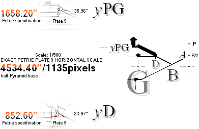
852.60’’ ±
0.30’’ ¦ PETRIE — PetrieCH7.39
The ill Petrie synchronized vertical scale has
significant overshooting with growing height — with a perfect horizontal Petrie
measure representation. The verticality issue might be the result of an (after 1883,
less precise) electronic copy. We do not know that, however.
The point:
• Using
the present Internet Petrie Plate9 (”Plate.ix”) drawing for comparing or
analyzing measures will generate direct errors.
• We can
use it for (narrow vertical) illustrations to Petrie’s reasoning or
orientation:
• But the
vertical metric scale is corrupted :
• Consult
only the Petrie specified values.
• We have
no other reference.
We try to stick consequently to Petrie’s specified
values and their tolerances (two decimal rounded inch values — at least six
decimal rounded meter values: type 25.12’’ = 0.6380480000 M).
Several (many) Cheops Pyramid
sources @Internet uses a diversity of (modern academic invented, what we know)
so called units (type CUBIT [also sparsely mentioned by Petrie (some 100R/3 = 20.6’’)]) — at worst
specified in centiMeter cM units type ”51.2 cm” — a quite useless information
and specification in this presentation (0.512xxx at least to find a fair Petri
2 decimal inch correspondence).
(It seems strange why persons
after the thorough Petri measurements do not adopt Petrie’s measuring standard:
1’’ = 0.025400
M).
(Maybe it is more convenient to
use the unit OneARM, considering the age of the place, and its level of
intelligence).
We are 100% dependent on that precision standard in this comparing Petrie presentation.
R = (–1 + √5)/2 = 2/(1 + √5) ¦ 1/R = 1 + R ¦ R
= 0.618033989.. GOLDEN SECTION CONSTANT
AS in the 2017 original DEDUCED
THE bd=h² GOLDEN SECTION MATRIX SYSTEM
THE PYRAMID/triangle/GoldenSectionSolutions ANGLE ARCtan 1/√R is the one where the PyramidMatrix relation bd=h2 counts.: C° = 51.8272923730° = 51° 49’ 38.252543’’.
Geometry ¦ Algebra ¦ Circle-square
matrix algebra ¦ b¦Pn Chart matrix algebra ¦ b¦Pn matrix algebra ¦ Geometric matrix series ¦ Pyramid matrix ¦ METHOD
SEE ALSO LIGHT’S GRAVITATIONAL DEPENDENCY FROM CHEOPS
RECTANGLE bd=h² MATHEMATICS — really: basic physics force
math — never mentioned in modern teaching system.
IT UNVEILED THE DEDUCTION OF THE ATOMIC NUCLEUS — Planck constant h = mcr = THE NEUTRON (TheNeutronSquare):
IT UNVEILED THE APPEARANCE OF THIS PRODUCTION’S TESTING rJCIRCL CheopsPyramid E GOLDEN SECTION PYRAMID MATRIX COMPLEX.
A special article explains the
deduction of the Golden Section’s central line:
ArcTan½ line angle 26° 33’ 54.18424’’ = 26.565051177°.
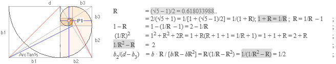
![]()
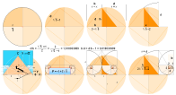
![]()
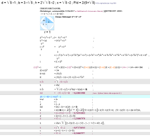
GScSMal: GS
circle-square
matrix algebra
![]()
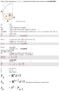
GSbPnCHmal: GS
b¦PnCHART matrix algebra
![]()
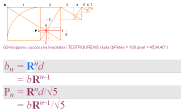
GSbPnMaSER: GS
b¦Pn matrix series
![]()
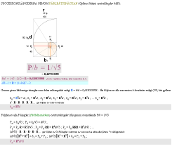
GSmaSeries: GS
geometric matrix series
![]()
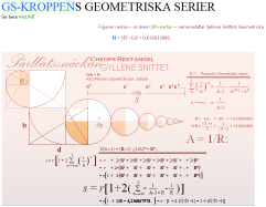
PyramidMatrix: GS
Pyramid matrix
![]()
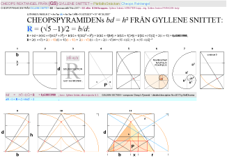
GoldenSectionMatrixSYSTEM ¦ GSgeometry
¦ GSalgebra ¦ GScSMal ¦ GSbPnCHmal ¦ GSmaSeries ¦ GSPyramidMatrix
¦ GSgeometry
VOOD: GoildenSectionMatrixSYSTEM ¦ RITa ¦ EARTHrJCIRCLE
Petrie-EARTHrJCIRCLE-CHEOPSRECTANGLE-CheopsPyramid verifications
ANY METRIC DEVIATION BETWEEN PETRIE’S MEASURED AND PRESENTED VALUES, AND THE IDEAL GOLDEN SECTION CHEOPS RECTANGLE PYRAMID (GoldenSectionMatrixSYSTEM) IS IN THIS SCALING METHOD VIEW AS BELOW: NOT VISIBLE AT ALL. No provable difference. Not by angles, not by metrics.
THE TEN FIRST
PrJC-ver1 ¦ PrJC-ver1 ¦ PrJC-ver1 ¦ PrJC-ver1 ¦ PrJC-ver1 ¦ PrJC-ver1 ¦ PrJC-ver1 ¦ PrJC-ver1 ¦ PrJC-ver1 ¦ PrJC-ver1 ¦
The end result, always, no exceptions:
END RESULT STRUCTURE
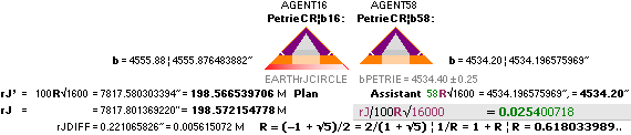
————————————————————————————————————————————————
Explain:
The EARTHrJCIRCLE
Pyramid Agent16
has the PLAN construct in the GOLDEN SECTION
MATRIX CHEOPS RECTANGLE bd=h² SYSTEM. Agent16 is
supported and assisted by Agent58 — A Petrie tolerated
spouse. Calculated values always, no exceptions, should always end up INSIDE
the Petrie measured values — with Petrie’s specified tolerances.
— So: The PLAN defines the Petrie measured
Construct — or not at all.
The reader/author has only to find one single exception from this named order, and this presentation has no longer a meaning.
METHOD: Structure
SO WE ONLY HAVE TO PINPOINT STRICTLY VISUAL CONGRUITIES USING THE BELOW DEPICTED ab MATRIX SYSTEM. AND IF, AND WHERE, WE CAN FIND SUCH CONGRUITIES, ANALYZE THEM MATHEMATICALLY THROUGH THE GOLDEN SECTION DEFINED MATRIX SYSTEM MATHEMATICS.
— SEE A FIRST (CLEAR) EXAMPLE OF HOW IT WORKS IN FirstEX and The7BEGIN.
d Scaled version of Flinders
Petrie’s measured Cheops Pyramid EastWest — half
Pyramid base (b) from Petrie’s 4534.40’’ ± 0.25’’ :
SCALING: (b=4534.40’’)/100pixels.
c extracted inner structure (the cropped connection over x has been omitted here due to Petrie’s own description of its partly unavailable, and partly adventurous, measuring environment: several different @Internet sources have different solutions to this so called Grotto passage, and no related precise scaled version is known here).
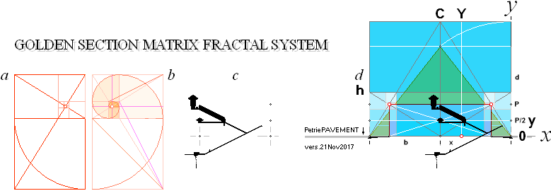
b The complex Circle-Square Golden Section Matrix System, here detailed in
CircleSquare Matrix Algebra ¦ b¦PnCHART matrix algebra
¦ b¦Pn matrix series
¦
Geometric
matrix series ¦ Pyramid matrix
a As in b but only the pure fractal linear-square matrix
— If the Golden Section Matrix calculated values
lie inside Petrie’s specified tolerances, the calculated and the measured
renders same status. And we (here) state that a
Petrie-rJCIRCLE-CheopsRectangle-CHEOPS-PYRAMID
verification has been solidified.
— ONLY — and nothing else but only — if all (the general shape and content) Petrie presented measures win such a status, we can state that the calculated values from the Golden Section complex defines the Petrie stated quantities. That holds of course only as far as an actual measure is available — and related reliable:
— The partially generally bad shape of the remnants of the building includes the long gone outer casing. Except related to a few stones at the base (Illustrated) from where Petrie got the Pyramid North reference to the measures, there are no other left ideal reference points (bPETRIE=4534.40’’) relating the Pyramid’s outer shape.
— If we find even one single Petrie measure value that cannot be explained by the Golden Section complex, we must surrender and admit that there is no overall accord.
As yet (Jan2024) no such disclaiming argument has shown up. Still searching, testing, recalculating, reanalyzing, checking, rechecking .. Again. Please.
THE METOD EXEMPLIFIED:
Method exemplified in determining the suggested GS plan’s exact corridor height —
calculating the difference between two (GS) Golden Section Matrix System
alignments, using line intersection mathematics (DeLIC) from the
suggested (The7) basic points on the ARCtan½ line. See detailed description
in
DETERMINING THE B-POINT — TheTunnelCross (BpointDetermination).
VOOD —VERIFICATION METHOD¦ MethodSTRUCTURE
¦ METHOD ¦ NotesOriginal2017
¦ CalCards ¦ Kalkylkort ¦ CONTENT
Notes to the original presentation 2017
— The 2017 version uses the GS (GoldenSection, Swedish GYLLENE SNITTET) matrix b-square prefix
(bR^n)
as the Petrie CR agent’s 4534.32’’ — on the actual Pyramid base
b = 4556.01’’ rJCR agent.
— These later versions (2020+)
have only one and the same (GpointParams) GS matrix base prefix:
• we do NOT mix different
Pyramid Agents with each others GS matrices: GSmatrixAgentA for AgentA,
GSmatrixAgentB for AgentB only.
— Agent16’s
b[rJCR¦b16] = 4555.88’’ (4555.876483882) connects the slightly larger Pyramid agent
(Agent 16: the actual original Plan body as GS-related).
— Its half Pyramid base b =
4555.88 belongs to the (for Petrie’s Cheops Pyramid) hidden construction plan.
And as such orderly as seen DEFINITELY NOT within the slightly smaller PetrieCP
4534.40’’ Pyramid half base tolerance (±0.25’’).
— The larger Agent16 (the
Construction Plan) gives preferences to the final construct ALONG WITH
calculated data from Agent58 —
exposing the edifice which Petrie did measure on.
How it works on the end picture is exemplified and
illustrated/proven in The Seventh Result: the different
Pyramid Agent calculated parameters in the corridor crossing points define the
Petrie measured B-point, and the corridor height, and the thickness of Petrie’s
measured 19th stone masonry course — only using the offset distance (21.68’’)
as »a final concealment» between the two agents 16¦58. Very sophisticated
stuff. No doubt. No way a student can reveal that hidden plan, unless familiar
with our deduced — and unveiling EARTHrJCIRCLE
and its related Resolution217: Petrie’s 4534.40’’ value
— with 99.9999832% certainty.
However: If the reader finds other ways, don’t forget to update.
Also the connection between that crossing point parameters and
the end part of the Great Gallery (TCC) exposes how the Petrie measured
data becomes fully explained through the rJCIRCLE calculations with its
associated Agents 16¦58.
— We would state, that the
earlier 2017 version did not have the later (2020+) ambition in calculating all
the different details, only the (at that time the) most prominent, proving a
general match.
— So comparing with the 2017
version will not do here, »except for the most basic».
This presentation (Jan2024) is more or less a compressed — more
dense — description of the whole complex in the 2020 version (CheopsATLAS). We frequently refer links
from there (and the Golden Section Cheops Rectangle basic mathematics in the
Swedish 2017 original CheopsRektangel).
CalCards: Kalkylkort: NOTE. OpenOffice SpreadSheet. Swedish
EditionOnly
CalCards
Accounted mathematics result in the
open and free OpenOfficeCalc Spread Sheet program — in the Swedish cell code
version
PART OF THE AIM behind these open (author’s working original) available CalCards is
of course
• first
the availability of the proving mathematics on exact basics
• with
the possibility for any interested reader to make own tests, or further,
whatever
•
offering a complete open access index to the complete work behind the main text :
• we
leave no one behind in related physics and mathematics, as far as we can.
——————————————————————————————————————
THE SWEDISH OPEN OFFICE CELL CODED VERSION —
we do not
know how the cell code looks if opened in an English version — if at all ;
— We should have thought about that from the start [ 2008 ] — which we
didn’t.
kalkylkorten nedan DIREKT
FRÅN DEN HÄR WEBBLÄSAREN CheopsATLAS2024.ods — se öppningsmanual om ej
redan bekant — eller kopiera URL:en
nedan till valfri webbläsare (vilket som fungerar — förutsatt att SVENSKA
VERSIONEN av gratisprogramvaran OPEN OFFICE finns installerad på datorn)
http://www.universumshistoria.se/AaKort/CheopsATLAS2024.ods
TABS named (Swedish) Tabell 1 2 3 ..,
T1 2 3 (Engl. Table)
——————————————————————————————————————————————
T1 A1+
General light speed gravitational dependency evaluations;
A24+ Initiating WorkingDraft compilations, the different Pyramid Agents,
preparing ..
G48+ Strange OpenOffice mathematics behavior: ” INTEGER(29) = 28” — transfering
angle DMS format to degrees
A54+ Height of Cheops
Pyramid 19th Course,
comparing Petrie data with Agent16 calculated results
A65+ as above — multiple testing inputs
T2 A1+ Agent 16¦58 — the
entire calculations compressed in successive order with the npin factor
selection;
Additional evaluations blocks, where cell space allows (specified in the main
text, if used)
T3 Empty,
for use
T4 RESTS
FROM FIRST DRAFT (can be overwritten)
T5 A1+ First
compiled results preceding T2 — with additional drafting evaluation blocks
(incorporated in T2)
T6 Like
T4 — initiating preparations ..
Cheops ATLAS
Glaciation — Jan2020 ¦ Appended Jan2024 on Resolution 217.
innehåll: content SÖK på denna sida Ctrl+F · sök alla ämnesord överallt i SAKREGISTER · förteckning över alla
webbsidor
Universums Historia —
Cheops ATLAS Glaciation
innehåll
CONTENT
CallingAtlantis — Roger .. Roger ..
Mayday .. Mayday .. ATLANTIS NEVER EXISTED. So you keep saying
..
BaG —
Bakckground
AtlantisCHEOPS — GEOLOGICAL
GLACIATION DATA PROMOTE AND SUPPORT THE GEO ATLANTIS ALTERNATIVE
AgifRef — America Africa-Europe
continental drift map 400Mya till now (ya, years ago)
MaKartan — The situation
some 3Mya
IcyNorth —
evolving scenery
WikiQuater —
glaciation and continental drift
InterGlac100 — fast
100y glaciation variations
WikiHolo —
Wikipedia (15 000 - 10 000 ya) Holocene quote
WikiSahara — The
African humid period during holocene
NOTE24Feb2024 — Connecting to Appendix:
Resolution 217
FAN — INTENSIFIED EXPLANATION
DeTiLi —
DEVELOPING TIME LINE
GGVD — GEOLOGICAL GLACIATION VARIATION DATA
WikiTimeGlac — WIKIPEDIA, TIMELINE
OF GLACIATION
Seager2007 — ”simply
astounding”
Function — THE
UNPROVEN FRAGMENTING AMERICA-AfricaEUROPE BARRIER
NorthOnly — the reported
abrupt climate changes pertain to the Northern hemisphere only
NotedFacts — short
illustrated summary
AppendixRESOLUTION
217 — ADDITION 10Jan2024
-------------------------------------------
RITa — READ IT AN WEEP — Explained in Resolution 217
EARTHrJCIRCLE —
the neutron Dmax and Planck constant defined Earth mass neutron max density
spherical radius
EARTHrJCIRCLEequation — Resolution 217,
explaining the idea: bPETRIE’S 4534.40 as 4534.399236463: A 99.9999832% MATCH
bPetrieDetermination —
Resolution 217, explaining the idea: bPETRIE’S 4534.40 as 4534.399236463: A 99.9999832% MATCH
Resolution217 — INTRODUCTION
First result ChEX — EXAMPLE:
DETERMINING/testing THE CORRIDOR HEIGHT — the scaling precision
FirstEX —
Ch = 47.3055758’’ ¦ Petrie measure: 47.26’’ (± 0.17’’) — approved
Res1 —
RESULT 1
EXPLAINResolution217 —
identifying the numerical value of 4534.40 from the rJCIRCLE
GoldenSection Pyramid complex
PyramidData — THE 4
PYRAMID AGENT’S BASIC DATA
PetrieCP — Petrie’s measured Cheops
Pyramid
bPetrieTol —
Petrie’s half Pyramid base tolerance ± 0.25’’ — sets a measure by length
reference standard to all the distances in this presentation, unless otherwise
stated
PetrieCR — Petrie’s Pyramid base
determined [ 4534.40’’ ± 0.25’’ ] corresponding Golden Section Cheops Rectangle
TolASP —
Petrie related general tolerance aspect
rJCR — EARTH rJCIRCLE defined Cheops Rectangle
rJCRtab ....................... — rJCR Golden Section related tabled values
rJCRb —
rJCR half Pyramid base
hrJ —
rJCR Pyramid height
rrJ — rJCR
Cheops Rectangle construct circle
hDIFFmain ................... — rJCR – PetrieCR = 27.482385374’’ ; 27.48’’
= 0.698052589 M
Agent58 — PetrieCR¦b58 — bPetrie =
4534.20’’ — Petrie’s 4534.40’’
± 0.25’’ associated
Agent16 — PetrieCR¦b15 — bPetrie =
4555.88’’ — rJ associated Petrie Golden Section Agent Pyramid, same as Agent 58
but with its Pyramid base rJ associated
Pref —
Golden Section P
CalTePEM —
calculating the Petrie measures — MiUNIT details defining a close relation to
Meter and INCH
ExplainingGSPA —
EXPLAINING THE DIFFERENT GOLDEN SECTION CHEOPS RECTANGLE MATHEMATICS bd=h² PYRAMID AGENTS
Content217 [
bd=h² Cheops Rectangle basic math second degree equation illustrated below]
CaseHistory — 2017+
TST —
THE SIMPLE TEST
Rref —
the Golden Section Constant
rJref — EXACT CALCULATION IN OPEN OFFICE OF THE
EARTHrJCIRCLE neutron Dmax Planck constant related value
k0ref — the
rJ Golden Section Pyramid transfer factor
TheUNITS — The regular Resolution217 article
FullyRelated THE
GOLDEN SECTION EARTHrJCIRCLE DEFINITION OF PETRIE’S 4534.40’’ HALF BASE CHEOPS
PYRAMID
Explain217 THE
GOLDEN SECTION EARTHrJCIRCLE DEFINITION OF PETRIE’S 4534.40’’ HALF BASE CHEOPS
PYRAMID
FirstPROOF —
The rJCheopsRectangle contains a numerical »automatic meter(1)-inch(0.0254)»
unit
MiU — Meter
Inch UNIT
Special —
xBhigh has a simple numerical y-equivalent
INCHref —
the INCH unit in the rJCIRCLE complex
rJprim — the rJCIRCLE Cheops
Rectangle associated — k = rJ = 198.566539706 M
The58 The
58 factor
bPETRIE 4534.40’’
± 0.25
The18 The
18 factor
The16 The
16 factor
-------------------------------------------
CALTEP —
CALCULATING THE PETRIE VALUES
Num217REF —
2 • 3 • 18 = 108 = 2 • 2 • 3 • 3 • 3; 108 + 109 [PRIME] = 217. RESOLUTION 217:
(b¦2b¦h¦d¦x¦r¦P¦P/2¦P/r¦k¦R¦k0)/(h¦rJR –
h¦PetrieCR = 27.482385374’’ ¦ 27.48), CheopsATLAS2024.ods Tabell5 A7+:
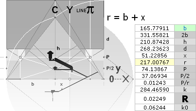
CheopsATLAS2024.ods Tabell5 A7+ — how it was found: the
contracted constructF: Cheops
Rectangle bd=h²:
— IN THIS
Pyramid/TriangleFORM bd = h²
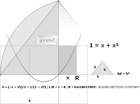
A SECOND DEGREE EQUATION
shows up as 1 = x + x² — with the solution: x = R = 0.618033989: the Golden section constant.
The equative form is: There is only one unique Pyramid¦triangle body where the product of
its base b and its sloping side d
equals the
height h:s square. That is: R, the Golden section
matrix system solutions. Basic math. See further: C19thITERATED.
PetriePyramidAngle — quoting Petrie on specified Cheops Pyramid data
RadioCarbonDating — new perspective on The Cheops
Pyramid Origin — and the Atantis aspects: safe mortar datings — the
mortar contains organic ashes
EntrancePETRIE THE MATHEMATICS PROVING THE
GOLDEN SECTION CONNECTION
Second result THICK19th — The Triangle Equation — how Petrie
reckoned the 19th course’s stone layer’s THICKNESS — builds on FirstResult
EquationSecond — the AB Equation
CONSOLIDATION PROOF PETRIE.GOLDEN
SECTION SOLUTIONS
-------------------------------------------
MENU the following sections in order by their link names — proving
the Petrie coherences
-------------------------------------------
The7BEGIN THE MAIN CONSTRUCTION LINE. the seven points
K L M G H B A
GpointParams —
determining K [F] G H A
FIRSTyxA —
the Enter North Pyramid side [ A ] xy coordinates — featuring the PLAN DRAFT
construct
BpointDetermination — DETERMINING THE B-POINT — TheTunnelCross
DeLIC —
Deducing the LINEintersectingCONNECTION
BupLowOrg —
how it is organized
BPco —
HIGH POINT B-point coordinates — Agent16¦58 PLAN COORDINATES SOLVED
BPAL —
THE THREE POINT DETERMINATION TRIANGLE EQUATION — solving for a dual line cross
CORIH —
LOW POINT corridor height coordinates —
Agent 16¦58
LineCROSSxy —
B POINT DETERMINATION
xBhigh B
POINT DETERMINATION
yBhigh B
POINT DETERMINATION
ResultBpoint — table presenting resulting values — Bpoint
HIGH and LOW
-------------------------------------------
SolutionA — INTRODUCTION
TO SOLVING THE HEIGHT OF THE 18th ROOF — Petrie’s 19th FLOOR
THEnFACTOR —
diving into the inner of Cheops Pyramid
IdealAndConstructAngle — THE REASON WHY THE
PYRAMID’S ~100 M LONG DESCENDING NARROW TUNNEL HAS NOT THE GS PYRAMID CONSTRUCT
EXACT ArcTan½ ANGLE
nSymmetry — Petrie’s subterranean
details — the two Pyramid Agents 16¦58 Solve the Problem
PetrieROOF18 —
quote
THEn — Petrie’s
subterranean details — the two Pyramid Agents 16¦58 Solve the Problem
Third result rJCIRCLEverified
— rJCIRCLE COMPLEX VERIFIED —
y18thRoof = 668.20’’
y18ROOFcon —
RESULT HAS CONSEQUENCES LEADING TO FURTHER RESULTS — introducing [ » Petrie’s »
] HANGLE and PANGLE
HanglePangle — the decisive angles leading to the solutions — The
Eighth and Ninth result — but Petrie has added
a Question Mark on our Pangle tolerance ” ± 5 ’’ ? ” :
IF we are allowed to round 17.486
arc seconds to 18 — Petrie’s .. 23’’ ±
5 ’’ — we are precisely on the edge of approved — if skipping Petrie’s question mark:
Rounding 17.48 arc seconds becomes
17.5 — »which becomes 18» — if arc second rounded on a questionable edge.
CDetailsH18 CALCULABLE
GOLDEN SECTION MATRIX DETAILS
ExtraCON —
EXTRACTING THE RECURRING CONSTANTS
nHYPO detail
Rot125 method
om ARCtan½: dHYPO = √ d² + [d/2]² = d √ 1 + 1/4 = d √1.25
8th PANGLE — PANGLE — 26° 31’ 17.486’’ ¦ Petrie: 26° 31’ 23’’ ±
5’’ ? — See note below on HangPang.
PetriePangle —
Petrie as quoted
8th EighthResult
dREF detail
9th HANGLE — HANGLE —
26° 28’ 58.774’’ ¦ Petrie: 26° 29’ ± 1’
PetrieHangle —
Petrie as quoted
9th NinthResult
ConPlanG —
construction plan G
Results123 —
summing the first three results
ExplainA —
relating the Second Result
yATHcalc —
ascending tunnel height calculations from previous results
BUARM detail,
B-point Upper Ascending ROOF Mean average
yATH detail,
Ascending Tunnel Height, base value
yBarm detail,
BUARM + yATH
TUNNELcross plan
in view
EPA EntrancePassageAngle
— DETERMINING/testing THE »exact» CORRIDOR HEIGHT
PetrieTol017 —
relating Petrie on a specific tolerance specification — referring a collected
table with Petrie’s specified angles
yBlimit detail
— absolute Construct Limit HBA floor
yHaBe yHangleBend
yPaHe yPangle
Hend
yConB —
absolute HBA construct limit floor base
Fourth result PetrieBpointCalculated
Tenth result TCC THE
CONTRACTED CONSTRUCT — from tunnel cross to Gallery top — The Great Step
Seventh result EXcontractedConstruct — proving the Pyramid Agents 16¦58
horizontal offset to merge with the Petrie B-point measured descending passage
roof — proving a Contracted Construct
Sixth result Course19thHeight hPetrie EXACT 19th Course
HEIGHT
SIOillustrated detail
to the Pyramid casing Petrie spotting details .. Secure Inspection Offset
TheDpoint xGalleryNORTH-yQueenFLOORin
EGSf —
Explaining Golden Section fits
M74GS Golden Section Matrix System example
-------------------------------------------
PCS PYRAMID
COORDINATE SYSTEM — The Petrie x-coordinate preferred preference: from North
Pyramid base tip, to South
PetriePlate9Issues Corrupted vertical scale, illustrated
and exemplified
-------------------------------------------
Geometry ¦ Algebra ¦ Circle-square
matrix algebra ¦ b¦Pn Chart matrix algebra ¦ b¦Pn matrix algebra ¦ Geometric matrix series ¦ Pyramid matrix
-------------------------------------------
VOOD VERIFICATION
METHOD — Petrie-rJCIRCLE-CheopsRectangle-CheopsPyramid verifications
MethodSTRUCTURE — The Pyramid Agents
METHOD —
how it is done
NotesOriginal2017 Some 2017 redundant details for
clarification in this presentation Jan2024
CalCards —
the free [Swedish edition] OpenOffice spread sheet collected calculated
accounted results
-------------------------------------------
referenser
[HOP]. HANDBOOK OF PHYSICS, E. U. Condon, McGraw-Hill 1967
Atomviktstabellen
i HOP allmän referens i denna presentation, Table 2.1 s9–65—9–86.
mn =
1,0086652u ...................... neutronmassan
i atomära massenheter (u) [HOP Table 2.1 s9–65]
me =
0,000548598u .................. elektronmassan
i atomära massenheter (u) [HOP Table 10.3
s7–155 för me , Table 1.4 s7–27 för u]
u = 1,66043 t27 KG .............. atomära massenheten [HOP Table 1.4 s7–27,
1967]
u = 1,66033
t27 KG .............. atomära massenheten [ENCARTA 99 Molecular
Weight]
u = 1,66041 t27 KG
............... atomära massenheten
[FOCUS MATERIEN 1975 s124sp1mn]
u = 1,66053886 t27 KG ........ atomära
massenheten [teknisk kalkylator, lista med konstanter SHARP EL-506W
(2005)]
u = 1,6605402 t27 KG .......... atomära
massenheten [@INTERNET (2007) sv. Wikipedia]
u = 1,660538782 t27
KG ...... atomära massenheten [från www.sizes.com],
CODATA
rekommendation från 2006 med toleransen ±0,000 000 083 t27 KG (Committe
on Data for Science and Technology)]
c0 = 2,99792458 T8 M/S ........ ljushastigheten
i vakuum [ENCARTA 99 Light, Velocity, (uppmättes i början på
1970-talet)]
h = 6,62559 t34 JS ................. Plancks konstant [HOP s7–155]
— Det internationella standardverket om universum sammanställt vid universitetet i Cambridge, The Cambridge Encyclopaedia of Astronomy, London 1977.
[BKL]. BONNIERS KONVERSATIONS LEXIKON, 12 band A(1922)-Ö(1928) med SUPPLEMENT A-Ö(1929)
t för 10–, T för 10+,
förenklade exponentbeteckningar — simplified notations: t for TEN
RAISED TO minus and T for TEN RAISED TO plus.
MAC, här ofta använd
förkortning för Modern ACademy — etablerad
vetenskap sedan början av 1800-talet
TNED — Related PHYSICS And MATHEMATICS —
Se särskild djupbeskrivning av innebörden i begreppet relaterad framställning.
![]()


(Toroid Nuclear Electromechanical Dynamics), eller Toroidnukleära Elektromekaniska
Dynamiken är den dynamiskt ekvivalenta resultatbeskrivning som
följer av härledningarna i Planckringen
h=mnc0rn, analogt Atomkärnans
Härledning. Beskrivningen enligt TNED är relaterad,
vilket innebär: alla, samtliga, detaljer gör anspråk på att vara fullständigt
logiskt förklarbara och begripliga, eller så inte alls. Med TNED förstås
(således) också
RELATERAD FYSIK OCH
MATEMATIK. Se även uppkomsten av termen TNED i Atomkärnans Härledning.
See
also TNED FROM THE BEGINNING (Swedish
edition only Aug2019).
SHORT ENGLISH — TNED in general is not found @INTERNET except under
this domain
(Universe[s]History, introduced @INTERNET 2008VII3).
TNED or Toroid Nuclear Electromechanical Dynamics is
the dynamically equivalent resulting description following the deductions in THE PLANCK
RING, analogous AtomNucleus’ Deduction. The
description according to TNED is related, meaning: all, each, details
claim to be fully logically explainable and understandable, or not at all. With
TNED is (hence) also understood RELATED PHYSICS AND MATHEMATICS. See also the
emergence of the term TNED
in AtomNucleus’ Deduction.
Senast uppdaterade version: 2025-01-13
*END.
Stavningskontrollerat 2020-03-26¦26Mar2020—23¦25Jan2024.
rester
*
åter till portalsidan · portalsidan är www.UniversumsHistoria.se
≈
Δ Ĵ ∫ α √ π → ∞ τ π ħ
ε UNICODE — often used charcters in mathematical-technical-scientifical
descriptions
σ
ρ ν ν π τ γ λ η ≠ √ ħ
ω → ∞ ≡ ↔↕ ħ ℓ
Ω
Φ ϕ ϕ
Ψ Σ Π Ξ Λ Θ Δ ~
α
β γ δ ε λ θ κ π ρ τ φ
σ ω ∏ √ ∑ ∂ ∆ ∫ ≤ ≈
≥ ← ↑ → ∞ ↓
ζ
ξ
Arrow symbols, direct via
Alt+NumPadKeyboard: Alt+24 ↑; 25
↓; 26 →; 27 ←; 22 ▬
23
↨ — also 18 ↕; 29 ↔
åter till portalsidan · portalsidan är www.UniversumsHistoria.se